第10章地球に似た惑星――金星と火星Earthlike Planets: Venus and Mars
Ancient Lakes and Glaciers古い湖と氷河
The rovers (Spirit, Opportunity, Curiosity, and Perseverance) that have operated on the surface of Mars have been used to hunt for additional evidence of water. They could not reach the most interesting sites, such as the gullies, which are located on steep slopes. Instead, they explored sites that might be dried-out lake beds, dating back to a time when the climate on Mars was warmer and the atmosphere thicker—allowing water to be liquid on the surface.
Spirit was specifically targeted to explore what looked like an ancient lake-bed in Gusev crater, with an outflow channel emptying into it. However, when the spacecraft landed, it found that the former lakebed had been covered by thin lava flows, blocking the rover from access to the sedimentary rocks it had hoped to find. However, Opportunity had better luck. Peering at the walls of a small crater, it detected layered sedimentary rock. These rocks contained chemical evidence of evaporation, suggesting there had been a shallow salty lake in that location. In these sedimentary rocks were also small spheres that were rich in the mineral hematite, which forms only in watery environments. Apparently this very large basin had once been underwater.
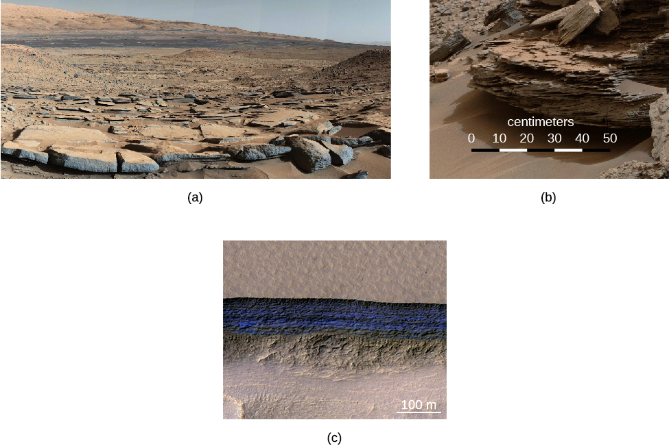
The Curiosity rover landed inside Gale crater, where photos taken from orbit also suggested past water erosion. It discovered numerous sedimentary rocks, some in the form of mudstones from an ancient lakebed; it also found indications of rocks formed by the action of shallow water at the time the sediment formed (Figure 10.30).
Even today there is evidence of large quantities of ice just below the surface of Mars. In the mid-latitudes, high-resolution photos from orbit have revealed glaciers covered with dirt and dust. In some cliffs, the ice is observed directly (see Figure 10.30). Perseverance is exploring the 45-km-wide crater Jezero, which is a dusty former lakebed and river delta with evidence of large rocks deposited by ancient floods. These glaciers are thought to have formed during warm periods, when the atmospheric pressure was greater and snow and ice could precipitate. They also suggest readily available frozen water that could support future human exploration of the planet.
Gale Crater and Underground Ice Deposits.ゲール・クレーターと地下の氷の堆積層
credit a: modification of work by NASA/JPL-Caltech/MSSS; credit b: modification of work by NASA/JPL-Caltech/MSSS; credit c: modification of work by NASA/JPL-Caltech/UA/USGS · JPL image use policy
Figure 10.30 (a) This scene, photographed by the Curiosity rover, shows an ancient lakebed of cracked mudstones. (b) Geologists working with the Curiosity rover interpret this image of cross-bedded sandstone in Gale crater as evidence of liquid water passing over a loose bed of sediment at the time this rock formed. (c) Ice bands a hundred meters tall are visible in blue in a cliff-face on Mars, suggesting large deposits of frozen water buried just a few meters below the surface. Note that the blue color has been exaggerated in this photo, taken by the Mars Reconnaissance Orbiter spacecraft. (credit a: modification of work by NASA/JPL-Caltech/MSSS; credit b: modification of work by NASA/JPL-Caltech/MSSS; credit c: modification of work by NASA/JPL-Caltech/UA/USGS)