第10章地球に似た惑星――金星と火星Earthlike Planets: Venus and Mars
Martian Cracks and Canyons火星の割れ目と峡谷
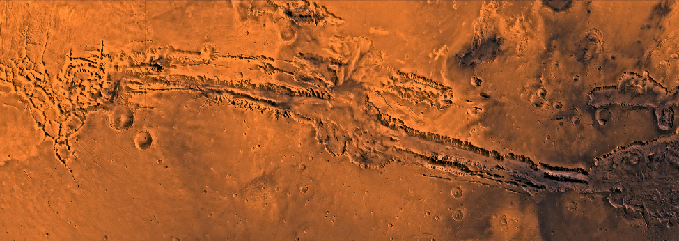
The Tharsis bulge has many interesting geological features in addition to its huge volcanoes. In this part of the planet, the surface itself has bulged upward, forced by great pressures from below, resulting in extensive tectonic cracking of the crust. Among the most spectacular tectonic features on Mars are the canyons called the Valles Marineris (or Mariner Valleys, named after Mariner 9, which first revealed them to us), which are shown in Figure 10.19. They extend for about 4000 kilometers (nearly a fifth of the way around Mars) along the slopes of the Tharsis bulge. If it were on Earth, this canyon system would stretch all the way from Los Angeles to Washington, DC. The main canyon is about 7 kilometers deep and up to 100 kilometers wide, large enough for the Grand Canyon of the Colorado River to fit comfortably into one of its side canyons. Viewers of the movie “The Martian” can see a recreation of these canyonlands, as the film’s hero takes a long trip through a spectacular (and somewhat exaggerated) presentation of this part of Mars.
英語のヒント
タルシス隆起には、巨大な火山に加えて、興味深い地形が多くある。この領域では、下からの大きな圧力によって表面自体が上へ膨らみ、その結果、地殻に広範な構造的な割れ目ができた。火星で最も壮観な構造地形の一つは、図10.19に示すマリネリス峡谷である。この名は「マリナーの谷々」を意味し、初めてその姿を見せたマリナー9号にちなんでいる。峡谷はタルシス隆起の斜面に沿って約4000 km、火星の全周のほぼ5分の1にわたって延びる。地球にあれば、ロサンゼルスからワシントンD.C.まで、ずっと続く峡谷群となるだろう。主要な峡谷は、深さ約7 km、幅は最大100 kmで、コロラド川のグランドキャニオンが、脇の峡谷の一つへ余裕を持って収まるほど大きい。映画『オデッセイ』(The Martian)の観客は、この峡谷地帯を再現した映像を見ることができる。主人公が、壮観でいくらか誇張された、この火星の領域の眺めの中を、長い旅に出るからである。
Heavily Eroded Canyonlands on Mars.激しく侵食された火星の峡谷地帯。
credit: NASA/JPL/USGS · JPL image use policy
Figure 10.19 This image shows the Valles Marineris canyon complex, which is about 4000 kilometers long and 8 kilometers deep. (credit: NASA/JPL/USGS)
図10.19 この画像は、長さ約4000 km、深さ8 kmのマリネリス峡谷群を示す。(提供:NASA/JPL/USGS)
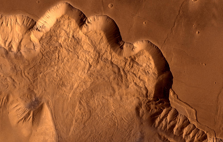
The term “canyon” is somewhat misleading here because the Valles Marineris canyons have no outlets and were not cut by running water. They are basically tectonic cracks, produced by the same crustal tensions that caused the Tharsis uplift. However, water has played a later role in shaping the canyons, primarily by seeping from deep springs and undercutting the cliffs. This undercutting led to landslides that gradually widened the original cracks into the great valleys we see today (Figure 10.20). Today, the primary form of erosion in the canyons is probably wind.
英語のヒント
ここで「峡谷」という語は、少し誤解を招く。マリネリス峡谷には出口がなく、流れる水によって削られたものではないからだ。基本的には、タルシスの隆起を生んだのと同じ地殻の張力が作った、構造的な割れ目である。しかし、その後、地下の深い湧き水がしみ出し、崖の下部を削ることを主として、水も峡谷の形を変える役割を果たした。この下部の侵食は地滑りを起こし、もとの割れ目を徐々に広げて、現在見られる大きな谷にした(図10.20)。現在、峡谷で働く主な侵食作用は、おそらく風である。
Martian Landslides.火星の地滑り。
credit: modification of work by NASA/JPL/USGS · JPL image use policy
Figure 10.20 This Viking orbiter image shows Ophir Chasma, one of the connected valleys of the Valles Marineris canyon system. Look carefully and you can see enormous landslides whose debris is piled up underneath the cliff wall, which tower up to 10 kilometers above the canyon floor. (credit: modification of work by NASA/JPL/USGS)
図10.20 このバイキング周回機の画像は、マリネリス峡谷群をつなぐ谷の一つ、オフィル峡谷を示す。よく見ると、巨大な地滑りによる破片が、谷底から最大10 kmそびえる崖の下に積み重なっているのがわかる。(提供:NASA/JPL/USGSの作品を改変)
While the Tharsis bulge and Valles Marineris are impressive, in general, we see fewer tectonic structures on Mars than on Venus. In part, this may reflect a lower general level of geological activity, as would be expected for a smaller planet. But it is also possible that evidence of widespread faulting has been buried by wind-deposited sediment over much of Mars. Like Earth, Mars may have hidden part of its geological history under a cloak of soil.
英語のヒント
タルシス隆起やマリネリス峡谷は壮観だが、全般に、火星で見られる構造地形は金星より少ない。これは一部には、より小さい惑星で予想されるように、全体的な地質活動の程度が低いことを反映しているのかもしれない。しかし、火星の広い範囲で、広範な断層運動の証拠が、風で堆積した物質に埋もれている可能性もある。地球と同じく、火星も地質学的歴史の一部を、土壌の覆いの下へ隠しているのかもしれない。
The View on the Martian Surface火星の表面の眺め
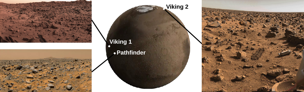
The first spacecraft to land successfully on Mars were Vikings 1 and 2 and Mars Pathfinder. All sent back photos that showed a desolate but strangely beautiful landscape, including numerous angular rocks interspersed with dune like deposits of fine-grained, reddish soil (Figure 10.21).
英語のヒント
火星への着陸に最初に成功した宇宙機は、バイキング1号・2号と、マーズ・パスファインダーだった。すべてが、荒涼としていながら、不思議に美しい風景の写真を送り返した。そこには多数の角ばった岩石があり、粒子の細かい赤みを帯びた土壌が、砂丘のように堆積して、岩々の間を埋めていた(図10.21)。
Three Martian Landing Sites.三つの火星着陸地点。
credit “Viking 1”: modification of work by Van der Hoorn/NASA; credit “Pathfinder”: modification of work by NASA; credit “Viking 2”: modification of work by NASA; credit Mars: modification of work by NASA/Goddard Space Flight Center · NASA media use guidelines
Figure 10.21 The Mars landers Viking 1 in Chryse, Pathfinder in Ares Valley, and Viking 2 in Utopia, all photographed their immediate surroundings. It is apparent from the similarity of these three photos that each spacecraft touched down on a flat, windswept plain littered with rocks ranging from tiny pebbles up to meter-size boulders. It is probable that most of Mars looks like this on the surface. (credit “Viking 1”: modification of work by Van der Hoorn/NASA; credit “Pathfinder”: modification of work by NASA; credit “Viking 2”: modification of work by NASA; credit Mars: modification of work by NASA/Goddard Space Flight Center)
図10.21 クリュセのバイキング1号、アレス谷のパスファインダー、ユートピアのバイキング2号という火星着陸機は、それぞれのすぐ周囲を撮影した。三つの写真が似ていることから、どの探査機も、小さな小石から1 mほどの大岩までが散らばる、平坦で風の吹く平原に着地したとわかる。火星の表面の大部分は、このように見えるのだろう。(提供「バイキング1号」:Van der Hoorn/NASAの作品を改変、提供「パスファインダー」:NASAの作品を改変、提供「バイキング2号」:NASAの作品を改変、提供・火星:NASA/ゴダード宇宙飛行センターの作品を改変)
All three of these landers were targeted to relatively flat, lowland terrain. Instruments on the landers found that the soil consisted of clays and iron oxides, as had long been expected from the red color of the planet. All the rocks measured appeared to be of volcanic origin and roughly the same composition. Later landers were targeted to touch down in areas that apparently were flooded sometime in the past, where sedimentary rock layers, formed in the presence of water, are common. (Although we should note that nearly all the planet is blanketed in at least a thin layer of wind-blown dust).
英語のヒント
これら三つの着陸機はすべて、比較的平坦な低地を狙って送られた。搭載機器は、惑星の赤い色から長く予想されていたとおり、土壌が粘土と酸化鉄からなることを見いだした。測定した岩石はすべて、火山起源で、組成もほぼ同じように見えた。後の着陸機は、過去のある時期に水に覆われたらしい領域を狙って着地した。そこには、水の存在する環境で形成された堆積岩の層がよく見られる。ただし、惑星のほぼ全体が、少なくとも薄い、風で運ばれた塵の層に覆われていることも、付け加えておこう。
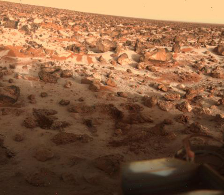
The Viking landers included weather stations that operated for several years, providing a perspective on martian weather. The temperatures they measured varied greatly with the seasons, due to the absence of moderating oceans and clouds. Typically, the summer maximum at Viking 1 was 240 K (–33 °C), dropping to 190 K (–83 °C) at the same location just before dawn. The lowest air temperatures, measured farther north by Viking 2, were about 173 K (–100 °C). During the winter, Viking 2 also photographed water frost deposits on the ground (Figure 10.22). We make a point of saying “water frost” here because at some locations on Mars, it gets cold enough for carbon dioxide (dry ice) to freeze out of the atmosphere as well.
英語のヒント
バイキング着陸機には、数年間動作した気象観測装置があり、火星の気象の様子を明らかにした。温度変化を和らげる海や雲がないため、測定した気温は季節によって大きく変わった。一般に、バイキング1号での夏の最高気温は240 K(−33℃)で、同じ場所でも夜明け直前には190 K(−83℃)まで下がった。さらに北のバイキング2号で測定された最低気温は、約173 K(−100℃)だった。冬にはバイキング2号が、地面に水の霜が堆積した様子も撮影した(図10.22)。ここであえて「水の霜」と言うのは、火星には、二酸化炭素も大気から凍り出して、ドライアイスになるほど寒くなる場所があるためだ。
Water Frost in Utopia.ユートピアの水の霜。
credit: NASA/JPL · JPL image use policy
Figure 10.22 This image of surface frost was photographed at the Viking 2 landing site during late winter. (credit: NASA/JPL)
図10.22 地表の霜のこの画像は、冬の終わりごろ、バイキング2号の着陸地点で撮影された。(提供:NASA/JPL)
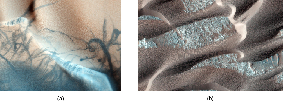
Most of the winds measured on Mars are only a few kilometers per hour. However, Mars is capable of great windstorms that can shroud the entire planet with windblown dust. Such high winds can strip the surface of some of its loose, fine dust, leaving the rock exposed. The later rovers found that each sunny afternoon the atmosphere became turbulent as heat rose off the surface. This turbulence generated dust devils, which play an important role in lifting the fine dust into the atmosphere. As the dust devils strip off the top layer of light dust and expose darker material underneath, they can produce fantastic patterns on the ground (Figure 10.23).
英語のヒント
火星で測られた風の大部分は、時速数kmにすぎない。しかし火星では、惑星全体を、風で巻き上げた塵で覆うほどの大きな嵐が起こりうる。このような強風は、表面から緩く積もった細かい塵の一部を取り去り、岩石を露出させる。後の探査車は、晴れた日の午後ごとに、表面から熱が上がるにつれて大気が乱れることを見いだした。この乱流は塵旋風を生み、細かな塵を大気中へ持ち上げる重要な役割を果たす。塵旋風は、明るい塵の上層を取り去って下の暗い物質を露出させるとき、地面に驚くような模様を作ることがある(図10.23)。
Wind on Mars plays an important role in redistributing surface material. Figure 10.23 shows a beautiful area of dark sand dunes on top of lighter material. Much of the material stripped out of the martian canyons has been dumped in extensive dune fields like this, mostly at high latitudes.
英語のヒント
火星の風は、表面の物質を別の場所へ運び直す重要な役割を果たす。図10.23は、明るい物質の上に暗い砂丘が広がる、美しい領域を示す。火星の峡谷から取り去られた物質の多くは、主に高緯度にある、このような広大な砂丘地帯に積もっている。
Dust Devil Tracks and Sand Dunes.塵旋風の跡と砂丘。
credit a: modification of work by NASA/JPL/University of Arizona; credit b: modification of work by NASA/JPL-Caltech/University of Arizona · JPL image use policy
Figure 10.23 (a) This high-resolution photo from the Mars Global Surveyor shows the dark tracks of several dust devils that have stripped away a thin coating of light-colored dust. This view is of an area about 3 kilometers across. Dust devils are one of the most important ways that dust gets redistributed by the martian winds. They may also help keep the solar panels of our rovers free of dust. (b) These windblown sand dunes on Mars overlay a lighter sandy surface. Each dune in this high-resolution view is about 1 kilometer across. (credit a: modification of work by NASA/JPL/University of Arizona; credit b: modification of work by NASA/JPL-Caltech/University of Arizona)
図10.23 (a)マーズ・グローバル・サーベイヤーによるこの高解像度写真には、明るい色の薄い塵の層を取り去った、いくつかの塵旋風の暗い跡が写っている。画像の幅は約3 kmである。塵旋風は、火星の風が塵を移動させ、分布を変える最も重要な仕組みの一つである。探査車の太陽電池パネルに塵がたまらないようにする働きもあるかもしれない。(b)火星の風でできた砂丘が、明るい砂地の上に重なっている。この高解像度画像に写る各砂丘の幅は、約1 kmである。(クレジット a:NASA/JPL/アリゾナ大学の作品を改変。b:NASA/JPL-Caltech/アリゾナ大学の作品を改変。)