第10章地球に似た惑星――金星と火星Earthlike Planets: Venus and Mars
Tectonic Activity地殻変動
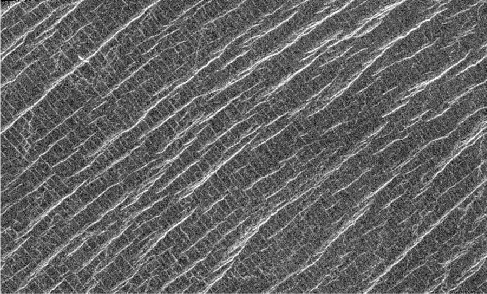
Convection currents of hot, slowly deforming rock in the mantle of Venus push and stretch the crust. Such forces are called tectonic, and the geological features that result from these forces are called tectonic features. On Venus’ lowland plains, tectonic forces have broken the lava surface to create remarkable patterns of ridges and cracks (Figure 10.10). In a few places, the crust has even torn apart to generate rift valleys. The circular features associated with coronae are tectonic ridges and cracks, and most of the mountains of Venus also owe their existence to tectonic forces.
英語のヒント
金星のマントル内にある、高温でゆっくり変形する岩石の対流は、地殻を押し、引き伸ばす。そのような力は地殻変動の力と呼ばれ、そこからできる地形は、構造地形と呼ばれる。金星の低地平原では、地殻変動の力が溶岩の表面を壊し、尾根と割れ目の印象的な模様を作った(図10.10)。一部の場所では、地殻が引き裂かれて地溝帯まで生まれた。コロナに伴う円形の特徴は、地殻変動による尾根や割れ目であり、金星の山々の大半も、そのような力によって存在している。
Ridges and Cracks.尾根と割れ目。
credit: modification of work by Magellan Team, JPL, NASA · JPL image use policy
Figure 10.10 This region of the Lakshmi Plains on Venus has been fractured by tectonic forces to produce a cross-hatched grid of cracks and ridges. Be sure to notice the fainter linear features that run perpendicular to the brighter ones. As this is a radar image, the brightness of the ridges indicates the strength of the radar echo, which depends on surface roughness, slope orientation, and material properties. This image shows a region about 80 kilometers wide and 37 kilometers high. Lakshmi is a Hindu goddess of prosperity. (credit: modification of work by Magellan Team, JPL, NASA)
図10.10 金星のラクシュミ平原のこの領域は、地殻変動の力で破砕され、割れ目と尾根が交差する格子模様を作っている。明るい線状地形と垂直に走る、より薄い線状地形にも必ず注目しよう。レーダー画像なので、尾根の明るさはレーダー反射の強さを示し、それは表面の粗さ、斜面の向き、物質の性質によって変わる。この画像の範囲は横約80 km、縦約37 kmである。ラクシュミは、ヒンドゥー教の繁栄の女神である。(提供:マゼランチーム、JPL、NASAの作品を改変)
The Ishtar continent, which has the highest elevations on Venus, is the most dramatic product of these tectonic forces. Ishtar and its tall Maxwell Mountains resemble the Tibetan Plateau and Himalayan Mountains on Earth. Both are the product of compression of the crust, and both are maintained by the continuing forces of mantle convection.
英語のヒント
金星で最も標高が高いイシュタル大陸は、これらの地殻変動の力が生んだ、最も壮観な結果である。イシュタルと高いマクスウェル山脈は、地球のチベット高原とヒマラヤ山脈に似ている。どちらも地殻の圧縮の産物であり、どちらも、マントルの対流が及ぼし続ける力によって維持されている。
On Venus’ Surface金星の表面で
The successful Venera landers of the 1970s and early 1980s found themselves on an extraordinarily inhospitable planet, with a surface pressure of 90 bars and a temperature hot enough to melt lead and zinc. Despite these unpleasant conditions, the spacecraft were able to photograph their surroundings and collect surface samples for chemical analysis before their instruments gave out. The diffuse sunlight striking the surface was tinted red by the clouds, and the illumination level was equivalent to a heavy overcast on Earth.
英語のヒント
1970年代から1980年代初めに着陸に成功したベネラ探査機は、きわめて過酷な惑星に到着した。表面の気圧は90 bar、温度は鉛や亜鉛を溶かすほど高かった。この厳しい条件にもかかわらず、探査機は機器が動かなくなる前に、周囲を撮影し、化学分析のために表面の試料を集めることができた。表面へ届く拡散した太陽光は雲によって赤く色づき、明るさは地球の厚い曇天と同程度だった。
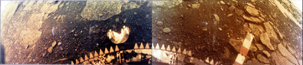
The probes found that the rock in the landing areas is igneous, primarily basalts. Examples of the Venera photographs are shown in Figure 10.11. Each picture shows a flat, desolate landscape with a variety of rocks, some of which may be ejecta from impacts. Other areas show flat, layered lava flows. There have been no further landings on Venus since the 1980s. However, NASA has plans for a radar orbiter with much higher resolution than Magellan, that will focus on the complex structures in the Aphrodite region. Some geologists think this area shows evidence of geologic plates, with past activity analogous to the plate tectonics on Earth.
英語のヒント
探査機は、着陸地点の岩石が火成岩で、主に玄武岩だと見いだした。ベネラの写真の例を図10.11に示す。それぞれに、さまざまな岩石のある、平坦で荒涼とした景色が写っている。岩石の一部は、衝突で放出されたものかもしれない。別の場所には、平坦で層状の溶岩流が見られる。1980年代以降、金星への新たな着陸はない。しかしNASAは、マゼランよりはるかに高い分解能を持ち、アフロディーテ地域の複雑な構造を重点的に調べる、レーダー周回機を計画している。一部の地質学者は、この領域が地殻プレートの証拠を示し、過去には地球のプレートテクトニクスに似た活動があったと考えている。
Surface of Venus.金星の表面。
credit: NASA · NASA media use guidelines
Figure 10.11 These views of the surface of Venus are from the Venera 13 spacecraft. Everything is orange because the thick atmosphere of Venus absorbs the bluer colors of light. The horizon is visible in the upper corner of each image. (credit: NASA)
図10.11 これらの金星表面の眺めは、ベネラ13号によるものである。金星の厚い大気が青みの強い光を吸収するため、すべてがオレンジ色になっている。各画像の上の隅に地平線が見える。(提供:NASA)
Key Concepts and Summary重要事項のまとめ
Venus has been mapped by radar, especially with the Magellan spacecraft. Its crust consists of 75% lowland lava plains, numerous volcanic features, and many large coronae, which are the expression of subsurface volcanism. The planet has been modified by widespread tectonics driven by mantle convection, forming complex patterns of ridges and cracks and building high continental regions such as Ishtar. The surface is extraordinarily inhospitable, with pressure of 90 bars and temperature of 730 K, but several Russian Venera landers investigated it successfully.
英語のヒント
金星はレーダー、特にマゼラン探査機によって地図化された。その地殻は、75%を占める低地の溶岩平原、多数の火山地形、そして地下の火成活動が表れた多くの大きなコロナからなる。マントル対流が駆動する広範な地殻変動によって、金星は姿を変え、複雑な尾根と割れ目の模様や、イシュタルのような高い大陸地域を作った。表面は90 barの気圧、730 Kの温度というきわめて過酷な環境だが、ロシアの複数のベネラ着陸機が、調査に成功した。
tectonic
地殻変動の
geological features that result from stresses and pressures in the crust of a planet; tectonic forces can lead to earthquakes and motion of the crust
惑星の地殻にかかる応力や圧力から生じる地形についていう。地殻変動の力は、地震や地殻の運動を引き起こしうる。