第10章地球に似た惑星――金星と火星Earthlike Planets: Venus and Mars
10.2 The Geology of Venus10.2 金星の地質
Learning Objectives学習の目標
By the end of this section, you will be able to:
この節を学び終えると、次のことができるようになる。
Describe the general features of the surface of Venus
金星表面の全般的な特徴を説明する。
Explain what the study of craters on Venus tells us about the age of its surface
金星のクレーター研究から、表面の年代について何がわかるかを説明する。
Compare tectonic activity and volcanoes on Venus with those of Earth
金星の地殻変動や火山を、地球のものと比較する。
Explain why the surface of Venus is inhospitable to human life
金星の表面が人間の生存に適さない理由を説明する。
Since Venus has about the same size and composition as Earth, we might expect its geology to be similar. This is partly true, but Venus does not exhibit the same kind of plate tectonics as Earth, and we will see that its lack of erosion results in a very different surface appearance.
英語のヒント
金星は大きさと組成が地球とほぼ同じなので、地質も似ていると予想できるかもしれない。これは部分的には正しいが、金星には地球と同じ種類のプレートテクトニクスが見られない。また、侵食がないため、表面の姿が大きく異なることも、これから見ていく。
Spacecraft Exploration of Venus宇宙機による金星探査
Nearly 50 spacecraft have been launched to Venus, but only about half were successful. Although the 1962 US Mariner 2 flyby was the first, the Soviet Union launched most of the subsequent missions to Venus. In 1970, Venera 7 became the first probe to land and broadcast data from the surface of Venus. It operated for 23 minutes before succumbing to the high surface temperature. Additional Venera probes and landers followed, photographing the surface and analyzing the atmosphere and soil.
英語のヒント
金星へは50機近い宇宙機が打ち上げられたが、成功したのは半数ほどだった。最初は1962年のアメリカのマリナー2号によるフライバイだったが、その後の金星ミッションの大部分を打ち上げたのはソ連である。1970年、ベネラ7号は、金星の表面に着陸してデータを送った初の探査機となった。23分間動作した後、表面の高温に耐えられなくなった。その後もベネラの探査機や着陸機が続き、表面を撮影し、大気と土壌を分析した。
To understand the geology of Venus, however, we needed to make a global study of its surface, a task made very difficult by the perpetual cloud layers surrounding the planet. The problem resembles the challenge facing air traffic controllers at an airport, when the weather is so cloudy or smoggy that they can’t locate the incoming planes visually. The solution is similar in both cases: use a radar instrument to probe through the obscuring layer.
英語のヒント
しかし、金星の地質を理解するには、表面を全球にわたって調べる必要があった。惑星を取り囲む恒久的な雲の層が、この作業を非常に難しくしていた。この問題は、雲やスモッグが濃く、近づく飛行機を目で確認できないときに、空港の航空管制官が直面する難題に似ている。解決法も両者で同じで、視界を遮る層の向こうを、レーダー装置で探るのである。
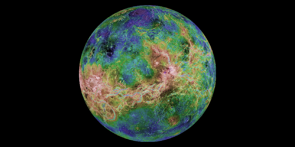
The first global radar map was made by the US Pioneer Venus orbiter in the late 1970s, followed by better maps from the twin Soviet Venera 15 and 16 radar orbiters in the early 1980s. However, most of our information on the geology of Venus is derived from the US Magellan spacecraft, which mapped Venus with a powerful imaging radar. Magellan produced images with a resolution of 100 meters, much better than that of previous missions, yielding our first detailed look at the surface of our sister planet (Figure 10.6). (The Magellan spacecraft returned more data to Earth than all previous planetary missions combined; each 100 minutes of data transmission from the spacecraft provided enough information, if translated into characters, to fill two 30-volume encyclopedias.)
英語のヒント
最初の全球レーダー地図は、1970年代後半、アメリカのパイオニア・ビーナス周回機によって作られた。続いて、1980年代初めには、ソ連の2機のレーダー周回機ベネラ15号・16号によって、より優れた地図が得られた。しかし、金星の地質についての情報の大部分は、強力な画像レーダーで金星を地図化した、アメリカのマゼラン探査機から得られている。マゼランは、過去のミッションよりはるかに優れた100 mの分解能の画像を作り、私たちの姉妹惑星の表面を、初めて詳しく見せてくれた(図10.6)。マゼランが地球へ送ったデータ量は、それ以前の惑星探査ミッションすべてを合わせた量を上回った。探査機が100分間に送るデータだけでも、文字に直せば、30巻組の百科事典を2組埋めるほどの情報量があった。
Radar Map of Venus.金星のレーダー地図。
credit: modification of work by NASA/JPL/USGS · JPL image use policy
Figure 10.6 This composite image has a resolution of about 3 kilometers. Colors have been added to indicate elevation, with blue meaning low and brown and white high. The large continent Aphrodite stretches around the equator, where the bright (therefore rough) surface has been deformed by tectonic forces in the crust of Venus. (credit: modification of work by NASA/JPL/USGS)
図10.6 この合成画像の分解能は約3 kmである。標高を示すために色が加えられ、青は低い場所、茶と白は高い場所を意味する。大きなアフロディーテ大陸は赤道に沿って延び、その明るい、つまり起伏の激しい表面は、金星の地殻内の地殻変動の力によって変形している。(提供:NASA/JPL/USGSの作品を改変)
Consider for a moment how good Magellan’s resolution of 100 meters really is. It means the radar images from Venus can show anything on the surface larger than a football field. Suddenly, a whole host of topographic features on Venus became accessible to our view. As you look at the radar images throughout this chapter, bear in mind that these are constructed from radar reflections, not from visible-light photographs. For example, bright features on these radar images are an indication of rough terrain, whereas darker regions are smoother.
英語のヒント
マゼランの100 mという分解能が、実際にどれほど優れているか、少し考えよう。金星のレーダー画像では、フットボールの競技場より大きい表面の物体が、どれでも見えるということだ。突然、金星の多種多様な地形を見られるようになったのである。この章のレーダー画像を見るときには、可視光の写真ではなく、レーダーの反射から作られていることを覚えておこう。たとえば、レーダー画像の明るい部分は、起伏の激しい地形を示し、暗い領域ほど滑らかである。
Probing Through the Clouds of Venus金星の雲を通して探る
The radar maps of Venus reveal a planet that looks much the way Earth might look if our planet’s surface were not constantly being changed by erosion and deposition of sediment. Because there is no water or ice on Venus and the surface wind speeds are low, almost nothing obscures or erases the complex geological features produced by the movements of Venus’ crust, by volcanic eruptions, and by impact craters. Having finally penetrated below the clouds of Venus, we find its surface to be naked, revealing the history of hundreds of millions of years of geological activity.
英語のヒント
金星のレーダー地図に現れたのは、もし地球の表面が侵食や堆積物の堆積によって絶えず変えられていなければ、地球もこう見えるかもしれない、と思わせる惑星だった。金星には水も氷もなく、地表の風速も小さいため、地殻の動き、火山噴火、衝突クレーターが作った複雑な地形を、隠したり消したりするものがほぼない。ついに金星の雲の下まで見通せるようになると、そこにはむき出しの表面があり、何億年にもわたる地質活動の歴史が現れた。
About 75% of the surface of Venus consists of lowland lava plains. Superficially, these plains resemble the basaltic ocean basins of Earth, but they were not produced in quite the same way. There is no evidence of subduction zones on Venus, indicating that, unlike Earth, this planet never experienced plate tectonics. Although convection (the rising of hot materials) in its mantle generated great stresses in the crust of Venus, they did not start large continental plates moving. The formation of the lava plains of Venus more nearly resembles that of the lunar maria. Both were the result of widespread lava eruptions without the crustal spreading associated with plate tectonics.
英語のヒント
金星の表面の約75%は、低地の溶岩平原からなる。これらの平原は、表面的には地球の玄武岩質の海盆に似ているが、形成の仕方はまったく同じではない。金星には沈み込み帯の証拠がなく、この惑星が地球と違って、プレートテクトニクスを経験しなかったことを示している。マントル内の対流、つまり熱い物質の上昇は、金星の地殻に大きな応力を生んだものの、大きな大陸プレートを動かし始めることはなかった。金星の溶岩平原の形成は、むしろ月の海の形成に似ている。どちらも、プレートテクトニクスに伴う地殻の拡大を伴わずに起きた、広範な溶岩噴出の結果だった。
Rising above the lowland lava plains are two full-scale continents of mountainous terrain. The largest continent on Venus, called Aphrodite, is about the size of Africa (you can see it stand out in Figure 10.6). Aphrodite stretches along the equator for about one-third of the way around the planet. Next in size is the northern highland region Ishtar, which is about the size of Australia. Ishtar contains the highest region on the planet, the Maxwell Mountains, which rise 11 kilometers above the surrounding lowlands. (The Maxwell Mountains are the only feature on Venus named after a man. They commemorate James Clerk Maxwell, whose theory of electromagnetism led to the invention of radar. All other features are named for women, either from history or mythology.)
英語のヒント
低地の溶岩平原より上にそびえるのは、山がちな地形からなる、二つの本格的な大陸である。最大のアフロディーテ大陸は、アフリカほどの大きさを持つ。図10.6では、そこがはっきり浮かび上がって見える。アフロディーテは赤道に沿って、惑星の全周の約3分の1にわたって延びている。次に大きいのは、北部の高地イシュタルで、オーストラリアほどの広さである。イシュタルには、惑星で最も高い領域のマクスウェル山脈があり、周囲の低地から11 kmそびえている。マクスウェル山脈は、金星で唯一、男性にちなんだ名前を持つ地形である。電磁気学の理論がレーダーの発明につながった、ジェームズ・クラーク・マクスウェルを記念するものだ。ほかの地形はすべて、歴史上または神話上の女性にちなんでいる。