第4章地球・月・空Earth, Moon, and Sky
4.1 Earth and Sky4.1 地球と空
Learning Objectives学習の目標
By the end of this section, you will be able to:
この節を学ぶと、次のことができるようになる。
Describe how latitude and longitude are used to map Earth
地球上の位置を表すために緯度と経度がどのように使われるかを説明する。
Explain how right ascension and declination are used to map the sky
空の位置を表すために赤経と赤緯がどのように使われるかを説明する。
In order to create an accurate map, a mapmaker needs a way to uniquely and simply identify the location of all the major features on the map, such as cities or natural landmarks. Similarly, astronomical mapmakers need a way to uniquely and simply identify the location of stars, galaxies, and other celestial objects. On Earth maps, we divide the surface of Earth into a grid, and each location on that grid can easily be found using its latitude and longitude coordinate. Astronomers have a similar system for objects on the sky. Learning about these can help us understand the apparent motion of objects in the sky from various places on Earth.
英語のヒント
正確な地図を作るには、都市や自然の目印など、地図に載る主要なものすべての位置を、一意に、しかも簡単に指定する方法が必要である。同じように、天体の地図を作る人にも、恒星や銀河などの天体の位置を一意に、簡単に指定する方法が必要になる。地球の地図では、地表を格子に区切り、その格子上の各地点を緯度と経度という座標で簡単に見つけられるようにする。天文学者も、空にある天体に同様の仕組みを使っている。これらを学べば、地球上のさまざまな場所から見た天体の見かけの動きも理解しやすくなる。
Locating Places on Earth地球上の位置を指定する
Let’s begin by fixing our position on the surface of planet Earth. As we discussed in Observing the Sky: The Birth of Astronomy, Earth’s axis of rotation defines the locations of its North and South Poles and of its equator, halfway between. Two other directions are also defined by Earth’s motions: east is the direction toward which Earth rotates, and west is its opposite. At almost any point on Earth, the four directions—north, south, east, and west—are well defined, despite the fact that our planet is round rather than flat. The only exceptions are exactly at the North and South Poles, where the directions east and west are ambiguous (because points exactly at the poles do not turn).
英語のヒント
まず、地球の表面における自分の位置を定めよう。「空を観測する――天文学の誕生」で説明したように、地球の自転軸によって北極と南極の位置が定まり、その中間に赤道が定まる。東と西という二つの方角も、地球の運動で定まる。地球が自転する向きが東で、その反対が西である。地球は平面ではなく球形だが、ほぼどの地点でも東西南北の四つの方角は明確に定まる。例外は北極点と南極点の真上だけで、そこでは東西の向きがあいまいになる。極点そのものは、自転しても円を描いて移動しないからである。
We can use these ideas to define a system of coordinates attached to our planet. Such a system, like the layout of streets and avenues in Manhattan or Salt Lake City, helps us find where we are or want to go. Coordinates on a sphere, however, are a little more complicated than those on a flat surface. We must define circles on the sphere that play the same role as the rectangular grid that you see on city maps.
英語のヒント
この考え方を使って、地球に固定した座標系を定めることができる。このような座標系は、マンハッタンやソルトレークシティの縦横の街路と同じように、自分が今いる場所や行きたい場所を見つける助けになる。ただし、球面上の座標は平面上の座標より少し複雑である。市街地図に見られる長方形の格子と同じ役割を果たす円を、球面上に定めなければならない。
A great circle is any circle on the surface of a sphere whose center is at the center of the sphere. For example, Earth’s equator is a great circle on Earth’s surface, halfway between the North and South Poles. We can also imagine a series of great circles that pass through both the North and South Poles. Each of the circles is called a meridian; they are each perpendicular to the equator, crossing it at right angles.
英語のヒント
大円とは、球面上にある円のうち、その中心が球の中心と一致するものをいう。たとえば地球の赤道は、北極と南極の中間にある、地球表面の大円である。北極と南極の両方を通る大円を、いくつも考えることもできる。これらの円をそれぞれ子午線と呼ぶ。どの子午線も赤道に垂直で、赤道と直角に交わる。
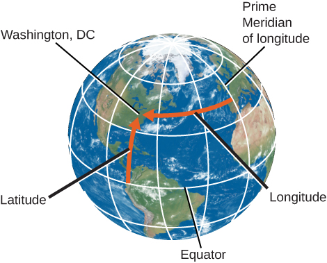
Any point on the surface of Earth will have a meridian passing through it (Figure 4.2). The meridian specifies the east-west location, or longitude, of the place. By international agreement (and it took many meetings for the world’s countries to agree), longitude is defined as the number of degrees of arc along the equator between your meridian and the one passing through Greenwich, England, which has been designated as the Prime Meridian. The longitude of the Prime Meridian is defined as 0°.
英語のヒント
地球の表面のどの地点にも、そこを通る子午線がある(図4.2)。その子午線が、その場所の東西方向の位置、すなわち経度を指定する。国際的な合意により、経度は、その地点の子午線とイギリスのグリニッジを通る子午線との間を赤道に沿って測った弧の角度、と定められている。世界の国々が合意するまでには、何度も会議を重ねる必要があった。グリニッジを通る子午線は本初子午線に指定され、その経度を0°と定義する。
Latitude and Longitude of Washington, DC.ワシントンD.C.の緯度と経度。
OpenStax / Rice University · CC BY 4.0
Figure 4.2 We use latitude and longitude to find cities like Washington, DC, on a globe. Latitude is the number of degrees north or south of the equator, and longitude is the number of degrees east or west of the Prime Meridian. Washington, DC’s coordinates are 38° N and 77° W.
図4.2 地球儀上でワシントンD.C.のような都市を探すには、緯度と経度を使う。緯度は赤道から北または南へ何度離れているか、経度は本初子午線から東または西へ何度離れているかを表す。ワシントンD.C.の座標は北緯38°、西経77°である。
Why Greenwich, you might ask? Every country wanted 0° longitude to pass through its own capital. Greenwich, the site of the old Royal Observatory (Figure 4.3), was selected because it was between continental Europe and the United States, and because it was the site for much of the development of the method to measure longitude at sea. Longitudes are measured either to the east or to the west of the Greenwich meridian from 0° to 180°. As an example, the longitude of the clock-house benchmark of the U.S. Naval Observatory in Washington, DC, is 77.066° W.
英語のヒント
なぜグリニッジなのか、と疑問に思うかもしれない。どの国も、自国の首都を経度0°の線が通ることを望んでいた。旧王立天文台のあるグリニッジ(図4.3)が選ばれたのは、ヨーロッパ大陸とアメリカの間に位置していたこと、そして海上で経度を測定する方法の開発が、そこで盛んに進められたことによる。経度は、グリニッジの子午線から東向きまたは西向きに、0°から180°まで測る。たとえば、ワシントンD.C.のアメリカ海軍天文台にある時計室の基準点の経度は、西経77.066°である。
Royal Observatory in Greenwich, England.イギリス、グリニッジの王立天文台。
Figure 4.3 At the internationally agreed-upon zero point of longitude at the Royal Observatory Greenwich, tourists can stand and straddle the exact line where longitude “begins.”(credit left: modification of work by “pdbreen”/Flickr; credit right: modification of work by Ben Sutherland)
図4.3 グリニッジ王立天文台にある、国際的な合意で定められた経度の原点。観光客は、経度が「始まる」その線をまたいで立つことができる。(左の出典:「pdbreen」/Flickrの作品を改変。右の出典:Ben Sutherlandの作品を改変)
Your latitude (or north-south location) is the number of degrees of arc you are away from the equator along your meridian. Latitudes are measured either north or south of the equator from 0° to 90°. (The latitude of the equator is 0°.) As an example, the latitude of the previously mentioned Naval Observatory benchmark is 38.921° N. The latitude of the South Pole is 90° S, and the latitude of the North Pole is 90° N.
英語のヒント
緯度、すなわち南北方向の位置は、その地点の子午線に沿って、赤道から何度の弧だけ離れているかを表す。緯度は赤道から北向きまたは南向きに、0°から90°まで測る。赤道の緯度は0°である。たとえば、先ほどの海軍天文台の基準点は北緯38.921°にある。南極の緯度は南緯90°、北極の緯度は北緯90°である。
Locating Places in the Sky空の位置を指定する
Positions in the sky are measured in a way that is very similar to the way we measure positions on the surface of Earth. Instead of latitude and longitude, however, astronomers use coordinates called declination and right ascension. To denote positions of objects in the sky, it is often convenient to make use of the fictitious celestial sphere. We saw in Observing the Sky: The Birth of Astronomy that the sky appears to rotate about points above the North and South Poles of Earth—points in the sky called the north celestial pole and the south celestial pole. Halfway between the celestial poles, and thus 90° from each pole, is the celestial equator, a great circle on the celestial sphere that is in the same plane as Earth’s equator. We can use these markers in the sky to set up a system of celestial coordinates.
英語のヒント
空の位置は、地球表面の位置を測るのとよく似た方法で測る。ただし、緯度と経度の代わりに、天文学者は赤緯と赤経という座標を使う。天体の位置を表すには、仮想的な天球を利用すると便利なことが多い。「空を観測する――天文学の誕生」では、空が地球の北極と南極の上方にある点を中心に回転して見えることを学んだ。この空の二つの点を、それぞれ天の北極、天の南極という。両方の天の極の中間、つまりそれぞれの極から90°離れたところに天の赤道がある。これは地球の赤道と同じ平面にある、天球上の大円である。これらの目印を使って、天球の座標系を定められる。
Declination on the celestial sphere is measured the same way that latitude is measured on the sphere of Earth: from the celestial equator toward the north (positive) or south (negative). So Polaris, the star near the north celestial pole, has a declination of almost +90°.
天球上の赤緯は、地球上の緯度と同じように、天の赤道から北向き、または南向きに測る。北向きを正、南向きを負とする。したがって、天の北極近くにある北極星ポラリスの赤緯は、ほぼ+90°である。
Right ascension (RA) is like longitude, except that instead of Greenwich, the arbitrarily chosen point where we start counting is the vernal equinox, a point in the sky where the ecliptic (the Sun’s path) crosses the celestial equator. RA can be expressed either in units of angle (degrees) or in units of time. This is because the celestial sphere appears to turn around Earth once a day as our planet turns on its axis. Thus the 360° of RA that it takes to go once around the celestial sphere can just as well be set equal to 24 hours. Then each 15° of arc is equal to 1 hour of time. For example, the approximate celestial coordinates of the bright star Capella are RA and declination .
英語のヒント
赤経(RA)は経度に似ている。ただし、グリニッジの代わりに、数え始める基準点として春分点を選ぶ。春分点は、黄道、つまり太陽の通り道が天の赤道と交わる、空の上の点である。赤経は角度の単位である度でも、時間の単位でも表せる。地球が地軸の周りを自転すると、天球が地球の周りを1日に1回転するように見えるためである。そのため、天球をひと回りする赤経360°を、24時間と等しく置いてもよい。すると弧の15°が、時間の1時間に相当する。たとえば、明るい星カペラのおよその天球座標は、赤経、赤緯である。
One way to visualize these circles in the sky is to imagine Earth as a transparent sphere with the terrestrial coordinates (latitude and longitude) painted on it with dark paint. Imagine the celestial sphere around us as a giant ball, painted white on the inside. Then imagine yourself at the center of Earth, with a bright light bulb in the middle, looking out through its transparent surface to the sky. The terrestrial poles, equator, and meridians will be projected as dark shadows on the celestial sphere, giving us the system of coordinates in the sky.
英語のヒント
空の上のこれらの円を思い描くには、地球を透明な球と考え、その表面に地球の座標である緯度・経度の線を濃い絵の具で描いてみるとよい。自分たちを取り囲む天球は、内側を白く塗った巨大な球と想像する。次に、自分が地球の中心にいて、そこに明るい電球があり、透明な地表を通して空を見ているところを考えよう。地球の両極、赤道、子午線は、天球の上に暗い影として投影される。それが、空の座標系を与えてくれる。