第12章環・衛星・冥王星Rings, Moons, and Pluto
The Nature of Pluto冥王星の性質
Almost everything we know about Pluto and its moons comes from the New Horizons spacecraft, which flew by in 2015 before traveling on into the outermost parts of the planetary system. Using data from the New Horizons probe, astronomers have measured the diameter of Pluto as 2370 kilometers, only 60 percent as large as our Moon. From the diameter and mass, we find a density of 1.9 g/cm3, suggesting that Pluto is a mixture of rocky materials and water ice in about the same proportions as many outer-planet moons.
英語のヒント
冥王星とその衛星について私たちが知ることのほぼすべては、ニュー・ホライズンズから得られた。この探査機は2015年にそばを通過し、その後、惑星系の最も外側へ向かった。そのデータを用いて、天文学者は冥王星の直径を2370キロメートル、地球の月のわずか60%と測定した。直径と質量から求めた密度は1.9 g/cm³であり、冥王星は、外惑星の多くの衛星とほぼ同じ割合の、岩石物質と水の氷の混合物だと示している。
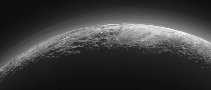
Parts of Pluto’s surface are highly reflective, and its spectrum demonstrates the presence on its surface of frozen methane, carbon monoxide, and nitrogen. The maximum surface temperature ranges from about 50 K when Pluto is farthest from the Sun to 60 K when it is closest. Even this small difference is enough to cause a partial sublimation (going from solid to gas) of the methane and nitrogen ice. This generates an atmosphere when Pluto is close to the Sun, and it freezes out when Pluto is farther away. Observations of distant stars seen through this thin atmosphere indicate that the surface pressure is about a ten-thousandth of Earth’s. Because Pluto is a few degrees warmer than Triton, its atmospheric pressure is about ten times greater. This atmosphere contains several distinct haze layers, presumably caused by photochemical reactions, like those in Titan’s atmosphere (Figure 12.20).
英語のヒント
冥王星表面の一部は反射率が非常に高く、スペクトルから、表面に凍ったメタン、一酸化炭素、窒素が存在するとわかる。表面の最高温度は、太陽から最も遠いときの約50 Kから、最も近いときの60 Kまで変化する。この小さな差でも、メタンと窒素の氷の一部を、固体から気体へと昇華させるには十分である。太陽に近いときにはこれが大気を作り、遠ざかると再び凍って大気から取り除かれる。薄い大気を透かして見た遠方の恒星の観測から、地表の気圧は地球の約1万分の1だと示されている。冥王星はトリトンより数度温かいため、大気圧は約10倍高い。大気にははっきりしたもやの層がいくつもある。おそらく、タイタン大気のものと同様、光化学反応によって生じるのだろう(図12.20)。
Haze Layers in the Atmosphere of Pluto.冥王星の大気のもやの層。
credit: modification of work by NASA/Johns Hopkins University Applied Physics Laboratory/Southwest Research Institute · NASA media use guidelines
Figure 12.20 This is one of the highest-resolution photos of Pluto, taken by the New Horizons spacecraft 15 minutes after its closest approach. It shows 12 layers of haze. Note also the range of mountains with heights up to 3500 meters. (credit: modification of work by NASA/Johns Hopkins University Applied Physics Laboratory/Southwest Research Institute)
図12.20 ニュー・ホライズンズが最接近の15分後に撮影した、冥王星の最高解像度の写真の一つ。12層のもやが見える。高さ3500メートルに達する山脈にも注目しよう。(クレジット:NASA/Johns Hopkins University Applied Physics Laboratory/Southwest Research Instituteの作品を改変)
Reaching Pluto with a spacecraft was a major challenge, especially in an era when reduced NASA budgets could not support large, expensive missions like Galileo and Cassini. Yet like Galileo and Cassini, a Pluto mission would require a nuclear electric system that used the heat from plutonium to generate the energy to power the instruments and keep them operating far from the warmth of the Sun. NASA made available one of the last of its nuclear generators for such a mission. Assuming an affordable but highly capable spacecraft could be built, there was still the problem of getting to Pluto, nearly 5 billion kilometers from Earth, without waiting decades. The answer was to use Jupiter’s gravity to slingshot the spacecraft toward Pluto.
英語のヒント
探査機を冥王星へ到達させるのは大きな難題だった。特にNASAの予算が減り、ガリレオやカッシーニのような大規模で高価な探査を支えられない時代には、なおさらである。それでも両探査機と同様、冥王星探査には、太陽の暖かさから遠く離れても機器に電力を与え、動作を保てる、原子力電源が必要だった。これはプルトニウムからの熱を使って電力を生むものである。NASAは、残り少なくなっていた原子力発電装置の一つを、この探査に使えるようにした。手頃な費用で高性能の探査機を作れるとしても、地球からほぼ50億キロメートル離れた冥王星に、何十年も待たずに着く問題が残った。答えは、木星の重力を使って探査機を冥王星へ投げ飛ばすことだった。
The 2006 launch of New Horizons started the mission with a high speed, and the Jupiter flyby just a year later gave it the required additional boost. The New Horizons spacecraft arrived at Pluto in July 2015, traveling at a relative speed of 14 kilometers per second (or about 50,000 kilometers per hour). With this high speed, the entire flyby sequence was compressed into just one day. Most of the data recorded near closest approach could not be transmitted to Earth until many months later, but when it finally arrived, astronomers were rewarded with a treasure trove of images and data.
英語のヒント
2006年の打ち上げで、ニュー・ホライズンズは高速で旅を始め、わずか1年後の木星フライバイで、必要な追加の加速を得た。2015年7月に冥王星へ到着したときの相対速度は、毎秒14キロメートル、時速約5万キロメートルだった。この高速のため、フライバイの全行程はわずか1日に詰め込まれた。最接近付近で記録したデータの大半は、何か月も後まで地球へ送れなかった。しかし、ついに届くと、天文学者には画像とデータの宝の山という報酬が待っていた。
Geology of Pluto冥王星の地質
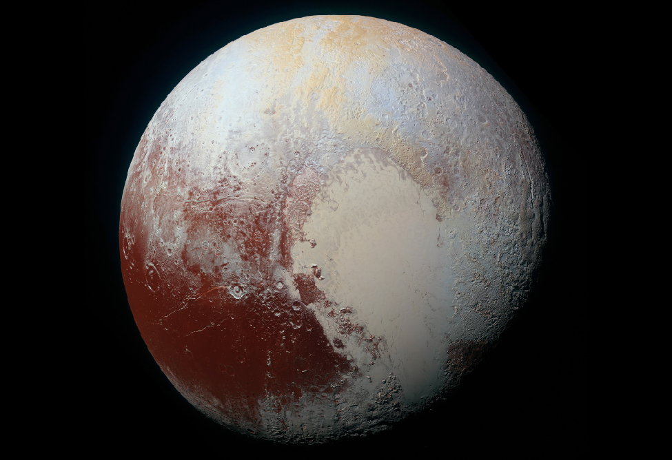
Pluto is not the geologically dead world that many anticipated for such a small object—far from it. The division of the surface into areas with different composition and surface texture is apparent in the global color photo shown in Figure 12.21. The reddish color is enhanced in this image to bring out differences in color more clearly. The darker parts of the surface are cratered, but adjacent to them is a nearly featureless light area in the lower right quadrant of this image. This is a huge ice-filled depression called the Sputnik Plains, named for the first artificial Earth satellite. The absence of impact craters suggests a surface no more than 10 million years old. The dark areas show the colors of photochemical haze or smog similar to that in the atmosphere of Titan. The dark material that is staining these old surfaces could come from Pluto’s atmospheric haze or from chemical reactions taking place at the surface due to the action of sunlight.
英語のヒント
冥王星は、小さな天体だからと多くの人が予想していた、地質学的に死んだ世界ではない。それどころではなかった。図12.21の全球カラー写真には、組成と表面の質感が異なる領域への分かれ方が、はっきり表れている。この画像では、色の違いを見やすくするため赤みを強調している。表面の暗い部分はクレーターに覆われているが、その隣の画像右下には、ほとんど模様のない明るい領域がある。これは氷で満たされた巨大なくぼみで、最初の地球の人工衛星にちなんで、スプートニク平原と呼ばれる。衝突クレーターがないことは、表面が古くても1000万年前のものだと示す。暗い領域は、タイタン大気のものに似た光化学性のもややスモッグの色を示す。古い表面を染める暗い物質は、冥王星大気のもやから来たのかもしれないし、太陽光の作用で表面に起こる化学反応によってできたのかもしれない。
Global Color Image of Pluto.冥王星の全球カラー画像。
credit: modification of work by NASA/Johns Hopkins University Applied Physics Laboratory/Southwest Research Institute · NASA media use guidelines
Figure 12.21 This New Horizons image clearly shows the variety of terrains on Pluto. The dark area in the lower left is covered with impact craters, while the large light area in the center and lower right is a flat basin devoid of craters. The colors you see are somewhat enhanced to bring out subtle differences. (credit: modification of work by NASA/Johns Hopkins University Applied Physics Laboratory/Southwest Research Institute)
図12.21 ニュー・ホライズンズのこの画像は、冥王星の地形の多様さをはっきり示している。左下の暗い領域は衝突クレーターに覆われるが、中央と右下の大きな明るい領域は、クレーターのない平坦な盆地である。微妙な違いを浮かび上がらせるため、色は少し強調している。(クレジット:NASA/Johns Hopkins University Applied Physics Laboratory/Southwest Research Instituteの作品を改変)
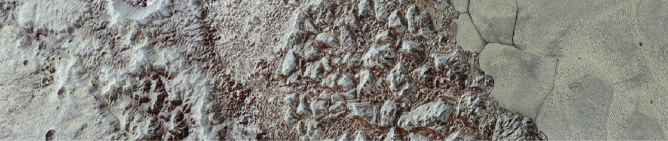
Figure 12.22 shows some of the remarkable variety of surface features New Horizons revealed. Toward the right on this image, we see the shoreline of the Sputnik Plains, showing evidence of relatively recent geological activity. The nitrogen and carbon monoxide ice that fills the Sputnik depression shows cells or polygons with an average width of more than 30 kilometers, caused by slow convection in the ice.In the process of convection, warmer material rises and colder material sinks, transferring energy. You are probably more familiar with convection in warm fluids, like the cells you see when you are heating some kinds of soup, but it can also happen (very slowly) in colder substances.
英語のヒント
図12.22は、ニュー・ホライズンズが明らかにした驚くほど多様な表面の特徴の一部を示す。画像の右側にはスプートニク平原の「岸」が見え、比較的最近の地質活動の証拠がある。スプートニクのくぼみを満たす窒素と一酸化炭素の氷には、平均の幅が30キロメートルを超えるセル、または多角形が見える。氷の中のゆっくりした対流によってできたものである。対流では、温かい物質が上昇し、冷たい物質が下降して、エネルギーを運ぶ。スープを温めたときに見えるセルのように、温かい流体の対流の方がなじみ深いだろうが、低温の物質でも、非常にゆっくりとなら起こる。
Diversity of Terrain on Pluto.冥王星の地形の多様性。
credit: modification of work by NASA/Johns Hopkins University Applied Physics Laboratory/Southwest Research Institute · NASA media use guidelines
Figure 12.22 This enhanced color view of a strip of Pluto’s surface about 80 kilometers long shows a variety of different surface features. From left to right, we first cross a region of “badlands” with some craters showing, and then move across a wide range of mountains made of water ice and coated with the redder material we saw in the previous image. Then, at right, we arrive at the “shoreline” of the great sea of frozen nitrogen that the mission scientists have named the “Sputnik Plains.” This nitrogen sea is divided into mysterious cells or segments that are many kilometers across. (credit: modification of work by NASA/Johns Hopkins University Applied Physics Laboratory/Southwest Research Institute)
図12.22 長さ約80キロメートルの冥王星表面の帯状の領域を、色を強調して示した画像。さまざまな表面の特徴が見える。左から右へ進むと、まずいくつかのクレーターが見える「荒地」を横切り、次に水の氷でできた広い山脈を越える。山々は前の画像でも見た、より赤い物質に覆われている。右では、探査の科学者たちが「スプートニク平原」と名づけた、凍った窒素の大海の「海岸線」に着く。この窒素の海は、幅が何キロメートルもある謎めいたセルや区画に分かれている。(クレジット:NASA/Johns Hopkins University Applied Physics Laboratory/Southwest Research Instituteの作品を改変)
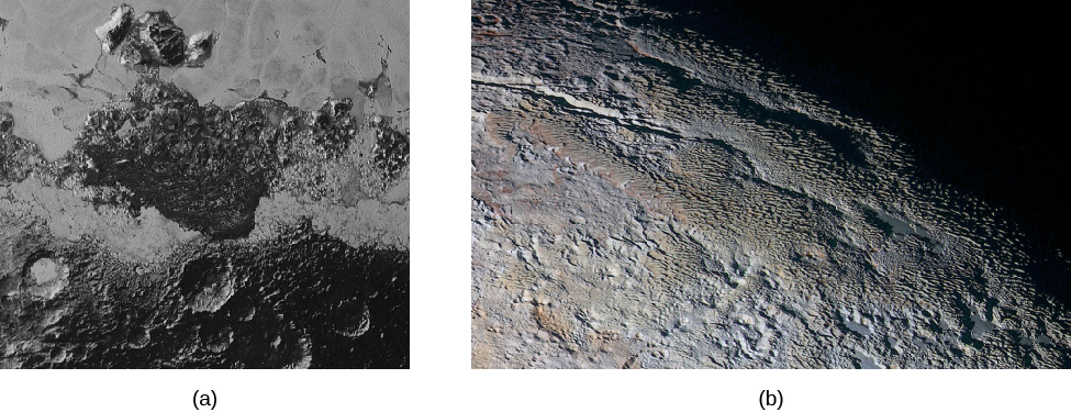
Figure 12.23 shows another view of the boundary between different types of geology. The width of this image is 250 kilometers, and it shows dark, ancient, heavily cratered terrain; dark, uncratered terrain with a hilly surface; smooth, geologically young terrain; and a small cluster of mountains more than 3000 meters high. In the best images, the light areas of nitrogen ice seem to have flowed much like glaciers on Earth, covering some of the older terrain underneath them.
英語のヒント
図12.23は、地質の異なる領域の境界を別の角度から示す。画像の幅は250キロメートルで、暗く古くクレーターが密集する地形、暗いがクレーターのない丘陵地、滑らかで地質学的に若い地形、高さ3000メートルを超える小さな山塊が見える。最良の画像では、明るい窒素氷の領域が、地球の氷河のように流れ、その下の古い地形の一部を覆ったように見える。
The isolated mountains in the midst of the smooth nitrogen plains are probably also made of water ice, which is very hard at the temperatures on Pluto and can float on frozen nitrogen. Additional mountains, and some hilly terrain that reminded the mission scientists of snakeskin, are visible in part (b) of Figure 12.23.
英語のヒント
滑らかな窒素平原の中に孤立する山々も、おそらく水の氷でできている。水の氷は冥王星の温度では非常に硬く、凍った窒素の上に浮くことができる。図12.23(b)には、ほかの山々と、探査の科学者にヘビの皮を思い出させた丘陵地の一部が見える。
Diversity of Terrains on Pluto.冥王星の多様な地形。
credit a, b: modification of work by NASA/Johns Hopkins University Applied Physics Laboratory/Southwest Research Institute · NASA media use guidelines
Figure 12.23 (a) In this photo, about 250 kilometers across, we can see many different kinds of terrain. At the bottom are older, cratered highlands; a V-shaped region of hills without cratering points toward the bottom of the image. Surrounding the V-shaped dark region is the smooth, brighter frozen nitrogen plain, acting as glaciers on Earth do. Some isolated mountains, made of frozen water ice, are floating in the nitrogen near the top of the picture. (b) This scene is about 390 kilometers across. The rounded mountains, quite different from those we know on Earth, are named Tartarus Dorsa. The patterns, made of repeating ridges with the more reddish terrain between them, are not yet understood. (credit a, b: modification of work by NASA/Johns Hopkins University Applied Physics Laboratory/Southwest Research Institute)
図12.23 (a)幅約250キロメートルの写真に、さまざまな地形が見える。下には古いクレーターに覆われた高地がある。クレーターのない丘陵地はV字形をなし、画像の下へ向かっている。V字形の暗い領域を囲むのは、地球の氷河のように振る舞う、滑らかで明るい凍結窒素の平原である。画像上部付近の窒素の中には、凍った水の氷でできた孤立した山々が浮いている。(b)この領域の幅は約390キロメートル。地球で見慣れた山とは大きく違う、丸みを帯びた山々は、タルタロス山地と名づけられた。尾根が繰り返し並び、その間により赤い地形があるという模様は、まだ理解されていない。(クレジットa・b:NASA/Johns Hopkins University Applied Physics Laboratory/Southwest Research Instituteの作品を改変)