第8章惑星としての地球Earth as a Planet
Rift and Subduction Zonesリフト帯と沈み込み帯
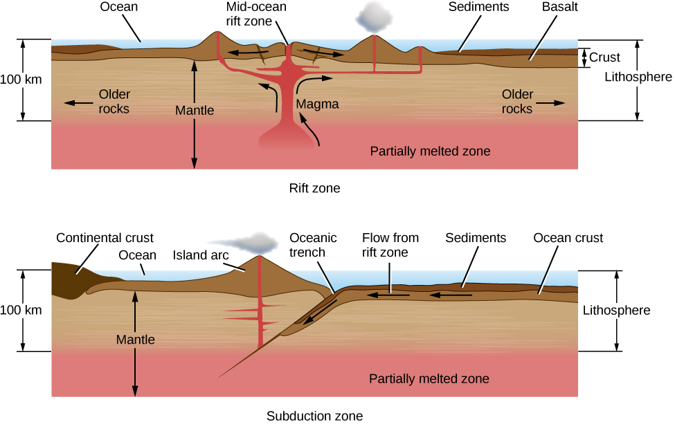
Plates pull apart from each other along rift zones, such as the Mid-Atlantic ridge, driven by upwelling currents in the mantle (Figure 8.9). A few rift zones are found on land. The best known is the central African rift—an area where the African continent is slowly breaking apart. Most rift zones, however, are in the oceans. Molten rock rises from below to fill the space between the receding plates; this rock is basaltic lava, the kind of igneous rock that forms most of the ocean basins.
英語のヒント
大西洋中央海嶺のようなリフト帯に沿って、プレートは互いに離れていく。その動力は、マントル内で上昇する流れである(図8.9)。陸上にも、いくつかのリフト帯がある。最もよく知られるのは、アフリカ大陸がゆっくり引き裂かれつつある、アフリカ中央部のリフトだ。しかし、リフト帯の大半は海の中にある。離れていくプレートの間を埋めるため、溶けた岩石が下から上がってくる。この岩石は玄武岩質の溶岩で、海盆の大半を作る種類の火成岩である。
Rift Zone and Subduction Zone.リフト帯と沈み込み帯。
OpenStax / Rice University · CC BY 4.0
Figure 8.9 Rift and subduction zones are the regions (mostly beneath the oceans) where new crust is formed and old crust is destroyed as part of the cycle of plate tectonics.
図8.9 リフト帯と沈み込み帯は、プレートテクトニクスの循環の一部として、新しい地殻が作られ、古い地殻が失われる領域である。その大半は海の下にある。
From a knowledge of how the seafloor is spreading, we can calculate the renewal time of the oceanic crust. About 60,000 kilometers of active rifts have been identified, with average separation rates of about 5 centimeters per year. The new area added to Earth each year is about 3 square kilometers, enough to renew the entire oceanic crust in roughly 100 million years. This is a very short interval in geological time—less than 3% of the age of Earth. The present ocean basins thus turn out to be among the youngest features on our planet.
英語のヒント
海底がどのように広がるかがわかれば、海洋地殻が入れ替わる時間を計算できる。活動中のリフトは総延長約6万kmにわたって確認されており、平均で年約5 cmの速さで離れる。地球に毎年新しく加わる面積は約3 km²で、約1億年で海洋地殻全体を新しくするのに十分である。これは地質学的には非常に短い期間であり、地球の年齢の3%にも満たない。したがって、現在の海盆は、地球上で最も若い地形の一つだとわかる。
As new crust is added to Earth, the old crust must go somewhere. When two plates come together, one plate is often forced beneath another in what is called a subduction zone (Figure 8.9). In general, the thick continental masses cannot be subducted, but the thinner oceanic plates can be rather readily thrust down into the upper mantle. Often a subduction zone is marked by an ocean trench; a fine example of this type of feature is the deep Japan trench along the coast of Asia. The subducted plate is forced down into regions of high pressure and temperature, eventually melting several hundred kilometers below the surface. Its material is recycled into a downward-flowing convection current, ultimately balancing the flow of material that rises along rift zones. The amount of crust destroyed at subduction zones is approximately equal to the amount formed at rift zones.
英語のヒント
新しい地殻が地球に加わると、古い地殻はどこかへ行かなければならない。二つのプレートがぶつかると、一方はしばしば他方の下へ押し込まれる。この場所を沈み込み帯という(図8.9)。一般に、厚い大陸の塊は沈み込めないが、薄い海洋プレートは、比較的容易に上部マントルへ押し下げられる。沈み込み帯には、しばしば海溝が見られる。この地形のよい例が、アジアの海岸に沿う深い日本海溝である。沈み込んだプレートは、高温高圧の領域へ押し込まれ、やがて地表から数百km下で溶ける。その物質は、下降する対流の中へ戻され、最終的には、リフト帯に沿って上昇する物質の流れと釣り合う。沈み込み帯で失われる地殻の量は、リフト帯で作られる量とほぼ等しい。
All along the subduction zone, earthquakes and volcanoes mark the death throes of the plate. Some of the most destructive earthquakes in history have taken place along subduction zones, including the 1923 Yokohama earthquake and fire that killed 100,000 people, the 2004 Sumatra earthquake and tsunami that killed more than 200,000 people, and the 2011 Tohoku earthquake that resulted in the meltdown of three nuclear power reactors in Japan.
英語のヒント
沈み込み帯に沿って、地震と火山はプレートの断末魔を刻む。歴史上、最も破壊的だった地震のいくつかは、沈み込み帯で起きている。1923年の横浜の地震と火災では10万人が死亡し、2004年のスマトラ地震と津波では20万人以上が死亡した。2011年の東北地方の地震では、日本の原子炉3基で炉心溶融が起きた。
Fault Zones and Mountain Building断層帯と山脈形成
Along much of their length, the crustal plates slide parallel to each other. These plate boundaries are marked by cracks or faults. Along active fault zones, the motion of one plate with respect to the other is several centimeters per year, about the same as the spreading rates along rifts.
英語のヒント
地殻のプレートは、その境界のかなりの部分で、互いに平行にずれ動く。そのような境界には、亀裂、すなわち断層が見られる。活動的な断層帯では、一方のプレートの他方に対する動きは年数cmで、リフトで広がる速さとほぼ同じである。
One of the most famous faults is the San Andreas Fault in California, which lies at the boundary between the Pacific plate and the North American plate (Figure 8.10). This fault runs from the Gulf of California to the Pacific Ocean northwest of San Francisco. The Pacific plate, to the west, is moving northward, carrying Los Angeles, San Diego, and parts of the southern California coast with it. In several million years, Los Angeles may be an island off the coast of San Francisco.
英語のヒント
最も有名な断層の一つが、カリフォルニアのサンアンドレアス断層で、太平洋プレートと北米プレートの境界にある(図8.10)。この断層は、カリフォルニア湾から、サンフランシスコの北西の太平洋まで続く。西側の太平洋プレートは北へ動き、ロサンゼルス、サンディエゴ、カリフォルニア南部の沿岸の一部を運んでいる。数百万年後には、ロサンゼルスはサンフランシスコ沖の島になっているかもしれない。
San Andreas Fault.サンアンドレアス断層。
Figure 8.10 We see part of a very active region in California where one crustal plate is sliding sideways with respect to the other. The fault is marked by the valley running up the right side of the photo. Major slippages along this fault can produce extremely destructive earthquakes. (credit: John Wiley)
図8.10 カリフォルニアの非常に活発な地域の一部。一方の地殻プレートが他方に対して横へ滑っている。写真の右側を上へ延びる谷が、断層の位置を示す。この断層で大きなずれが起きると、極めて破壊的な地震を生じうる。(提供:John Wiley)
Unfortunately for us, the motion along fault zones does not take place smoothly. The creeping motion of the plates against each other builds up stresses in the crust that are released in sudden, violent slippages that generate earthquakes. Because the average motion of the plates is constant, the longer the interval between earthquakes, the greater the stress and the more energy released when the surface finally moves.
英語のヒント
私たちにとって残念なことに、断層帯の運動は滑らかには進まない。プレート同士のゆっくりした相対運動が地殻に応力をため、それが突然の激しいずれで解放され、地震が起きる。プレートの平均の動きは一定なので、地震の間隔が長いほど応力は大きくなり、表面がようやく動くときに放出されるエネルギーも多くなる。
For example, the part of the San Andreas Fault near the central California town of Parkfield has slipped every 25 years or so during the past century, moving an average of about 1 meter each time. In contrast, the average interval between major earthquakes in the Los Angeles region is about 150 years, and the average motion is about 7 meters. The last time the San Andreas fault slipped in this area was in 1857; tension has been building ever since, and sometime soon it is bound to be released. Sensitive instruments placed within the Los Angeles basin show that the basin is distorting and contracting in size as these tremendous pressures build up beneath the surface.
英語のヒント
例えば、カリフォルニア中部の町パークフィールド付近のサンアンドレアス断層は、過去1世紀、約25年ごとに滑り、そのたびに平均約1 m動いてきた。これに対して、ロサンゼルス周辺の大地震の平均間隔は約150年で、平均の動きは約7 mである。この地域でサンアンドレアス断層が最後に滑ったのは1857年で、それ以来、ひずみがたまり続け、いずれ近いうちに解放されることになる。ロサンゼルス盆地に置いた高感度の観測装置は、地下にこうした大きな圧力がたまるにつれて、盆地がゆがみ、大きさが縮んでいることを示している。
Fault Zones and Plate Motion断層帯とプレート運動
After scientists mapped the boundaries between tectonic plates in Earth’s crust and measured the annual rate at which the plates move (which is about 5 cm/year), we could estimate quite a lot about the rate at which the geology of Earth is changing. As an example, let’s suppose that the next slippage along the San Andreas Fault in southern California takes place in the year 2027 and that it completely relieves the accumulated strain in this region. How much slippage is required for this to occur?
英語のヒント
科学者が地殻のプレート境界を地図に描き、プレートが一年あたりどの速さで動くか(約5 cm/年)を測定すると、地球の地質が変化する速さについて、かなり多くのことを推定できるようになった。例として、南カリフォルニアのサンアンドレアス断層で次にずれが起きるのは2027年で、そのずれによって、この地域に蓄積したひずみが完全に解消されると仮定しよう。そのためには、どれだけのずれが必要だろうか。
Solution解き方
The speed of motion of the Pacific plate relative to the North American plate is 5 cm/y. That’s 500 cm (or 5 m) per century. The major San Andreas rupture used as the starting point here was in 1857. The time from 1857 to 2027 is
170 y, or 1.7 centuries, so the slippage to relieve the strain completely would be
.
太平洋プレートが北米プレートに対して動く速さは5 cm/年である。これは1世紀あたり500 cm、すなわち5 mにあたる。この計算で起点とするサンアンドレアス断層の大規模な破壊は、1857年に起きた。1857年から2027年までは170年、つまり1.7世紀なので、ひずみを完全に解消するのに必要なずれは、 となる。
Check Your Learning理解を確かめよう
If the next major southern California earthquake occurs in 2047 and only relieves one-half of the accumulated strain, how much slippage will occur?
英語のヒント
南カリフォルニアで次の大地震が2047年に起き、蓄積したひずみの半分だけを解消するとしたら、どれほどのずれが起きるだろうか。
When two continental masses are moving on a collision course, they push against each other under great pressure. Earth buckles and folds, dragging some rock deep below the surface and raising other folds to heights of many kilometers. This is the way many, but not all, of the mountain ranges on Earth were formed. The Alps, for example, are a result of the African plate bumping into the Eurasian plate. As we will see, however, quite different processes produced the mountains on other planets.
英語のヒント
二つの大陸の塊が互いに衝突する進路を進むと、強い圧力のもとで押し合う。地表は曲がり、折り重なり、一部の岩石を地下深くへ引きずり込むとともに、別の褶曲を高さ数kmまで押し上げる。地球の山脈の多くは、すべてではないが、このようにして作られた。例えばアルプスは、アフリカプレートがユーラシアプレートにぶつかった結果である。しかし後で見るように、ほかの惑星の山は、かなり異なる過程によって作られた。
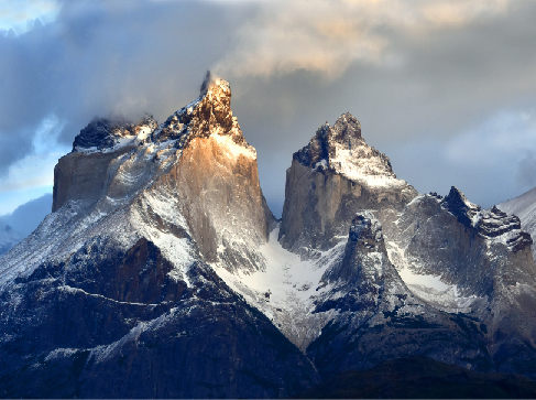
Once a mountain range is formed by upthrusting of the crust, its rocks are subject to erosion by water and ice. The sharp peaks and serrated edges have little to do with the forces that make the mountains initially. Instead, they result from the processes that tear down mountains. Ice is an especially effective sculptor of rock (Figure 8.11). In a world without moving ice or running water (such as the Moon or Mercury), mountains remain smooth and dull.
英語のヒント
地殻が押し上げられて山脈ができると、その岩石は水や氷による侵食を受ける。鋭い峰やギザギザの稜線は、初めに山を作った力とは、ほとんど関係がない。むしろ、山を削り取る過程から生じる。氷は、岩石を彫刻するのにとりわけ効果的である(図8.11)。月や水星のように、動く氷や流れる水のない世界では、山は滑らかで丸みのあるまま残る。
Mountains on Earth.地球の山々。
credit: David Morrison · CC BY 4.0
Figure 8.11 The Torres del Paine are a young region of Earth’s crust where sharp mountain peaks are being sculpted by glaciers. We owe the beauty of our young, steep mountains to the erosion by ice and water. (credit: David Morrison)
図8.11 トーレス・デル・パイネは地殻の若い領域で、氷河が鋭い山頂を削り出している。若く険しい山々の美しさは、氷と水による侵食のおかげである。(提供:David Morrison)