第6章植民地化と経済の拡大Colonization and Economic Expansion
6.2 The Rise of a Global Economy6.2 世界経済の台頭
Learning Objectives学習の目標
By the end of this section, you will be able to:
この節を学ぶと、次のことができるようになる。
Explain how the Seven Years’ War established a new balance of power in Europe
七年戦争がヨーロッパに新たな勢力均衡をどう成立させたかを説明する。
Discuss the causes and effects of Britain’s colonization of India
イギリスによるインド植民地化の原因と影響を論じる。
Analyze the ways in which the Qing dynasty developed and maintained a favorable balance of trade with Europe
清朝がヨーロッパに対して有利な貿易収支を築き、維持した方法を分析する。
Describe how colonized societies responded to the expansion of European empires
植民地化された社会が、ヨーロッパ諸帝国の拡大にどのように対応したかを述べる。
In the mid-1700s, the British Empire grew from a minor player on the world stage to a dominant superpower. Trade that flowed through and from the British North American colonies made many British business and political leaders rich. Victory in the Seven Years’ War consolidated their power over European rivals. In hopes of further increasing their political and economic power, many supported further expansion of the empire into new areas. Britain therefore expanded its colonies in India and turned its eyes to China.
英語のヒント
1700年代半ば、イギリス帝国は世界の舞台での小さな存在から、圧倒的な超大国へと成長した。イギリス領北アメリカ植民地を経由し、またそこから流れる貿易は、多くのイギリスの財界人と政治指導者を裕福にした。七年戦争での勝利は、ヨーロッパの競争相手に対する彼らの力を確固たるものにした。政治的・経済的な力をさらに増そうとして、多くの人々が新しい地域への帝国のさらなる拡大を支持した。そのためイギリスはインドの植民地を拡張し、中国へも目を向けた。
The Seven Years’ War七年戦争
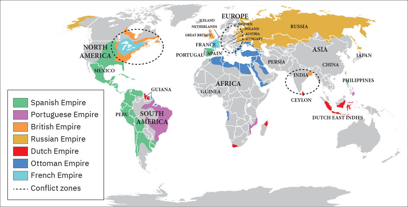
The Seven Years’ War (1756–1763) was a global conflict that began as a fight for dominance between European powers, primarily Great Britain and France, but it quickly involved groups from India, Africa, and the Americas (Figure 6.10). Conflicts that overlapped with the Seven Years’ War were the French and Indian War in North America and the Third Carnatic War in India.
英語のヒント
七年戦争(1756~1763年)は、主にイギリスとフランスというヨーロッパ列強の覇権争いとして始まった世界規模の戦争だった。しかし、まもなくインド、アフリカ、アメリカ大陸の諸集団も巻き込まれた(図6.10)。七年戦争と重なった紛争には、北アメリカのフレンチ・インディアン戦争と、インドの第3次カーナティック戦争がある。
The Seven Years’ War.七年戦争
(attribution: Copyright Rice University, OpenStax, under CC BY 4.0 license) · CC BY 4.0
Figure 6.10 This map shows a global view of the Seven Years’ War, which began in 1756. Note the many participants and the far-flung conflict zones. (attribution: Copyright Rice University, OpenStax, under CC BY 4.0 license)
英語のヒント
図6.10 この地図は、1756年に始まった七年戦争を世界規模で示している。参加した勢力の多さと、紛争地域の広がりに注目しよう。(帰属表示:著作権ライス大学、OpenStax。CC BY 4.0ライセンス)
In the late 1600s and early 1700s, New France grew steadily. In 1663, King Louis XIV canceled the royal charter with the Company of New France and transformed the settlement into a royal colony. French merchants and priests gradually expanded their reach from Quebec through the Great Lakes and down the Mississippi River, founding New Orleans near the Gulf of Mexico in 1718.
英語のヒント
1600年代後半から1700年代初頭にかけて、ヌーヴェル・フランスは着実に成長した。1663年、国王ルイ14世はヌーヴェル・フランス会社への王室特許状を取り消し、入植地を王領植民地へ変えた。フランスの商人や司祭は、ケベックから五大湖を通り、ミシシッピ川を下って、しだいに活動範囲を広げた。そして1718年、メキシコ湾近くにニューオーリンズを建設した。
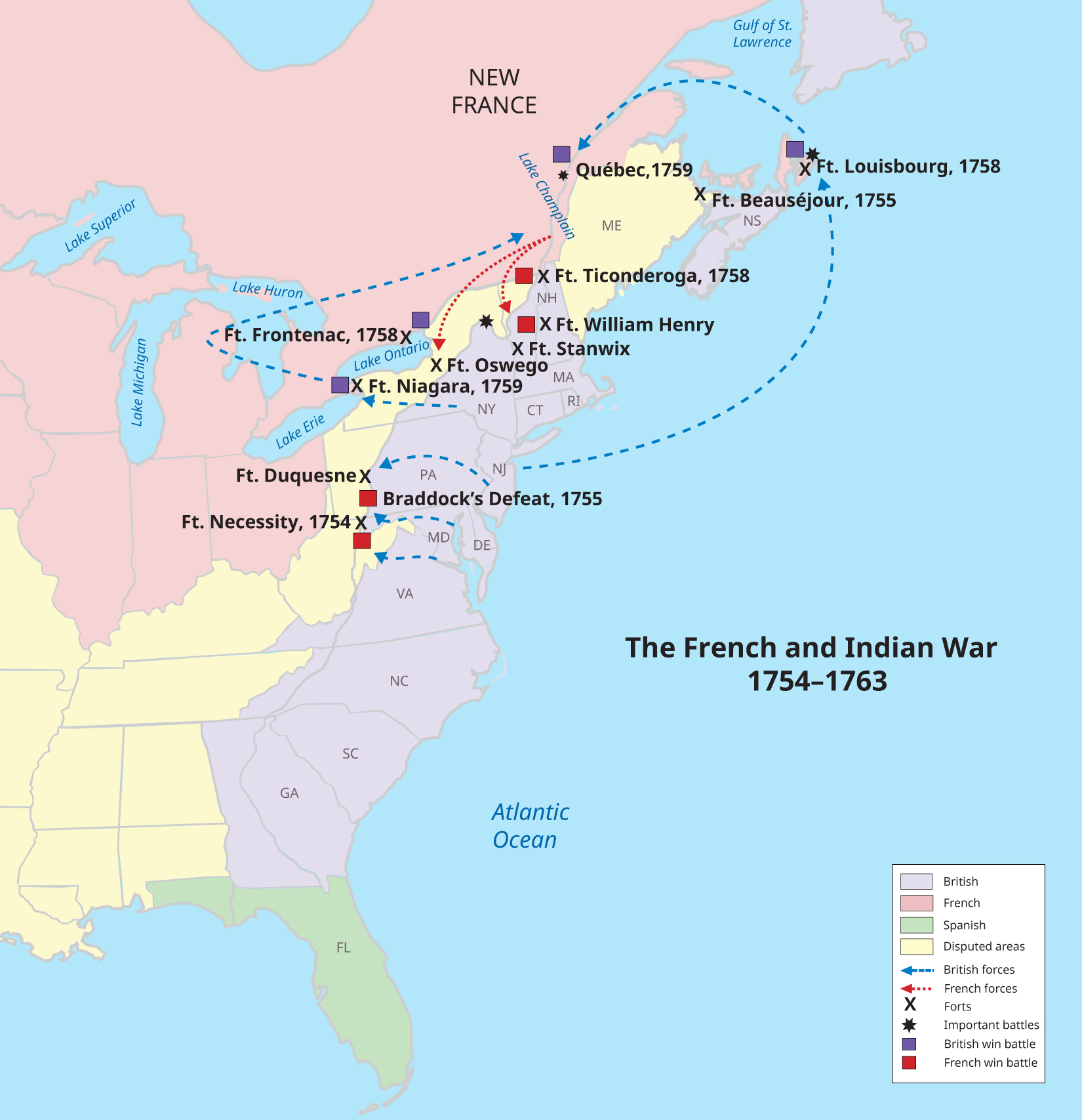
The English proved a serious obstacle for the growth of New France, however. Wealthy farmers in the English colonies of North America wanted to expand into the Ohio River Valley, territory claimed by France and its Native American allies. In 1754, violence broke out between French soldiers and members of the Virginia militia near what is now Uniontown, Pennsylvania. Initially the French and their Native American allies performed well, launching skillful ambushes on English troops and forcing George Washington, a young officer in the Virginia colonial militia, to surrender Britain’s Fort Necessity.
英語のヒント
しかし、イングランド人はヌーヴェル・フランスの成長にとって重大な障害となった。北アメリカのイングランド植民地の富裕な農園主は、フランスとその先住民同盟者が領有を主張するオハイオ川流域へ進出したがった。1754年、現在のペンシルヴェニア州ユニオンタウン付近で、フランス軍とヴァージニア民兵の間に武力衝突が起きた。当初は、フランス人と先住民の同盟勢力が優勢だった。イングランド軍に巧みな待ち伏せ攻撃を仕掛け、ヴァージニア植民地民兵の若い士官ジョージ・ワシントンに、イギリスのネセシティ砦を明け渡させた。
However, the early success of the French in forcing the British to retreat did not last. In 1758, the Shawnee tribe, the Delaware tribe, and the powerful Iroquoian Confederacy agreed to ally with the English in exchange for their promise to respect Indigenous rights to contested lands on the frontier. The Iroquois Confederacy was a collection of allied Native American tribes who called themselves Haudenosaunee, which means “people of the longhouse.” The name referred both to the rectangular homes in which they lived and their geographic territory, which extended from what is now Vermont in the east all the way to Lake Erie in the west, an area roughly the shape of a longhouse. The Iroquoian tribes had formed a military and economic alliance by 1600 that consisted of the Mohawk, Oneida, Onondaga, Cayuga, and Seneca tribes. The Tuscarora tribe joined the confederacy in 1722. Other, non-Iroquoian Native Americans, including several Algonquin tribes, remained loyal to the French until the end of the war in 1763. With Native American help, the English launched successful offensives against New France. The British turned in the tide in 1759, with a series of victories culminating in their capture of French Quebec after the Battle on the Plains of Abraham (Figure 6.11).
英語のヒント
しかし、イギリス軍を退却させたフランス軍の初期の成功は続かなかった。1758年、ショーニー族、デラウェア族、そして強力なイロコイ連邦は、境界地帯の係争地に対する先住民の権利を尊重するという約束と引き換えに、イングランド人との同盟に同意した。イロコイ連邦は、同盟した先住民諸部族の集まりで、彼ら自身は「長い家の人々」を意味するホデノショーニと名乗っていた。この名は、彼らが住んだ長方形の家屋と、東の現在のヴァーモントから西のエリー湖まで延びる領域の両方を指していた。その領域の形は、おおよそ長い家に似ていた。イロコイ語系の諸部族は1600年までに軍事・経済同盟を形成しており、構成員はモホーク、オナイダ、オノンダガ、カユーガ、セネカの各部族だった。1722年にはタスカローラ族が連邦に加わった。アルゴンキン語系のいくつかの部族を含む、イロコイ語系以外の先住民は、1763年の終戦までフランスへの忠誠を保った。先住民の助力を得たイングランド軍は、ヌーヴェル・フランスへの攻撃を成功させた。1759年、イギリス軍は一連の勝利によって形勢を逆転し、その頂点となったのが、アブラハム平原の戦いの後のフランス領ケベック占領だった(図6.11)。
Key Battles.主要な戦闘
(attribution: Copyright Rice University, OpenStax, under CC BY 4.0 license) · CC BY 4.0
Figure 6.11 This map shows the key battles of the French and Indian War (1754–1763), including Britain’s loss at Fort Duquesne where George Washington fought and its decisive victory in Quebec. (attribution: Copyright Rice University, OpenStax, under CC BY 4.0 license)
図6.11 この地図は、フレンチ・インディアン戦争(1754~1763年)の主要な戦闘を示す。ジョージ・ワシントンが戦ったデュケーヌ砦でのイギリス軍の敗北や、ケベックでの決定的勝利が含まれる。(帰属表示:著作権ライス大学、OpenStax。CC BY 4.0ライセンス)
The French and Indian War ended with the victory of Great Britain and Prussia over France and Spain in the Seven Years’ War and the signing of the Treaty of Paris in February 1763. Under the treaty, the French government surrendered all its territory in North America, as well as outposts in the Caribbean, India, and Africa. Britain became the undisputed controller of eastern North America, from Canada in the north to the Florida border in the south, and from the Atlantic Ocean in the east to the Mississippi River in the west.
英語のヒント
フレンチ・インディアン戦争は、七年戦争でのイギリス・プロイセンのフランス・スペインに対する勝利と、1763年2月のパリ条約調印によって終わった。条約により、フランス政府は北アメリカの全領土に加え、カリブ海、インド、アフリカの拠点を譲り渡した。イギリスは、北のカナダから南のフロリダとの境界まで、東の大西洋から西のミシシッピ川まで、北アメリカ東部を誰にも争われずに支配する国となった。
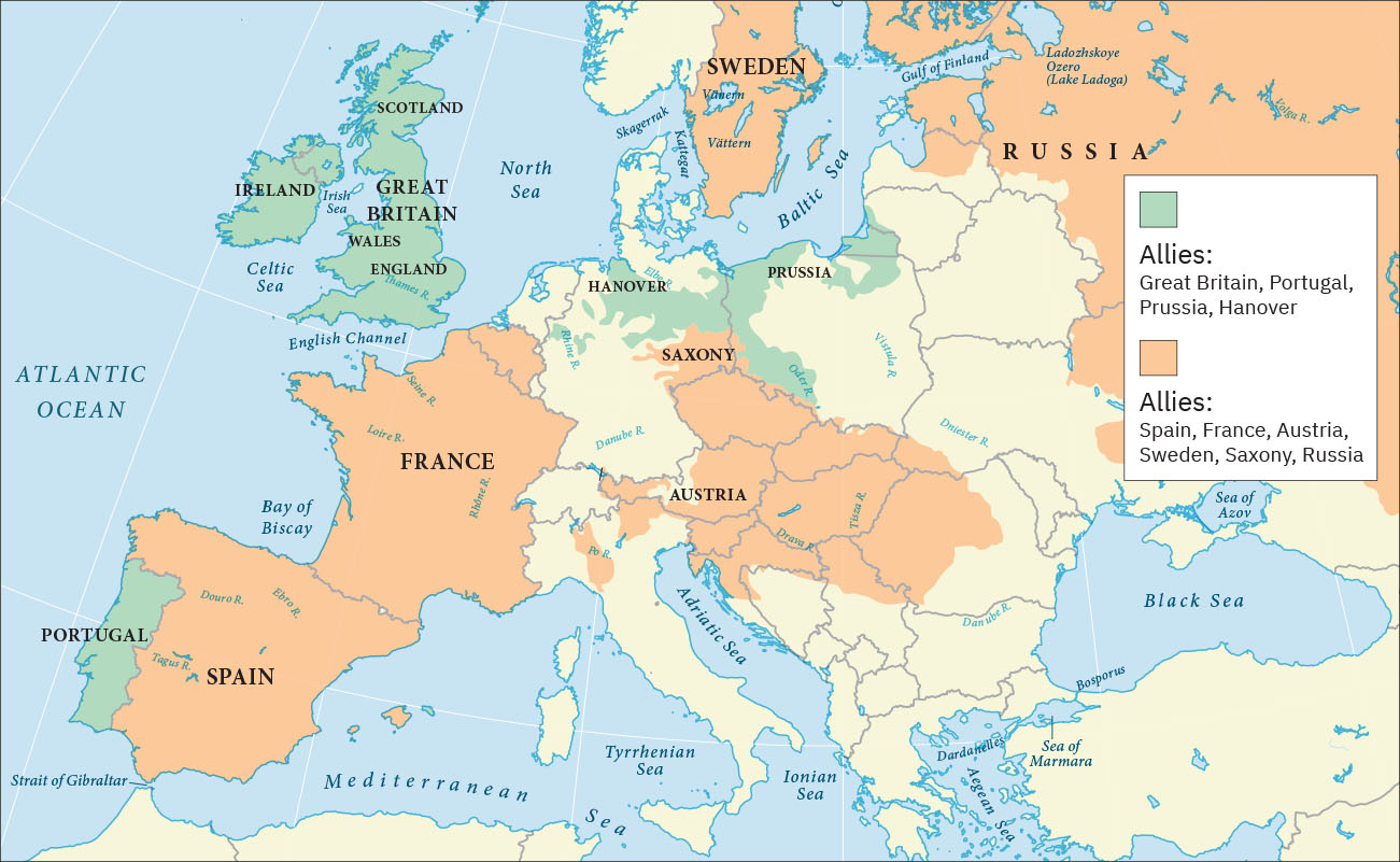
The Seven Years’ War had begun in Europe in 1756 when Frederick the Great of Prussia invaded Saxony and annexed the area as part of his broader plan to expand Prussian territory. In response, France, Spain, and Russia joined forces with Austria to oppose him. Great Britain allied itself with Prussia to maintain the balance of power in Europe, a situation in which competing nations have approximately equal military power. Maintaining this balance was a key feature of British foreign policy meant to prevent the domination of Europe by any one nation. Military alliances thus transformed what could have been a small border dispute in Europe into a major war that quickly spread around the world (Figure 6.12).
英語のヒント
ヨーロッパで七年戦争が始まったのは1756年で、プロイセンのフリードリヒ大王が領土拡張の大きな計画の一環としてザクセンへ侵攻し、併合したことがきっかけだった。これに対し、フランス、スペイン、ロシアがオーストリアと力を合わせ、彼に対抗した。イギリスはヨーロッパの勢力均衡を保つため、プロイセンと同盟した。勢力均衡とは、競合する国々がおおよそ同じ軍事力を持つ状態である。この均衡の維持は、どこか1国がヨーロッパを支配することを防ぐ、イギリス外交の重要な特徴だった。このように軍事同盟は、ヨーロッパの小さな国境紛争で終わったかもしれない争いを、まもなく世界中へ広がる大戦争へ変えた(図6.12)。
Allies in Europe.ヨーロッパの同盟国
(attribution: Copyright Rice University, OpenStax, under CC BY 4.0 license) · CC BY 4.0
In 1758, a British expeditionary force captured the French outpost of Senegal in West Africa, and other French outposts were taken during a series of subsequent offensives. The loss of valuable trading ports damaged the French economy at the very moment France desperately needed money to fund the war effort. More importantly, it deprived French military forces of strategic bases they could have used to raid British shipping and resupply their warships.
英語のヒント
1758年、イギリスの遠征軍は西アフリカのフランス拠点セネガルを攻略し、その後の一連の攻勢で、ほかのフランス拠点も奪った。価値のある貿易港の喪失は、戦争を遂行する資金をフランスが切実に必要としていたまさにそのときに、フランス経済へ損害を与えた。さらに重要なことに、フランス軍は、イギリス船を襲撃したり自国の軍艦に補給したりするのに使えたはずの、戦略的な基地を失った。
In Asia, the British East India Company, a joint stock company founded in 1600 with the original goal of trading in the Indian Ocean, was by now providing the British with a much stronger economic as well as military and diplomatic foundation than their French rivals had. To thwart these British advantages and gain control of valuable territory in India, the French formed an alliance with the Mughal Empire. At its height, this powerful Muslim realm had once ruled more than 150 million people living across 1.5 million square miles in what is now Afghanistan, India, and Bangladesh. The British defeated the French forces in 1761, however, when they captured Pondicherry, the most important French outpost in India. The Mughals continued to resist British domination even after the French had largely withdrawn from India.
英語のヒント
アジアでは、1600年に当初はインド洋交易を目的として設立された株式会社、イギリス東インド会社が、このころには、フランス側をはるかに上回る経済的・軍事的・外交的基盤をイギリスに与えていた。イギリスのこうした優位をくじき、インドの価値ある領土を支配しようと、フランスはムガル帝国と同盟した。この強大なイスラーム王国は最盛期には、現在のアフガニスタン、インド、バングラデシュに広がる150万平方マイルの領域で、1億5,000万人を超える人々を支配していた。しかし1761年、イギリス軍はインドで最も重要なフランス拠点ポンディシェリを占領し、フランス軍を破った。フランスがインドからおおむね撤退した後も、ムガル帝国はイギリスの支配に抵抗し続けた。
In 1762, the British launched attacks on Spanish colonies in Asia and the Caribbean, capturing the port of Manila in the Philippines and occupying it until the end of the war in 1763. They were less successful in expanding their control over the islands, despite the assistance of Indigenous Filipinos who disliked Spanish rule. In the Caribbean, however, Britain succeeded in capturing Havana, Cuba, one of the most important ports in the Western Hemisphere, and held it until the end of the conflict.
英語のヒント
1762年、イギリスはアジアとカリブ海のスペイン植民地を攻撃し、フィリピンのマニラ港を攻略して、1763年の終戦まで占領した。スペイン支配を嫌うフィリピン先住民の支援があったにもかかわらず、島々への支配拡大はあまり成功しなかった。しかしカリブ海では、西半球で最も重要な港の一つ、キューバのハバナの攻略に成功し、戦争が終わるまで保持した。
Furthermore, with the signing of the Treaty of Paris, the French surrendered their imperial possessions in North America and India to the British, while the Spanish surrendered Florida to the British and France gave control of the Louisiana Territory to Spain. The subsequent Peace of Hubertusburg guaranteed Prussian control of Silesia, an area in central Europe, and confirmed Prussia’s status as a major force in Europe. The British, for their part, emerged from the Seven Years’ War as the world’s leading economic, military, and political power.
英語のヒント
さらにパリ条約の調印により、フランスは北アメリカとインドにあった帝国の領有地をイギリスへ譲渡した。スペインはフロリダをイギリスへ譲り、フランスはルイジアナ領の支配をスペインへ引き渡した。続くフベルトゥスブルクの和約は、中央ヨーロッパの一地域であるシュレジエンに対するプロイセンの支配を保障し、ヨーロッパの大国としてのプロイセンの地位を確認した。イギリスは七年戦争を経て、経済・軍事・政治の各面で世界をリードする大国となった。