第10章信仰と帝国Empires of Faith
Introductionはじめに
Sasanians in Victory.勝利するサーサーン朝
(credit: modification of work “Naqsh i Rustam. Shapour” by Unknown/Wikimedia Commons, CC BY 2.5) · CC BY 2.5
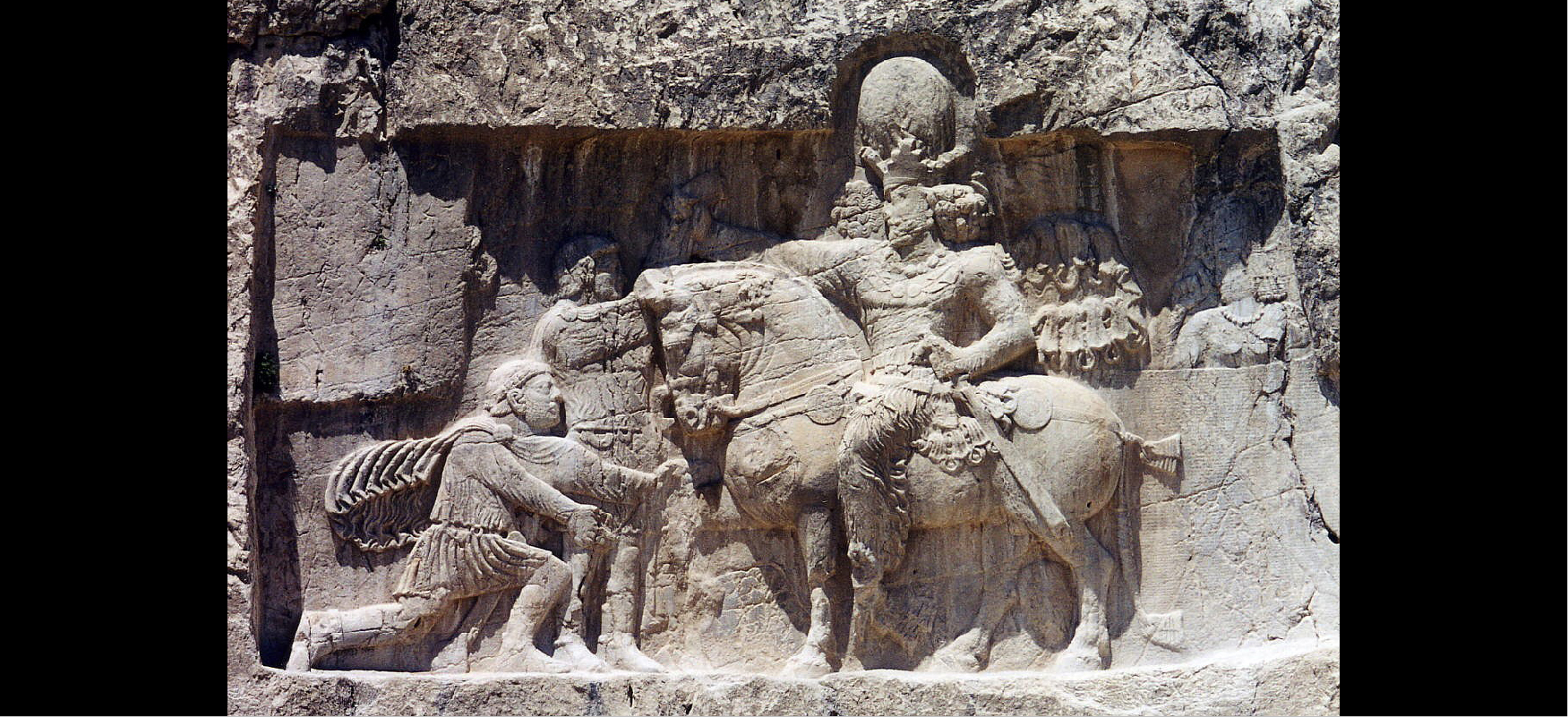
Figure 10.1 This rock relief at Naqsh-e Rostam in modern Iran commemorates Shapur I’s victories over Rome. The kneeling emperor is identified as Philip the Arab, seeking peace; the standing emperor whose hand Shapur holds is Valerian, captured near Edessa in 260 CE. (credit: modification of work “Naqsh i Rustam. Shapour” by Unknown/Wikimedia Commons, CC BY 2.5)
図10.1 現在のイランにあるナクシェ・ロスタムのこの岩壁浮彫は、シャープール1世のローマに対する勝利を記念する。ひざまずく皇帝は、和平を求めるフィリップス・アラブス、立ってシャープールに手をつかまれている皇帝は、紀元後260年にエデッサ付近で捕らえられたウァレリアヌスと同定される。(クレジット:「Naqsh i Rustam. Shapour」、作者不明/Wikimedia Commonsを改変、CC BY 2.5)
The later Roman Empire was a time of profound cultural, political, and religious transformations. Various crises in the Roman government, as well as the rise of Christianity, propelled these changes. In the third century CE, the emperor Valerian’s capture by the Sasanians was an indication of how easily the Roman Empire’s prominence could fluctuate and fissure (Figure 10.1). Stretching from the island of Britannia (Britain) in the Roman West to Syria in the Roman East, the empire continually struggled in its relationships with foreign groups on its eastern and western frontiers. The threatening presence of the Sasanians and other marginal states in the Mediterranean, including various Germanic kingdoms in the west and Palmyra in the east, reflected a new state of affairs.
英語のヒント
ローマ帝国後期は、文化・政治・宗教が深く変わった時代だった。ローマ政府のさまざまな危機に加え、キリスト教の台頭も、その変化を進めた。紀元後3世紀に皇帝ウァレリアヌスがサーサーン朝の捕虜となった出来事は、ローマ帝国の優位が、いかに容易に揺らぎ、亀裂を生じ得るかを示していた(図10.1)。西のブリタンニア島、現在のブリテン島から、東のシリアまで広がる帝国は、東西の国境で外部集団との関係に絶えず苦しんだ。サーサーン朝に加え、西のゲルマン諸王国や東のパルミラなど、地中海周辺の国家が脅威として存在することは、新たな情勢を映していた。
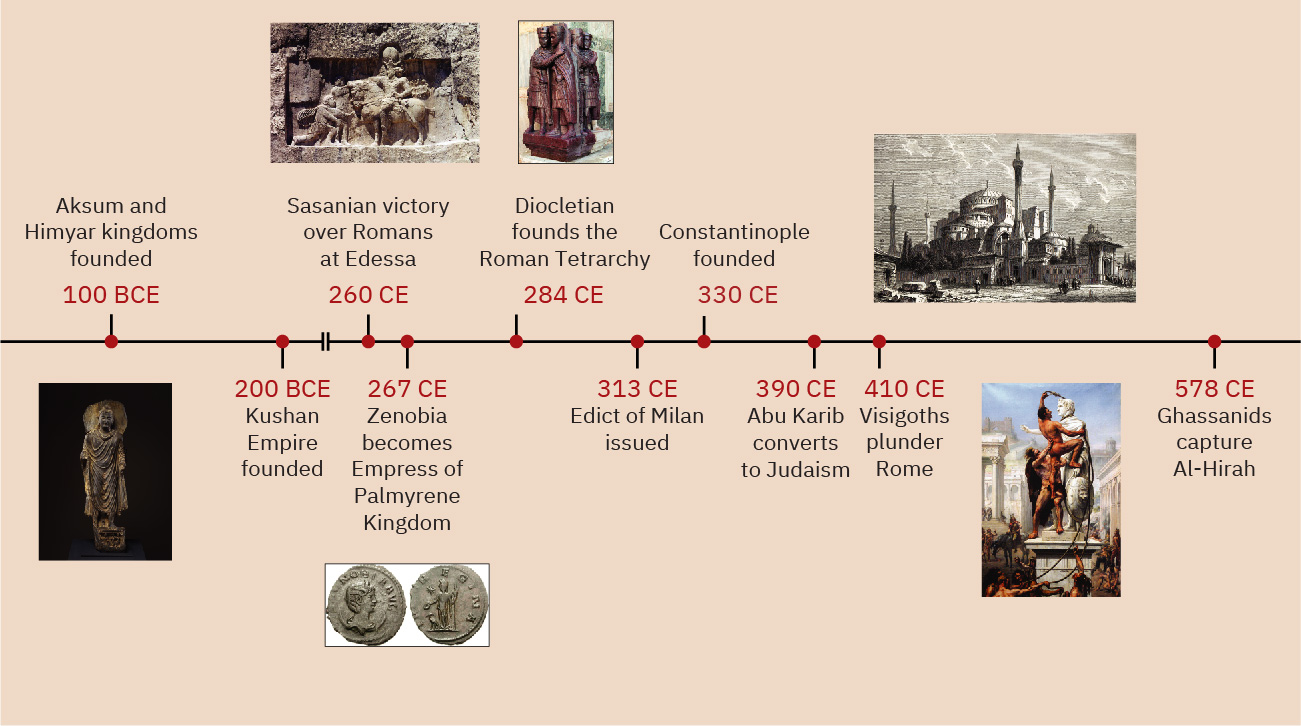
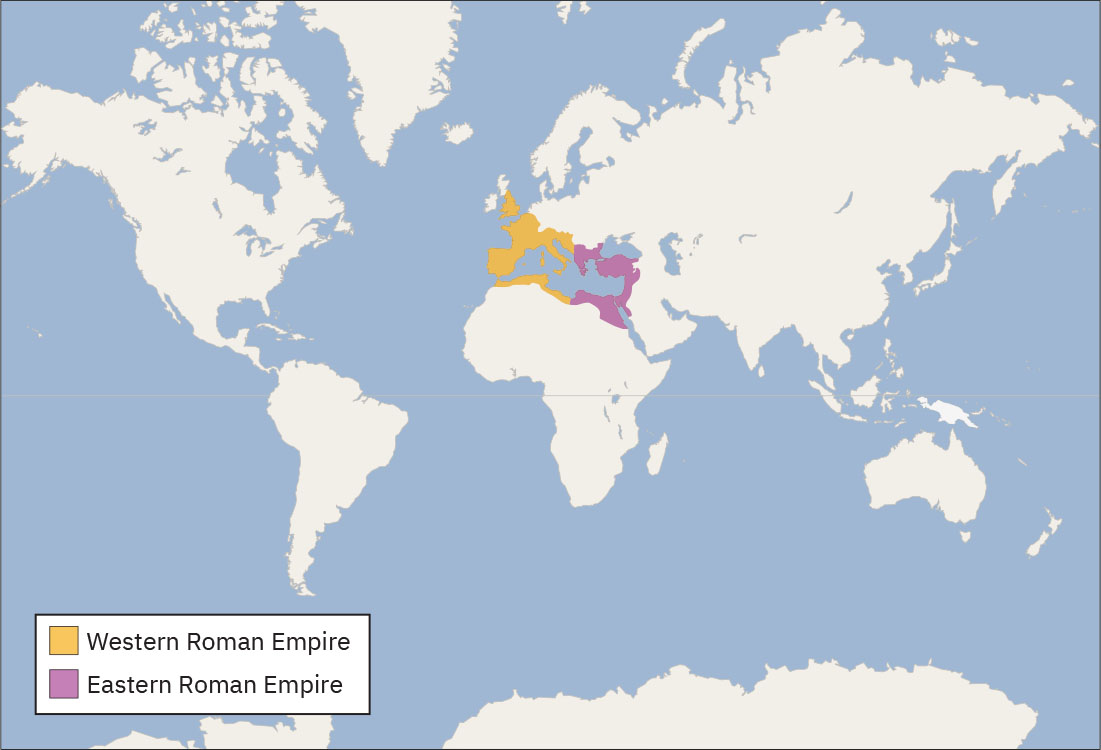
The empire shifted its focus eastward, a trend signaled most prominently by its reorientation around its new capital in Constantinople (today’s Istanbul). The Romans then saw their power and sphere of influence shift as well. With a growing Christian population and shrinking borders, the entity that now became the Byzantine Empire persisted in the eastern Mediterranean. Yet it had to grapple with the migration of different groups through its territory as well as the disintegration of the western empire into small independent states. In addition, smaller states such as Aksum in sub-Saharan Africa and the Kushan Empire in central Asia came onto the scene during this period, establishing their own thriving societies away from the Mediterranean while being interconnected as neighbors and trade partners. The interrelationships among this multitude of states reflect the complicated circumstances of the Late Antique world.
英語のヒント
帝国の重心は東へ移った。その動きを最もよく示すのが、コンスタンティノープル、現在のイスタンブルを新しい首都として、帝国が再編されたことだった。ローマ人の権力と勢力圏も、それに伴って変わった。キリスト教徒の人口が増え、領域が縮小する中、ビザンツ帝国と呼ばれるようになる国家は、東地中海で存続した。しかし、領内を移動するさまざまな集団への対応や、西帝国が小さな独立国家へ分裂していく事態に向き合う必要があった。この時代には、サハラ以南のアフリカのアクスムや、中央アジアのクシャーナ朝など、より小規模な国家も登場した。それらは地中海から離れた場所で独自の繁栄する社会を築きながら、隣国や交易相手として互いにつながっていた。こうした多数の国家の相互関係は、古代末期の世界の複雑な状況を表している。
Timeline: Empires of Faith.年表:信仰と帝国
(credit “200 BCE”: modification of work “Buddha” by Purchase, Denise and Andrew Saul Gift, in honor of Maxwell K. Hearn, 2014/The Metropolitan Museum of Art, Public Domain; credit “260 CE”: modification of work “Naqsh i Rustam. Shapour” by Unknown/Wikimedia Commons, CC BY 2.5; credit “267 CE”: modification of work “Zenobia” by Classical Numismatic Group Wikimedia Commons, Public Domain; credit “284 CE”: modification of work “Portrait of the Four Tetrarchs” by Jean-Pol Grandmont/Wikimedia Commons, CC BY 4.0; credit “330 CE”: modification of work “Lithography of the Hagia Sophia, Istanbul, 1857” by Dmitry Makeev/Wikimedia Commons, Public Domain; credit “410 CE”: modification of work “The Sack of Rome in 410 by the Barbarians” by Das Königreich der Vandalen/Wikimedia Commons, Public Domain) · CC BY-SA 4.0 (composite); constituent credits retained
Figure 10.2 (credit “200 BCE”: modification of work “Buddha” by Purchase, Denise and Andrew Saul Gift, in honor of Maxwell K. Hearn, 2014/The Metropolitan Museum of Art, Public Domain; credit “260 CE”: modification of work “Naqsh i Rustam. Shapour” by Unknown/Wikimedia Commons, CC BY 2.5; credit “267 CE”: modification of work “Zenobia” by Classical Numismatic Group, Inc./Wikimedia Commons, CC BY-SA 2.5; credit “284 CE”: modification of work “Portrait of the Four Tetrarchs” by Jean-Pol Grandmont/Wikimedia Commons, CC BY 4.0; credit “330 CE”: modification of work “Lithography of the Hagia Sophia, Istanbul, 1857” by Dmitry Makeev/Wikimedia Commons, Public Domain; credit “410 CE”: modification of work “The Sack of Rome in 410 by the Barbarians” by Das Königreich der Vandalen/Wikimedia Commons, Public Domain)
図10.2 (「前200年」のクレジット:「Buddha」、Purchase, Denise and Andrew Saul Gift, in honor of Maxwell K. Hearn, 2014/The Metropolitan Museum of Artを改変、パブリックドメイン。「260年」:「Naqsh i Rustam. Shapour」、作者不明/Wikimedia Commonsを改変、CC BY 2.5。「267年」:「Zenobia」、Classical Numismatic Group, Inc./Wikimedia Commonsを改変、CC BY-SA 2.5。「284年」:「Portrait of the Four Tetrarchs」、Jean-Pol Grandmont/Wikimedia Commonsを改変、CC BY 4.0。「330年」:「Lithography of the Hagia Sophia, Istanbul, 1857」、Dmitry Makeev/Wikimedia Commonsを改変、パブリックドメイン。「410年」:「The Sack of Rome in 410 by the Barbarians」、Das Königreich der Vandalen/Wikimedia Commonsを改変、パブリックドメイン。)
Locator Map: Empires of Faith.位置図:信仰と帝国
(credit: modification of work “World map blank shorelines” by Maciej Jaros/Wikimedia Commons, Public Domain) · Public Domain
Figure 10.3 (credit: modification of work “World map blank shorelines” by Maciej Jaros/Wikimedia Commons, Public Domain)
図10.3 (クレジット:「World map blank shorelines」、Maciej Jaros/Wikimedia Commonsを改変、パブリックドメイン)