第9章古代のアフリカAfrica in Ancient Times
Introductionはじめに
San Men among Elephants.ゾウの群れの中にいるサンの男性たち。
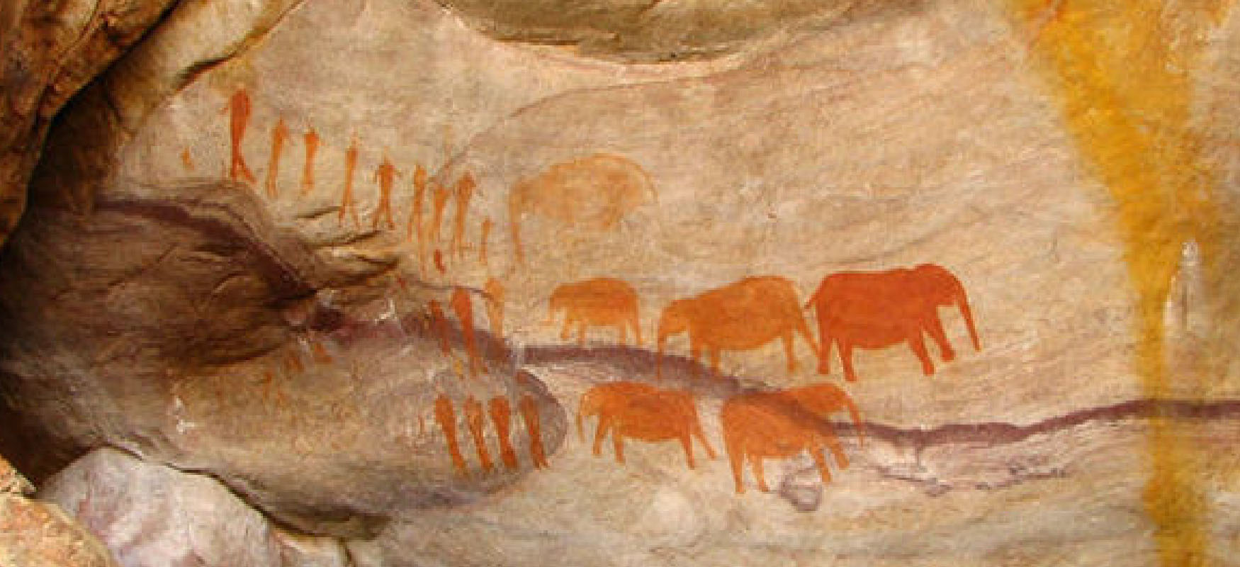
(credit: modification of work “Cave painting created by the San people in the Cederberg Cave near Stadsaal” by “Valroe”/Wikimedia Commons, Public Domain) · Public Domain
Figure 9.1 This rock art in the Cederberg Caves, South Africa, depicts a group of twenty San men interacting with a group of six elephants. In the center of the image, a small elephant extends its trunk as if to sniff one of the men. Painted around 5500 BCE, the artwork likely depicts the special bond between the San people and the elephants, and it demonstrates that even thousands of years ago these African peoples had developed a keen understanding of elephant behavior and characteristics. (credit: modification of work “Cave painting created by the San people in the Cederberg Cave near Stadsaal” by “Valroe”/Wikimedia Commons, Public Domain)
図9.1 南アフリカのセダーバーグ洞窟にあるこの岩絵は、サンの男性20人ほどが6頭のゾウと関わる様子を描いている。中央では、小さなゾウが男性の一人のにおいをかぐかのように鼻を伸ばしている。前5500年ごろに描かれたこの作品は、おそらくサンの人々とゾウの特別な結びつきを表す。数千年前にすでに、これらのアフリカの人々がゾウの行動や特徴を鋭く理解していたことも示している。(出典:「Valroe」「Cave painting created by the San people in the Cederberg Cave near Stadsaal」を改変、Wikimedia Commons、パブリックドメイン)
More than eleven million square miles in size, Africa is Earth’s second-largest continent and home to a huge diversity of geographies and climates. Its environments range from arid desertscapes with sand dunes hundreds of feet high to lush tropical rainforests blanketed by impenetrably dense foliage. Its peoples have adapted to these environments over millennia (Figure 9.1), and their achievements were great, but extreme climates wreak havoc on the historical record. Ancient Africa was nevertheless a marvelous mosaic of unique civilizations, and the more historians work at uncovering their pasts, the clearer our picture will be of their accomplishments and contributions to world history.
英語のヒント
面積が1,100万平方マイルを超えるアフリカは、地球で2番目に大きい大陸であり、きわめて多様な地形と気候を持つ。数百フィートもの砂丘がそびえる乾燥した砂漠から、入り込めないほど密生した葉に覆われた、緑豊かな熱帯雨林まで、さまざまな環境が広がっている。人々は数千年にわたり、こうした環境に適応してきた(図9.1)。大きな成果をあげてきたものの、厳しい気候は歴史の記録に甚大な損傷を与える。それでも、古代アフリカは独自の文明が織りなす見事なモザイクだった。歴史家がそれぞれの過去を解き明かす作業を進めるほど、それらの文明の業績や世界史への貢献が、いっそう明らかになる。
Timeline: Africa in Ancient Times.年表:古代のアフリカ。
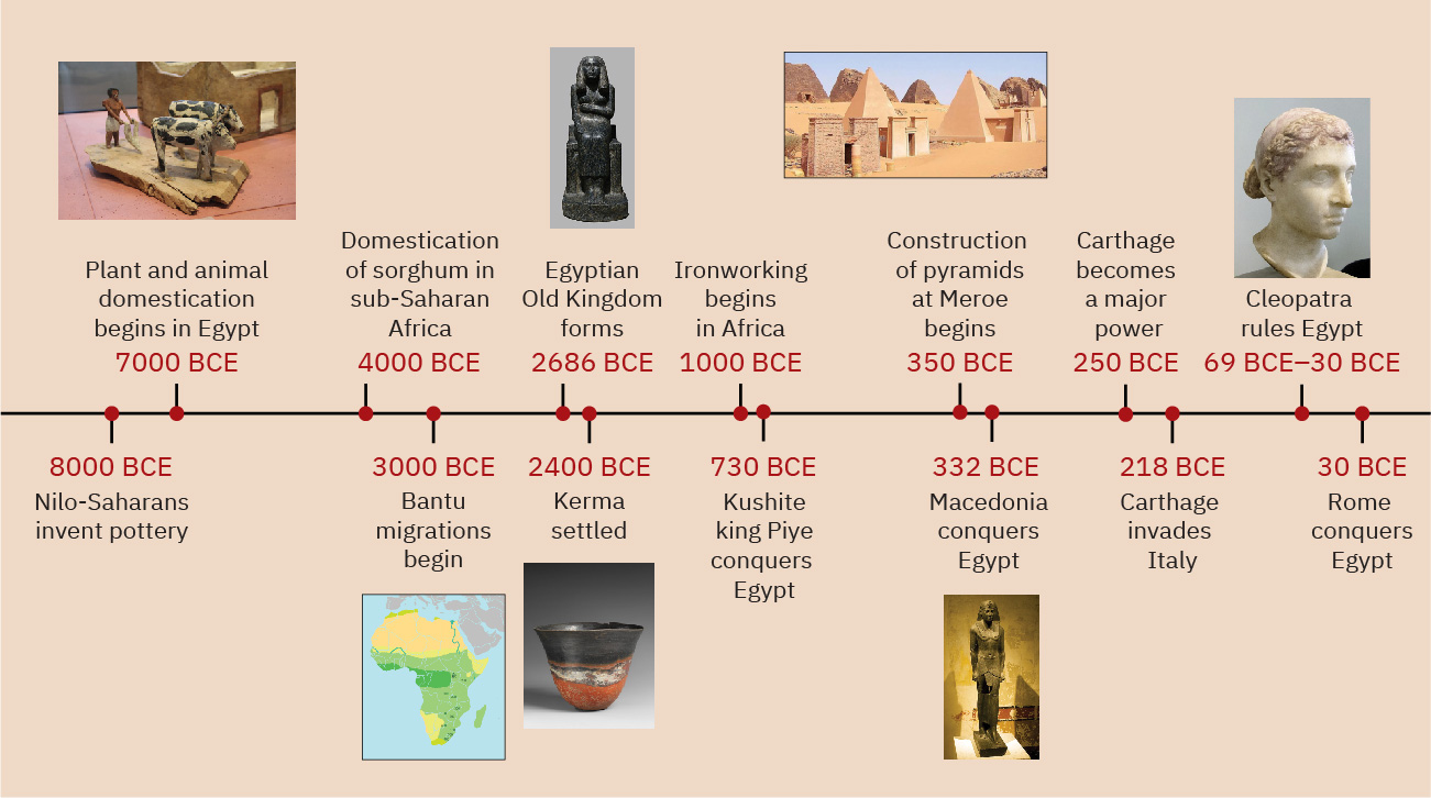
(credit “7000 BCE”: modification of work “Ancient Egypt Wooden Farmer & Oxen Model, Middle Kingdom, c. 2000 BC” by Gary Todd/Flickr, CC0 1.0; credit “3000 BCE”: modification of work “‘Spread of the "Early Iron Age’ in Eastern, Central and Southern Africa, a proxy for the Bantu migrations” by Kevin Shillington/Wikimedia Commons, Public Domain; credit “2686 BCE”: modification of work “Statue of princess Redji” by Museo Egizio/Wikimedia Commons, CC0 1.0; credit “2400 BCE”: modification of work “Classic Kerma Beaker” by Rogers Fund, 1920/The Metropolitan Museum of Art, Public Domain; credit “350 BCE”: modification of work “Pyramids N26 and N27” by “Wufei07”/Wikimedia Commons, Public Domain; credit “332 BCE”: modification of work “Ptolemy III Euergetes” by Szilas/Wikimedia Commons, Public Domain; credit “69 BCE–30 BCE”: modification of work “Marble bust of Cleopatra VII of Egypt” by Altes Museum Berlin/Louis le Grand/Wikimedia Commons, Public Domain) · CC0 1.0 + Public Domain
Figure 9.2 (credit “7000 BCE”: modification of work “Ancient Egypt Wooden Farmer & Oxen Model, Middle Kingdom, c. 2000 BC” by Gary Todd/Flickr, CC0 1.0; credit “3000 BCE”: modification of work “‘Spread of the "Early Iron Age’ in Eastern, Central and Southern Africa, a proxy for the Bantu migrations” by Kevin Shillington/Wikimedia Commons, Public Domain; credit “2686 BCE”: modification of work “Statue of princess Redji” by Museo Egizio/Wikimedia Commons, CC0 1.0; credit “2400 BCE”: modification of work “Classic Kerma Beaker” by Rogers Fund, 1920/The Metropolitan Museum of Art, Public Domain; credit “350 BCE”: modification of work “Pyramids N26 and N27” by “Wufei07”/Wikimedia Commons, Public Domain; credit “332 BCE”: modification of work “Ptolemy III Euergetes” by Szilas/Wikimedia Commons, Public Domain; credit “69 BCE–30 BCE”: modification of work “Marble bust of Cleopatra VII of Egypt” by Altes Museum Berlin/Louis le Grand/Wikimedia Commons, Public Domain)
図9.2 (「前7000年」の出典:Gary Todd「Ancient Egypt Wooden Farmer & Oxen Model, Middle Kingdom, c. 2000 BC」を改変、Flickr、CC0 1.0。「前3000年」の出典:Kevin Shillington「Spread of the Early Iron Age in Eastern, Central and Southern Africa, a proxy for the Bantu migrations」を改変、Wikimedia Commons、パブリックドメイン。「前2686年」の出典:Museo Egizio「Statue of princess Redji」を改変、Wikimedia Commons、CC0 1.0。「前2400年」の出典:Rogers Fund, 1920「Classic Kerma Beaker」を改変、メトロポリタン美術館、パブリックドメイン。「前350年」の出典:「Wufei07」「Pyramids N26 and N27」を改変、Wikimedia Commons、パブリックドメイン。「前332年」の出典:Szilas「Ptolemy III Euergetes」を改変、Wikimedia Commons、パブリックドメイン。「前69〜前30年」の出典:Altes Museum Berlin/Louis le Grand「Marble bust of Cleopatra VII of Egypt」を改変、Wikimedia Commons、パブリックドメイン)
Locator Map: Africa in Ancient Times.位置図:古代のアフリカ。
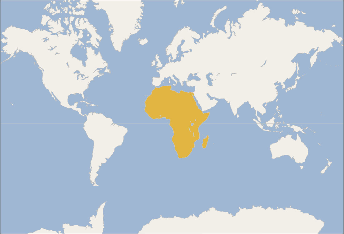
(credit: modification of work “World map blank shorelines” by Maciej Jaros/Wikimedia Commons, Public Domain) · Public Domain
Figure 9.3 (credit: modification of work “World map blank shorelines” by Maciej Jaros/Wikimedia Commons, Public Domain)
図9.3 (出典:Maciej Jaros「World map blank shorelines」を改変、Wikimedia Commons、パブリックドメイン)