第9章古代のアフリカAfrica in Ancient Times
9.4 North Africa’s Mediterranean and Trans-Saharan Connections9.4 北アフリカと地中海世界・サハラ縦断路のつながり
Learning Objectives学習の目標
By the end of this section, you will be able to:
この節を読み終えると、次のことができるようになる。
Describe the interactions between North Africa, the Levant, and Europe
北アフリカ、レヴァント、ヨーロッパの相互交流を説明する。
Analyze the trade routes from North Africa to the Mediterranean, the Sahara, and the Levant
北アフリカから地中海、サハラ、レヴァントへ伸びる交易路を分析する。
The Mediterranean coast of North Africa has been a crossroads of civilizations for millennia. Beginning in the first millennium BCE, it was occupied successively by a string of invaders, including the Phoenicians, Greeks, Romans, Vandals, and Arabs, and it has been the site of countless internal migrations, as in the case of the Mauri and Massylii peoples. One result of these interactions was a long-term process of cultural commingling, reabsorption, and acculturation that has left a rich tapestry of human societies in its wake.
英語のヒント
北アフリカの地中海沿岸は、数千年にわたって文明の交差点となってきた。前1千年紀以降、フェニキア人、ギリシア人、ローマ人、ヴァンダル人、アラブ人など、相次ぐ侵入者が次々にこの地を占領した。また、マウリ人やマッシュリイ人のように、域内を移動する人々も数え切れないほどいた。こうした相互交流から、長い時間をかけた文化の混交、再吸収、文化変容が生じた。その積み重ねが、多様な人間社会の織りなす豊かな世界を残した。
North Africa and Egypt北アフリカとエジプト
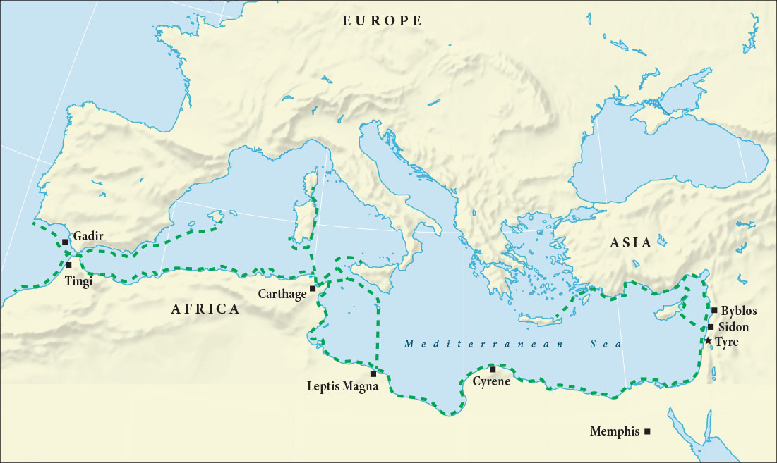
The Phoenicians were responsible for the earliest known trade network that unified the Mediterranean world. A Semitic-speaking and seafaring people originally from the Levant, or eastern Mediterranean coast, the Phoenicians emerged initially from the areas around Tyre in what is present-day Lebanon (or Canaan in the Bible, which refers to the Phoenicians as the Canaanites). Around the end of the tenth century BCE, the Phoenicians began to found a series of trading posts and colonies along the Mediterranean coast, a loop of interconnected settlements that eventually stretched from Byblos in the east to Nimes and Gadir (Cadiz) in the west and Libdah (Leptis Magna) in the south (Figure 9.19). In 814 BCE, they established what would become their greatest settlement, Carthage. Located on the North African coast in modern-day Tunisia, Carthage was in an ideal position to dominate the trade activities of the western Mediterranean.
英語のヒント
地中海世界を一つにつなぐ、知られている最も初期の交易網を築いたのはフェニキア人だった。彼らは、もともとレヴァント、すなわち地中海東岸に住み、セム系の言語を話す航海民である。その起源は、現在のレバノンにあるティルス周辺にあった。この地域は聖書のカナンに当たり、聖書ではフェニキア人をカナン人と呼ぶ。前10世紀の終わりごろ、フェニキア人は地中海沿岸に交易拠点や植民市を次々と築き始めた。それらは互いにつながる環状の居住地網となり、やがて東のビュブロスから、西のニームやガディル(カディス)、南のリブダ(レプティス・マグナ)まで伸びた(図9.19)。前814年、彼らは後に最大の拠点となるカルタゴを建設した。現在のチュニジアに当たる北アフリカ沿岸に位置するカルタゴは、西地中海の交易活動を支配するのに理想的な場所にあった。
Phoenician Settlements and Trade Routes.フェニキア人の居住地と交易路
(attribution: Copyright Rice University, OpenStax, under CC BY 4.0 license) · CC BY 4.0
Figure 9.19 Beginning in the tenth century BCE, the Phoenicians established colonies and trading outposts along the Mediterranean coasts of North Africa and southern Europe. Areas that experienced either Phoenician contact or settlement are those identified with the green dotted line. Carthage, the most impressive Phoenician settlement, juts out into the western Mediterranean from the North African coast, making it an ideal place to manage and control trade in the sea. (attribution: Copyright Rice University, OpenStax, under CC BY 4.0 license)
図9.19 前10世紀以降、フェニキア人は北アフリカと南ヨーロッパの地中海沿岸に植民市や交易拠点を築いた。緑の点線で示すのは、フェニキア人と接触した、または彼らが定住した地域である。最大の拠点カルタゴは、北アフリカ沿岸から西地中海へ突き出す位置にあり、海上交易を管理・支配するのに理想的だった。(出典:著作権 Rice University, OpenStax、CC BY 4.0)
The government of Carthage was originally a monarchy, but by the turn of the fourth century BCE, it had given way to a republic. The Carthaginian republic was singled out for praise by the Greek philosopher Aristotle, who considered it the perfect balance between monarchy, aristocracy, and democracy. By this time, Carthage had been the dominant military power of the western Mediterranean for almost a century. By 300 BCE, the city controlled dozens of the trading towns that dotted the North African coast. Thus, by the start of the third century BCE, Carthaginian power and influence could be felt along a thousand-mile stretch of the Mediterranean.
英語のヒント
カルタゴの政治体制は当初は王政だったが、前4世紀を迎えるころまでには共和政へ移行した。ギリシアの哲学者アリストテレスは、この共和政を特に称賛し、王政・貴族政・民主政の均衡が見事に保たれていると評価した。このころまでに、カルタゴはすでにほぼ1世紀にわたり、西地中海で最も有力な軍事勢力だった。前300年には、北アフリカ沿岸に点在する数十の交易都市を支配していた。こうして前3世紀の初めまでに、その権力と影響力は、地中海沿岸の約1,000マイル、約1,600キロメートルにわたる地域に及んだ。
At the time of Carthage’s founding, the population of the Maghreb—the western half of North Africa, including most of present-day Morocco, Algeria, Tunisia, and Libya—spoke indigenous languages and had adapted their lives to the landscape. Those who lived on the coastal plains were mostly settled farmers, while those who lived in the Atlas Mountain range were seminomadic pastoralists, and nomadic peoples lived in the Sahara. To the Carthaginians, Greeks, and Romans, these North African natives were collectively known as BerbersThere is a growing awareness about the use of the term Berber to describe indigenous North Africans, many of whom self-identify as Amazigh, or Imazighen (plural). With this understanding, although we have introduced the term Berber as the most commonly used name in English, we have generally preferred to use the term Amazigh in this text., a pejorative term equating to “barbarian.” This simplification belies the political, social, and cultural complexities of what was actually a wide range of different African ethnic groups and societies, including the Mauri, Massylii, Musulamii, Masaesylii, Garamantes, and Gaetuli. These groups had built impressive societies of their own. For example, the Garamantes developed a major urban society in the Libyan Fezzan, and the Masaesyli established the kingdom of Numidia. Over centuries of interaction, cooperation, and tension, a rich tapestry of customs, values, and traditions developed among these groups—who typically refer to themselves as Amazigh, or Imazighen, rather than Berber—to produce societies and cultural practices well suited to the Maghreb region of North Africa.
英語のヒント
カルタゴが建設されたころ、北アフリカの西半分に当たるマグリブの住民は、在来の言語を話し、土地の環境に合わせて暮らしていた。この地域には、現在のモロッコ、アルジェリア、チュニジア、リビアの大部分が含まれる。海岸平野の住民の多くは定住農民であり、アトラス山脈の住民は半遊牧の牧畜民、サハラの住民は遊牧民だった。カルタゴ人、ギリシア人、ローマ人は、北アフリカの先住民を「ベルベル人」と総称した。「野蛮人」に相当する侮蔑的な呼称である。しかし、この単純な一括りでは、実際には多様だったアフリカの諸民族・社会の、政治・社会・文化の複雑さが見えなくなる。そこにはマウリ人、マッシュリイ人、ムスラミイ人、マサエシュリイ人、ガラマンテス人、ガエトゥリ人などが含まれた。これらの集団は、独自の優れた社会を築いていた。例えば、ガラマンテス人はリビアのフェザーンに大規模な都市社会を発展させ、マサエシュリイ人はヌミディア王国を建設した。数世紀にわたる交流、協力、緊張の中から、豊かな習俗・価値観・伝統が育った。ベルベルではなく、一般にアマジグまたはイマジゲンと自称する彼らは、北アフリカのマグリブに適した社会や文化的慣行を作り上げた。原注:北アフリカ先住民をベルベルと呼ぶことへの問題意識が広まっている。多くの人々は自らをアマジグ、複数形ではイマジゲンと呼ぶ。本書では英語で最も一般的な名称としてベルベルを紹介したが、以後は原則としてアマジグを用いる。
A city like Carthage, with its republican form of government and leaders who exercised political authority, levied taxes, enforced laws, and employed armed forces for defense, was foreign to the indigenous systems of the area. Early in its history, Carthage adopted a pragmatic relationship with its neighbors; it paid tribute to them to forestall attacks and facilitate good relations. But that changed after 480 BCE, when Carthage stopped paying tribute and moved to subjugate the region’s peoples. In time, not only were the coastal towns dominated by Punic-speaking elite of Carthaginian origin, but the peoples of the inland towns began to adapt and adopt Carthaginian culture. Not only did they speak Punic, the language of the Phoenicians, but on occasion they also spoke Greek, particularly if they held positions of power or engaged in trade with Carthage. Moreover, the urban elite in these towns began to emulate Carthage, and eventually they founded their own states inland, such as Mauretania, which was established by the Mauri and Massylii peoples of the Atlas Mountains.
英語のヒント
共和政を取り、指導者が政治的権限を行使して税を徴収し、法律を執行し、防衛のために軍を用いるカルタゴのような都市は、この地域の在来の社会制度にとって異質だった。初期のカルタゴは近隣集団との関係を実利的に考え、攻撃を防いで良好な関係を促すため、彼らに貢納していた。だが前480年以降は方針を変え、貢納をやめて、地域の人々の征服に乗り出した。やがて沿岸都市が、ポエニ語を話すカルタゴ系の支配層に統治されるだけでなく、内陸都市の人々も、カルタゴ文化を自分たちに合わせて取り入れるようになった。彼らはフェニキア人の言語であるポエニ語を話すだけでなく、ときにはギリシア語も話した。権力ある地位にいたり、カルタゴとの交易に従事したりする人々では、特にその傾向があった。さらに、これらの都市の上層民はカルタゴを模倣し始め、やがて独自の内陸国家を築いた。その例が、アトラス山脈のマウリ人とマッシュリイ人によって建設されたマウレタニアである。
Carthaginian control over North Africa did not go unchallenged. The most significant threat to its dominance emerged with the rise of the Roman Republic in the third century BCE. To that point, the Romans had been preoccupied with consolidating their control over the Italian peninsula south of the River Rubicon, a process finally brought to an end with the defeat of Magna Graecia (as southern Italy was then called) in the Pyrrhic War in 275 BCE. Rome’s encounter with Carthage led to three long and exhaustive conflicts known as the Punic Wars. The first began in 264 BCE, and the third wrapped up in 146 BCE.
英語のヒント
カルタゴの北アフリカ支配は、挑戦を受けずに済んだわけではない。その優位を最も大きく脅かしたのは、前3世紀に台頭した共和政ローマだった。それまでローマは、ルビコン川以南のイタリア半島の支配固めに力を注いでいた。この過程は、前275年のピュロス戦争で、当時マグナ・グラエキアと呼ばれた南イタリアを破ったことでようやく終わった。ローマとカルタゴの対立は、ポエニ戦争と呼ばれる三度の長く消耗の激しい戦争へ発展した。第一次は前264年に始まり、第三次は前146年に終わった。
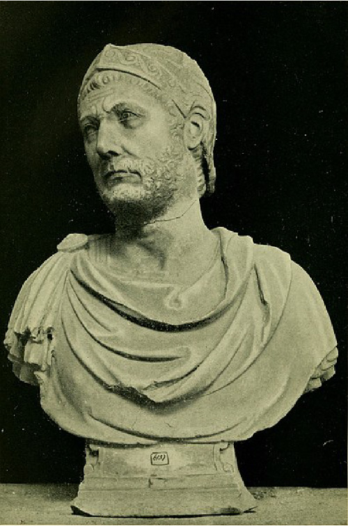
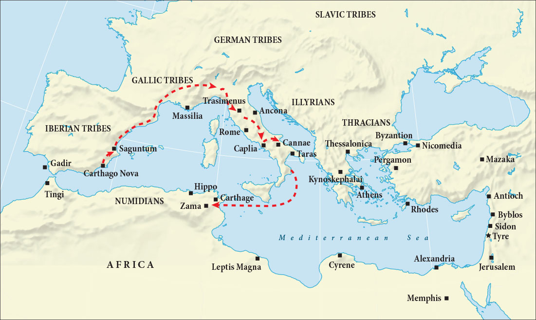
The most famous of these is the Second Punic or Hannibalic War, during which the Carthaginian general Hannibal Barca (Figure 9.20) invaded Italy with tens of thousands of soldiers and dozens of war elephants. For over a decade, Hannibal terrorized the Romans, destroying their armies at Trebia (218 BCE), Lake Trasimene (217 BCE), and, in one of the most lethal battle days in history, the village of Cannae in 216 BCE. The Carthaginians were unable to inflict a decisive defeat on the Romans, however, and the deadlock remained unbroken until the Roman general Publius Cornelius Scipio took the war to Carthage, forcing Hannibal to return from Italy to North Africa to defend it.
英語のヒント
最もよく知られているのは、第二次ポエニ戦争、別名ハンニバル戦争である。この戦争で、カルタゴの将軍ハンニバル・バルカ(図9.20)は、数万の兵士と数十頭の戦象を率いてイタリアへ侵入した。ハンニバルは10年以上ローマ人を恐れさせ、トレビア(前218年)、トラシメヌス湖(前217年)、カンナエ(前216年)でローマ軍を壊滅させた。カンナエの村での戦いは、歴史上でもとりわけ多くの命が1日で失われた戦闘の一つとなった。しかしカルタゴ軍は、ローマに決定的な敗北を与えられなかった。膠着状態が破れたのは、ローマの将軍プブリウス・コルネリウス・スキピオが戦場をカルタゴへ移したときだった。それによりハンニバルは、カルタゴを守るため、イタリアから北アフリカへ戻らざるを得なくなった。
Hannibal.ハンニバル
(credit: “Image from page 299 of ‘Republican Rome; her conquests, manners and institutions from the earliest times to the death of Caesar’ (1914)” by Havell/Internet Archive Book Images/Flickr, Public Domain) · Public Domain
Figure 9.20 This marble bust, believed to be of the Carthaginian general Hannibal Barca, was found in Capua, Italy, and may have been made in Hannibal’s lifetime. (credit: “Image from page 299 of ‘Republican Rome; her conquests, manners and institutions from the earliest times to the death of Caesar’ (1914)” by Havell/Internet Archive Book Images/Flickr, Public Domain)
図9.20 カルタゴの将軍ハンニバル・バルカを表したと考えられる大理石の胸像。イタリアのカプアで発見され、ハンニバルの存命中に制作された可能性がある。(クレジット:「Image from page 299 of ‘Republican Rome; her conquests, manners and institutions from the earliest times to the death of Caesar’ (1914)」、Havell/Internet Archive Book Images/Flickr、パブリックドメイン)
Carthage was finally defeated at the Battle of Zama in 202 BCE, a victory that earned Scipio the honorary name Africanus (Figure 9.21). Five decades later, urged on by the conservative senator Marcus Portius Cato (known to history as Cato the Censor), Rome returned to finish the job. The Third Punic War (149–146 BCE) ended with the destruction of Carthage. Tunis, some twenty miles inland, became the capital of Rome’s new African province.
英語のヒント
前202年、カルタゴはザマの戦いでついに敗れた。この勝利によって、スキピオは「アフリカヌス」という尊称を得た(図9.21)。50年後、歴史上「監察官カトー」と呼ばれる保守的な元老院議員マルクス・ポルキウス・カトーに促され、ローマはカルタゴとの決着をつけるため、再び戦争を起こした。第三次ポエニ戦争(前149〜前146年)は、カルタゴの破壊で終わった。約20マイル、約32キロメートル内陸のチュニスが、ローマの新しいアフリカ属州の首都となった。
Hannibal’s War (218–203 BCE).ハンニバルの戦争(前218〜前203年)
(attribution: Copyright Rice University, OpenStax, under CC BY 4.0 license) · CC BY 4.0
The absorption of North Africa into the Roman Empire greatly affected the Indigenous African peoples of the region. Carthage had needed very little from the peoples who lived beyond its hinterland. What food the population required was supplied by Carthaginian estates located on the outskirts of the city. Rome, on the other hand, needed a great deal from the Maghrebi interior, including grain and olive oil to feed the capital’s growing urban population. Decades of Roman development of the inland territory resulted in farms that, by the first decades of the Common Era, were generating hundreds of thousands of gallons of olive oil and millions of tons of wheat per year—all destined to feed the residents of Rome. This bounty earned North Africa the nickname “the breadbasket of Rome.”
英語のヒント
北アフリカがローマ帝国に組み込まれたことは、この地域の先住民に大きな影響を与えた。カルタゴは、都市の後背地よりも外側に暮らす人々から、ほとんど物資を必要としなかった。住民に必要な食料は、都市郊外にあるカルタゴ人の農園で賄われていた。それに対してローマは、首都で増え続ける都市人口を養うための穀物やオリーブ油など、多くのものをマグリブ内陸部に求めた。数十年にわたってローマが内陸を開発した結果、紀元後の初めの数十年間までに、農園は毎年、数十万ガロンのオリーブ油と数百万トンの小麦を生産するようになった。いずれもローマの住民を養うためのものだった。この豊かな産出によって、北アフリカは「ローマの穀倉」と呼ばれるようになった。
The intensification of agricultural production in the Maghreb led to the institution of individual land ownership and huge seasonal migrations of nomads and their animals to the coastal plains for work. To help control the flow of people during these periods and to protect crops from migrating cattle, the Romans established limes (lee-meis), or lines of fortified frontier posts that marked out the territorial limits of Roman occupation. Agricultural production also led to new growth for the old Phoenician coastal cities, which became commercial centers for shipping produce and livestock to Rome.
英語のヒント
マグリブで農業生産が集約化すると、土地の個人所有が制度として成立した。また、仕事を求めて遊牧民が家畜とともに沿岸平野へ移動する、季節ごとの大規模な移動が起こった。こうした時期の人の流れを管理し、移動する牛から作物を守るため、ローマ人はリメス、すなわち要塞化した国境拠点の列を設けた。それらは、ローマの占領地域の境界を示した。農業生産は、古いフェニキア沿岸都市にも新たな成長をもたらした。これらの都市は、農産物や家畜をローマへ送り出す商業の中心となった。
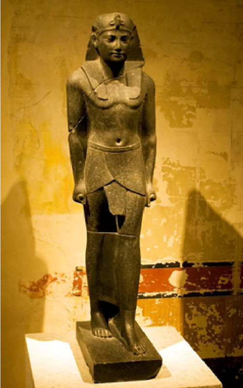
Eastern North Africa was also the site of great change in antiquity. In 332 BCE, Alexander the Great, king of Macedon in Greece, conquered Egypt, and before leaving to continue his advance into western Asia, he founded the great city of Alexandria on the Nile River. Following Alexander’s death in 323 BCE, his generals warred with each other over control of the empire and eventually divided the vast territory among themselves. One officer, Ptolemy, took Egypt and founded a dynasty that ruled it for the next three centuries. Of necessity, the Ptolemies styled themselves as pharaohs to demonstrate continuity from pharaonic times through Alexander to themselves (Figure 9.22). They adapted the Egyptian style partially because they were awed by the history and grandeur of Egypt and also because the Ptolemies wanted the people to see them as legitimate rulers of Egypt, not foreigners. Like all the Hellenistic (or Greek-like) monarchs of the three-hundred-year period following the death of Alexander, they encouraged Greeks from around the Mediterranean to settle in one of the three Greek city-states established by the Macedonian conquerors, including Alexandria. The Ptolemies also enticed Jewish people from Palestine to settle in northern Egypt, making Alexandria one of the most cosmopolitan cities in all antiquity.
英語のヒント
古代には、北アフリカ東部でも大きな変化が起きた。前332年、ギリシアのマケドニア王アレクサンドロス大王はエジプトを征服した。西アジアへの進軍を続けるために出発する前、ナイル川に大都市アレクサンドリアを建設した。前323年に彼が死ぬと、将軍たちは帝国の支配をめぐって争い、やがて広大な領土を分け合った。将軍の一人プトレマイオスはエジプトを掌握し、その後3世紀にわたって統治する王朝を開いた。プトレマイオス朝の王たちは、ファラオの時代からアレクサンドロスを経て自分たちへ統治が連続していることを示す必要から、ファラオを名乗った(図9.22)。エジプト式を取り入れたのは、その歴史と壮大さに畏敬を覚えたためでもあり、人々に外国人ではなく正統なエジプトの支配者と認めてほしかったためでもあった。アレクサンドロスの死後300年間に現れた、他のヘレニズム、すなわちギリシア風の君主たちと同じく、彼らは地中海各地のギリシア人に移住を勧めた。移住先は、アレクサンドリアを含め、マケドニアの征服者たちが築いた三つのギリシア都市国家のいずれかだった。プトレマイオス朝はパレスチナのユダヤ人も北エジプトへ招き寄せた。その結果、アレクサンドリアは、古代でも指折りの、多民族が集まる国際都市となった。
Ptolemy III.プトレマイオス3世
(credit: “Ptolemy III Euergetes” by “Szilas” in the Neues Museum, Berlin/Wikimedia Commons, Public Domain) · Public Domain
Figure 9.22 As the Macedonian Greek rulers of Egypt, the Ptolemies styled themselves as pharaohs. This basalt statue from about 220 BCE is believed to be of Ptolemy III and shows him wearing Egyptian clothes and a pharaonic headdress. (credit: “Ptolemy III Euergetes” by “Szilas” in the Neues Museum, Berlin/Wikimedia Commons, Public Domain)
図9.22 エジプトを支配したマケドニア系ギリシア人であるプトレマイオス朝の王たちは、ファラオを名乗った。前220年ごろのこの玄武岩像は、プトレマイオス3世と考えられ、エジプト式の衣服とファラオの頭飾りを着けている。(クレジット:「Ptolemy III Euergetes」、ベルリン新博物館で「Szilas」が撮影/Wikimedia Commons、パブリックドメイン)
The focal point of Greek culture in Egypt was the Museon or Museum of Alexandria. This “Home of the Muses” was much more than a place to see artifacts from the past; it was also the world’s largest library, housing some 700,000 scrolls representing all the knowledge of the known world. It had laboratories for the study of human anatomy and astronomy and was the home of dozens of intellectuals, who studied everything from geography and physics to literature and geometry. In many ways, it displaced the Academy at Athens as the ancient world’s center of learning. It was at the Museon, for example, that the canonical versions of Homer’s Iliad were identified, and that Eratosthenes developed his geographic understanding of the earth and estimated its circumference as between 24,500 and 29,000 miles (today we know it is 24,900 miles).
英語のヒント
エジプトのギリシア文化の中心は、アレクサンドリアのムセイオンだった。「ムーサたちの館」を意味するこの施設は、昔の遺物を見るだけの場所をはるかに超える存在だった。そこには世界最大の図書館もあり、当時知られていた世界の知識を集めた、約70万巻の巻物を収めていた。人体の解剖学や天文学を研究する施設を備え、数十人の学者たちが、地理学や物理学から文学や幾何学まで、さまざまな分野を研究した。多くの点で、アテネのアカデメイアに代わる古代世界の学問の中心となった。例えば、ホメロスの『イリアス』の標準となる本文が定められたのも、エラトステネスが地球についての地理学的理解を深め、その外周を2万4,500〜2万9,000マイルと推定したのも、ムセイオンである。現在では、地球の外周は約2万4,900マイル、約4万キロメートルと分かっている。
Day-to-day governance of Ptolemaic Egypt was in the hands of Egyptian officials and of Greek officials who brought Egyptian translators. To convincingly style themselves as pharaohs, the Ptolemies turned to religion. One of Ptolemy’s first acts as ruler of Egypt was to seize the body of Alexander the Great as it was being transported from Babylon home to Macedonia. Ptolemy had an elaborate tomb built for Alexander and made it a focal point of the capital at Alexandria. He then declared Alexander a god, a move fully in keeping with the status bestowed upon him in life by Egypt’s priests of Amun at Siwah in 332 BCE. In addition, Ptolemy had a temple dedicated to the new god Serapis built in the capital city. Serapis was an extraordinary deity demonstrating how astute Egypt’s Greek rulers were. A fusion of the Egyptian deities Osiris and Apis and the Greek deities Zeus and Helios, Serapis allowed the very different subjects of Ptolemaic Egypt to find common ground in worship. To further cement their position as Egypt’s legitimate rulers, the Ptolemies carried out the religious duties of the pharaoh, including dedicating new temples to Egyptian gods, visiting shrines throughout the country, and declaring themselves the inheritors of Alexander’s godlike mantle.
英語のヒント
プトレマイオス朝エジプトの日々の行政は、エジプト人官僚と、エジプト語の通訳を伴うギリシア人官僚が担った。ファラオという称号に説得力を持たせるため、王たちは宗教を利用した。プトレマイオスが支配者になって最初に行ったことの一つは、バビロンから故国マケドニアへ運ばれる途中だった、アレクサンドロス大王の遺体を奪うことだった。彼は大王のために豪華な墓を造らせ、首都アレクサンドリアの中心的な場所とした。次いで大王を神と宣言した。これは、前332年にシワのアメン神の祭司たちが生前の大王へ与えた地位と、完全に一致する措置だった。さらにプトレマイオスは、新しい神セラピスに捧げる神殿を首都に建てさせた。セラピスは、エジプトのギリシア人支配者たちの巧みさをよく示す、特異な神だった。エジプトの神オシリスとアピス、ギリシアの神ゼウスとヘリオスが融合したこの神は、大きく異なる背景を持つ臣民が、ともに崇拝できる対象となった。自分たちが正統な支配者であることをさらに確かなものにするため、プトレマイオス朝の王たちはファラオの宗教上の務めも果たした。エジプトの神々へ新たな神殿を捧げ、国内の聖所を訪れ、自らを、神に等しいアレクサンドロスの権威を受け継ぐ者と宣言した。
The last of the Ptolemies was Cleopatra VII (Figure 9.23). A brilliant politician with a strong character, Cleopatra spoke upward of a dozen languages and was the only Greek ruler of Egypt fluent in Egyptian. Politically ambitious, she was determined to preserve what autonomy she could in the face of Rome’s growing dominance of the Mediterranean. To this end, she had an affair with the Roman general and dictator Julius Caesar and bore him a child named Caesarion. When Caesar fell afoul of the Roman Senate (whose members suspected him of wanting to be king) and was assassinated in 44 BCE, Cleopatra shifted her affection to the inheritor of Caesar’s armies, Marc Antony. This strategy was ill-fated, however, because Marc Antony was increasingly embroiled in a conflict with Octavian, Caesar’s adopted son, which soon erupted in an all-out civil war between the two.
英語のヒント
プトレマイオス朝最後の支配者は、クレオパトラ7世だった(図9.23)。強い個性を持つ優れた政治家で、十数か国語を話し、エジプトを支配したギリシア系君主の中で唯一、エジプト語を流暢に話した。政治的野心の強い彼女は、地中海でローマの支配が拡大する中でも、保てる限りの自治を守ろうとした。そのためローマの将軍で独裁官のユリウス・カエサルと関係を持ち、カエサリオンという名の子を産んだ。カエサルは、王になろうとしていると疑う元老院の議員たちと対立し、前44年に暗殺された。するとクレオパトラは、カエサルの軍を引き継いだマルクス・アントニウスへ、愛情を向ける相手を変えた。だがこの戦略は不幸な結末を迎えた。アントニウスは、カエサルの養子オクタウィアヌスとの対立に、ますます深く巻き込まれていったからである。その対立は、まもなく二人の間の全面的な内戦に発展した。
Cleopatra.クレオパトラ
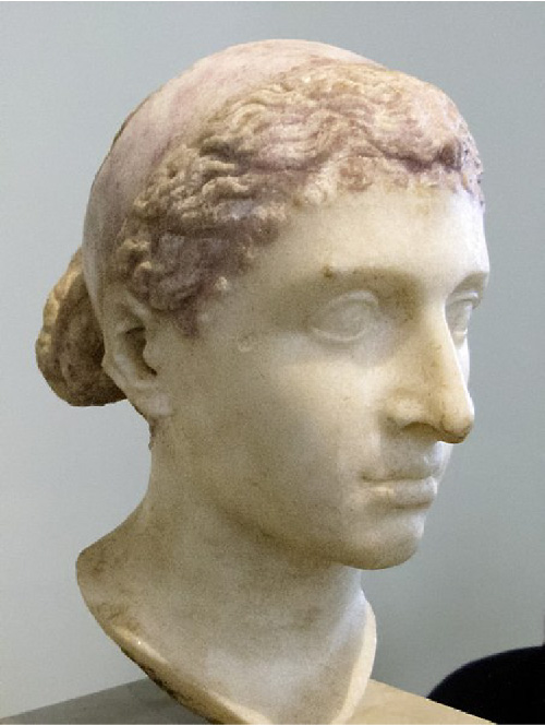
(credit: “Marble bust of Cleopatra VII of Egypt” by Altes Museum Berlin/Louis le Grand/Wikimedia Commons, Public Domain) · Public Domain
Figure 9.23 This marble bust of Cleopatra (69–30 BCE), the last of the Ptolemaic rulers of Egypt, was made during her lifetime. (credit: “Marble bust of Cleopatra VII of Egypt” by Altes Museum Berlin/Louis le Grand/Wikimedia Commons, Public Domain)
図9.23 エジプトのプトレマイオス朝最後の支配者クレオパトラ(前69〜前30年)の大理石胸像。彼女の存命中に制作された。(クレジット:「Marble bust of Cleopatra VII of Egypt」、ベルリン旧博物館/Louis le Grand/Wikimedia Commons、パブリックドメイン)