第9章古代のアフリカAfrica in Ancient Times
9.1 Africa’s Geography and Climate9.1 アフリカの地理と気候
Learning Objectives学習の目標
By the end of this section, you will be able to:
この節を学び終えると、次のことができるようになる。
Describe the way geography and climate shaped Africa’s ancient societies
地理と気候が、アフリカの古代社会をどのように形作ったか説明する。
Discuss the various Neolithic and hunter-gatherer societies in early Africa
初期アフリカのさまざまな新石器時代の社会や狩猟採集社会について論じる。
Geography played a vital part in shaping early human societies. Landscape, climate, wildlife, vegetation, and the availability of natural resources all helped influence what early societies looked like, whether they were nomadic units that kept animals and survived by hunting and foraging or settled communities that grew crops, tended herds or flocks, and built shelters. Such characteristics depended on factors like weather patterns and soil fertility, as well as the proximity of drinking water and toolmaking resources.
英語のヒント
地理は、初期の人間社会を形作るうえで重要な役割を果たした。地形、気候、野生動物、植生、天然資源の利用しやすさは、いずれも初期社会のあり方に影響した。それが、家畜を飼い、狩猟と採集で暮らす遊動集団であるか、作物を育て、家畜の群れの世話をし、住居を築く定住共同体であるかにかかわらずである。こうした社会の特徴は、天候の傾向や土壌の肥沃度、飲料水や道具の材料が近くにあるか、といった条件に左右された。
Well-watered regions in Africa, such as the grassy plains of the savannas and the northern and southern fringes of the continent, have historically produced environments that foster settled human communities. Here abundant rain, adequate forestation, and a host of wildlife provided conditions that could support ever-growing populations over long periods of time. More arid regions, such as the narrow transitional belts separating the savannas from Africa’s deserts, experience less rain and have less fertile soil, producing land that cannot be successfully farmed. These areas lent themselves to nomadism and the herding of grazing animals to provide many of the necessities of life, from milk and meat for food to leather and fur for clothing and bones for toolmaking. Throughout most of human history, geography has been an important factor in human development. As a result, exploring Africa’s diverse geography opens a window into the development of the earliest human civilization on the continent.
英語のヒント
サヴァンナの草原や大陸の北端・南端など、水に恵まれたアフリカの地域は、歴史を通じて人間の定住共同体を育む環境を生み出してきた。そこでは豊かな雨、十分な森林、多くの野生動物が、増え続ける人口を長期にわたって支えられる条件を整えた。これに対し、サヴァンナと砂漠を隔てる狭い移行帯のような、より乾燥した地域は、雨が少なく土壌の肥沃度も低いため、農耕がうまく成り立たない土地となる。こうした地域は、遊動生活や草を食べる動物の牧畜に適していた。家畜からは、食料となる乳と肉、衣服となる皮や毛皮、道具の材料となる骨など、多くの生活必需品が得られた。人類史の大部分を通じて、地理は人間社会の発展を左右する重要な要因だった。したがって、アフリカの多様な地理を探ることは、この大陸で最も早い人類文明がどのように発展したかを知る手がかりになる。
Geographic Diversity on the African Continentアフリカ大陸の地理的多様性
Owing to its position across the equatorial and subtropical latitudes of both the northern and southern hemispheres, Africa is home to a range of climates, including searing deserts, frozen glaciers, sweltering rainforests, and lush grasslands. These divergent environments exist because most of the continent lies between the Tropic of Cancer and the Tropic of Capricorn, in the tropical climate zone. Only its northernmost and southernmost fringes are beyond the tropical area.
英語のヒント
アフリカは赤道付近から南北両半球の亜熱帯までをまたいでいるため、焼けつく砂漠、凍った氷河、蒸し暑い雨林、緑豊かな草原など、多様な気候環境を持つ。こうした異なる環境が存在するのは、大陸の大部分が、北回帰線と南回帰線の間にある熱帯気候帯に位置するためである。熱帯から外れるのは、最北端と最南端の周縁部だけだ。
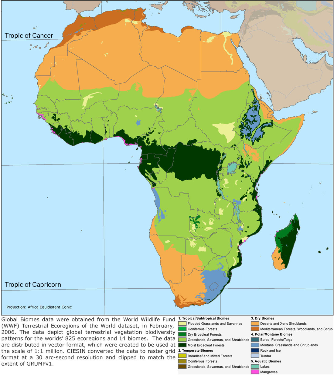
Across the center of Africa, stretching like a band from Guinea in the northwest to parts of Mozambique in the southeast, lies a swath of wet, tropical land subject to extremely heavy rainfall. Here we find the deep canopy and undergrowth of Africa’s equatorial rainforest (Figure 9.4). Centered on the Congo River Basin, the rainforest is densest in the present-day central state of the Democratic Republic of Congo. Here there is very little space between trees, resulting in thick layers of leaf covering that prevent much sunlight from reaching the forest floor. Approximately 386,000 square miles in extent, the Congo rainforest is the second largest in the world. Overall, it receives between sixty-three and seventy-eight inches of rain every year.
英語のヒント
アフリカの中央部には、北西のギニアから南東のモザンビークの一部へ、帯のように伸びる湿潤な熱帯地域があり、きわめて多くの雨が降る。そこには、アフリカの赤道雨林の厚い林冠と下生えが見られる(図9.4)。雨林はコンゴ川流域を中心に広がり、現在のアフリカ中部の国、コンゴ民主共和国で最も密生している。木々の間にはほとんど隙間がないため、葉が厚く重なり、林床に届く日光の多くを遮っている。約38万6,000平方マイルに及ぶコンゴ雨林は、世界で2番目に大きい。全体として、年間の降水量は63〜78インチに達する。
A Diverse Continent.多様な大陸。
(credit: modification of work “Africa: Biomes” by SEDACMaps/Flickr, CC BY 2.0) · CC BY 2.0
Figure 9.4 Africa has historically been home to a diverse range of climates and geographies, ranging from savannas and deserts to tropical rainforests and temperate zones. Notice that the bands of climate patterns above the equator are a near-mirror image of those below it. (credit: modification of work “Africa: Biomes” by SEDACMaps/Flickr, CC BY 2.0)
図9.4 アフリカには歴史を通じて、サヴァンナや砂漠から熱帯雨林や温帯まで、多様な気候と地理的環境が存在してきた。赤道より北の気候帯の配置が、南の配置をほぼ鏡に映したようになっていることに注目しよう。(出典:SEDACMaps「Africa: Biomes」を改変、Flickr、CC BY 2.0)
The Congo River, which forms the heart of the rainforest region, is the second-longest river in Africa; only the Nile is longer. The geographic differences between the environments of these rivers produced vastly different societies. The Nile River and its predictable flood patterns allowed Egyptian civilization to flourish for centuries. Large cities and grand architecture were features of the region due to readily available and plentiful food supplies, and hieroglyphs remained that left a clear and permanent record of key moments of its history. The Congo, however, flows through a tropical region, where dense forests created a very different kind of society, and the moist environment did not allow for recorded history but rather oral stories passed down through generations. Thus, while both regions had a human past, we know far more about one than we do about the other.
英語のヒント
雨林地域の中心をなすコンゴ川は、アフリカで2番目に長い川である。これより長いのはナイル川だけだ。二つの川の環境は地理的に異なり、その違いがきわめて異なる社会を生み出した。ナイル川と、その予測しやすい氾濫の周期は、エジプト文明が何世紀にもわたり繁栄することを可能にした。豊富な食料を容易に得られたため、この地域には大都市や壮大な建築が現れた。また、ヒエログリフが残り、歴史上の重要な出来事を明確で永続的な記録にとどめた。これに対し、コンゴ川が流れる熱帯地域では、密生する森林がまったく異なる種類の社会を生み出した。湿潤な環境では歴史を書き残すことが難しく、物語が世代を超えて口伝えで受け継がれた。したがって、両地域に人間の過去があったにもかかわらず、一方について分かっていることは、もう一方について分かっていることをはるかに上回る。
Africa’s tropical band is further divided into the monsoon area and the tropical savanna. Wetter than temperate savannas, tropical savannas are characterized by tall grasses, sparse trees, and greater rainfall and are found bordering the equator. The monsoon area is subject to seasonal wind changes that produce wetter and drier periods in isolated locations of the West African coast and the Central African interior. In the tropical savanna, on the other hand, rainfall diminishes considerably, and the dense stands of thickly layered trees that characterize the rainforest give way to forested pockets and lush grasslands.
英語のヒント
アフリカの熱帯は、さらにモンスーン地域と熱帯サヴァンナに分けられる。熱帯サヴァンナは温帯のサヴァンナより湿潤で、丈の高い草、まばらな樹木、より多い降水量を特徴とし、赤道付近に分布する。モンスーン地域では季節によって風向きが変わり、西アフリカ沿岸や中央アフリカ内陸の一部で、雨の多い時期と少ない時期が生じる。熱帯サヴァンナでは、それに対して雨量がかなり減り、雨林に特有の、層をなして密生する樹木に代わって、所々の森林や緑豊かな草原が現れる。
The savanna is a grassy plain that constitutes another of Africa’s immense biomes. A biome is a community of vegetation and wildlife adapted to a particular climate. At around five million square miles in size, the savanna covers almost half the surface of the continent and has been home to more people and history than any other part of Africa. Stretching from the warm and humid reaches of the rainforest to the torrid zone of the Sahara, it is wetter than the desert but drier than the rainforest and presents a striking geographic contrast to the landscapes of the desert and rainforest. Unlike those areas, the savanna landscape encompasses snow-capped mountains, vast expanses of grassy plains dotted with trees, and marshy tropical areas.
英語のヒント
サヴァンナは草に覆われた平原で、アフリカに広がる巨大な生物群系の一つをなす。生物群系とは、特定の気候に適応した植物と野生動物の集まりである。面積約500万平方マイルのサヴァンナは、大陸の表面のほぼ半分を覆い、アフリカのどの地域よりも多くの人々と歴史の舞台となってきた。暖かく湿った雨林の周辺からサハラの灼熱の地域まで伸び、砂漠よりは湿潤だが、雨林よりは乾燥している。その景観は、砂漠や雨林と鮮やかな地理的対照をなす。それらの地域とは異なり、サヴァンナの景観には、雪を頂く山々、木々が点在する広大な草原、湿地の広がる熱帯地域などが含まれる。
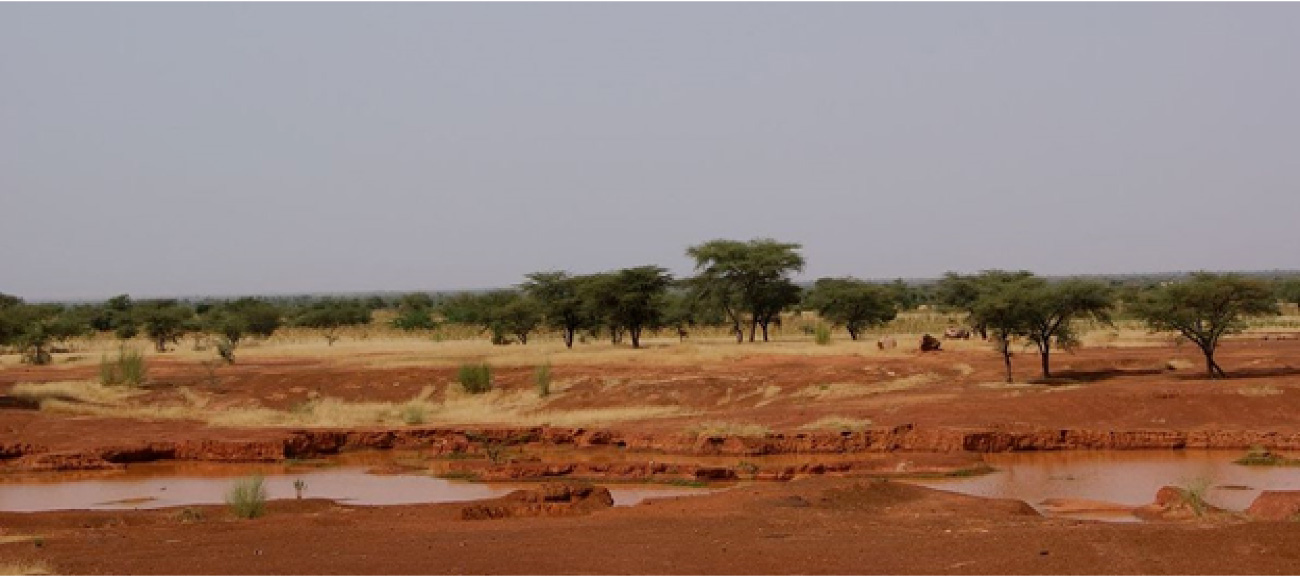
Geographers consider the savanna a region of transitions, with three successive belts running east–west: the Sahel, the tropical grassland savanna, and the woodland savanna. The Sahel, the northernmost band, is a semiarid belt between the Sahara and the grassland savannas to the south (Figure 9.5). It is the driest part of the savanna and experiences rain only periodically during six months of the year.
英語のヒント
地理学者は、サヴァンナを環境が段階的に移り変わる地域と捉えている。東西に走る三つの帯、すなわちサヘル、熱帯草原サヴァンナ、樹林サヴァンナが順に並ぶためだ。最も北のサヘルは、サハラと、その南にある草原サヴァンナとの間に位置する半乾燥帯である(図9.5)。サヴァンナの中で最も乾燥しており、1年のうち6か月の間に、雨が時折降るにすぎない。
The African Sahel.アフリカのサヘル。
(credit: modification of work “The road to Timbuktu in the Sahel, Mali” by Annabel Symington/Wikimedia Commons, CC BY 2.0) · CC BY 2.0
Figure 9.5 This photograph shows acacia trees that grow on the road to Timbuktu in the African Sahel, between the Sahara and the grasslands. (credit: modification of work “The road to Timbuktu in the Sahel, Mali” by Annabel Symington/Wikimedia Commons, CC BY 2.0)
図9.5 サハラと草原の間にあるアフリカのサヘルで、トンブクトゥへ向かう道沿いに生えるアカシアの木々。(出典:Annabel Symington「The road to Timbuktu in the Sahel, Mali」を改変、Wikimedia Commons、CC BY 2.0)
The people of the Sahel have historically been seminomadic—that is, they have adopted a mixed-farming system of crop production and the breeding and raising of livestock. Although the soil of the Sahel lacks sufficient nutrients to grow forests of trees, it is rich in the kind of nutrients that support the growth of plants in gardens as well as those that allow for small-scale farming and foster the growth of abundant grasses for the grazing of larger animals, particularly cattle and sheep. These herding animals also provide a key ingredient to help African farmers grow crops: manure. With the use of manure and the process of composting, the people of the region successfully navigate the challenges posed by their environment. Its conditions have tended to produce limited agriculture and smaller homesteads that are spaced farther apart to accommodate livestock. Many people of the region continue to live a seminomadic lifestyle rooted in animal husbandry. They do not cling to the past, a recurring myth about Africa; rather, their lifestyle is still the best way to harness what their climate provides.
英語のヒント
サヘルの人々は、歴史的に半遊動的な生活を送ってきた。つまり、作物生産と家畜の繁殖・飼育を組み合わせる混合農業を営んできたのである。サヘルの土壌には、樹木の森を育てるのに十分な養分はないが、菜園の植物を育てる養分は豊富にある。小規模な農業を可能にし、とりわけウシやヒツジなどの大型家畜が食べる草を豊かに育てる養分も含まれる。こうした家畜は、アフリカの農民が作物を育てるのに役立つ重要な材料、すなわち糞も供給する。人々は糞を利用して堆肥を作ることで、環境がもたらす難しさをうまく乗り越えている。この地域の条件のもとでは、農業の規模は限られ、家畜のための空間を確保するため、小さな農家の住まいが互いに離れて分布する傾向がある。今日も多くの人が、牧畜に根ざした半遊動生活を続けている。それは、アフリカについて繰り返される俗説がいうように、過去にしがみついているからではない。その暮らし方が、今も気候の恵みを最もよく生かせる方法だからである。
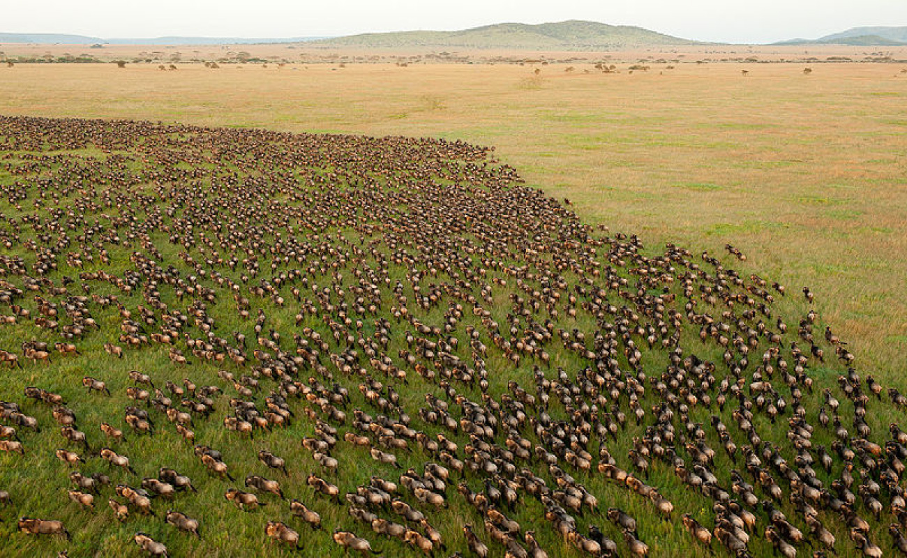
The Sahel gradually gives way in the south to a grassland savanna carpeted by short grasses and studded by scattered trees. At the extreme, this area can see as much as forty-eight inches of rain per year (the rainy season lasts from May to October). The most famous of all Africa’s tropical savannas is the Serengeti. Located in northern Tanzania, the Serengeti is a tremendously diverse ecosystem that witnesses some of the world’s largest mass migrations of animals. In January each year, for example, nearly 1.75 million wildebeests begin migrating out of the Ngorongoro Conservation Area at the southern extreme of the Serengeti, following the rainfall in search of food (Figure 9.6).
英語のヒント
南へ進むと、サヘルは徐々に、短い草がじゅうたんのように覆い、木々が点在する草原サヴァンナへと移り変わる。雨の多い場所では、年間48インチもの降水量がある。雨季は5月から10月まで続く。アフリカの熱帯サヴァンナで最も有名なのはセレンゲティだ。タンザニア北部に位置するセレンゲティは、きわめて多様な生態系であり、世界でも最大級の動物の大移動の舞台となる。たとえば毎年1月には、約175万頭のヌーが、セレンゲティ南端のンゴロンゴロ保全地域から移動を始め、雨を追いながら食べ物を探して進む(図9.6)。
Migrating Wildebeests.移動するヌー。
(credit: “Wildebeest Migration in Serengeti National Park, Tanzania” by Daniel Rosengren/Wikimedia Commons, CC BY 4.0) · CC BY 4.0
Figure 9.6 Every year between January and November, nearly two million wildebeests migrate in a great circular sweep across the Serengeti, arcing from northern Tanzania through southern Kenya and returning to the Ngorongoro Conservation Area nearly eleven months later. (credit: “Wildebeest Migration in Serengeti National Park, Tanzania” by Daniel Rosengren/Wikimedia Commons, CC BY 4.0)
図9.6 毎年1月から11月にかけて、約200万頭のヌーがセレンゲティを大きく円を描いて移動する。タンザニア北部からケニア南部を通り、約11か月後にンゴロンゴロ保全地域へ戻ってくる。(出典:Daniel Rosengren「Wildebeest Migration in Serengeti National Park, Tanzania」、Wikimedia Commons、CC BY 4.0)
Moving clockwise in a northerly direction toward the Masai Mara Reserve in Kenya, along the way these wildebeests encounter hundreds of thousands of other animals, including zebras and gazelles, that preceded them on their migration. They confront many obstacles and dangers on their trek, including rivers that hide dangerous hippopotamuses and crocodiles, not to mention numerous predators they face on land. When they finally arrive in Kenya, the female wildebeests birth around half a million calves. Their migration comes to an end in early November, after months spent grazing in the savanna grasslands of the Masai Mara Reserve. The herds then migrate south on their return trip to northern Tanzania from Kenya.
英語のヒント
これらのヌーは、ケニアのマサイ・マラ保護区を目指し、北へ向かって時計回りに移動する。その途中で、シマウマやガゼルなど、先に移動を始めた数十万頭の動物たちに出会う。長い旅では、危険なカバやワニが潜む川をはじめ、多くの障害や危険に直面する。陸上で待ち受ける多数の捕食者もいうまでもない。ようやくケニアに着くと、雌のヌーはおよそ50万頭の子を産む。マサイ・マラ保護区のサヴァンナ草原で何か月も草を食べて過ごし、11月初めに移動の終点を迎える。その後、群れはケニアからタンザニア北部への帰路につき、南へ移動する。
The woodland savanna is the last of the belts separating the great northern desert from the equatorial rainforest. It is characterized by tall grasses occasionally interrupted by scattered trees, and corridors of gallery forests along streams and rivers. The area receives plentiful rainfall, usually nine months of the year, and farmers in the region cultivate palm oil trees and root crops such as yams.
英語のヒント
樹林サヴァンナは、北方の大砂漠と赤道雨林を隔てる帯の最後のものだ。丈の高い草原に木々がまばらに立ち、小川や川沿いには帯状の河畔林が伸びる。この地域は雨量が豊富で、通常は1年のうち9か月に雨が降る。農民はアブラヤシや、ヤムイモなどの根菜類を栽培する。
As distance from Africa’s tropical zone increases, so too does the unpredictability of the rainfall. Progressively, to the north and south of this region, the bands of tropical and temperate climate give way to increasingly drier environments. Limits on resource availability in the more arid parts of Africa, as elsewhere in the world, have necessarily restricted the growth and expansion of civilizations. Regions that lack accessible supplies of water in the form of underground aquifers or wells, rivers, or lakes or that receive little rainfall are ill-suited to farming. Because only farming can support larger human population centers, the lack of accessible water is a barrier to human settlement. This helps explain why no large civilizations emerged in the more obviously arid parts of Africa, such as the Sahara and the Kalahari Desert and also why certain of the drier transitional zones between savanna and desert remain so thinly populated.
英語のヒント
アフリカの熱帯から離れるにつれて、雨の降り方もいっそう予測しにくくなる。この地域の北と南では、熱帯・温帯の帯状の地域が、次第に乾燥の強い環境へ移り変わる。アフリカのより乾いた地域では、世界の他の地域と同様に、利用できる資源の限界が、文明の成長と拡大を必然的に制約してきた。地下の帯水層や井戸、川、湖から水を得られない地域や、雨がほとんど降らない地域は、農耕に向かない。大きな人口の集中を支えられるのは農耕だけであるため、利用しやすい水がないことは、人間の定住の障壁になる。これによって、サハラやカラハリ砂漠のような、明らかに乾燥した地域で大規模な文明が生まれなかった理由の一端が分かる。また、サヴァンナと砂漠の間の乾燥した移行帯の一部で、今なお人口密度が非常に低いことも説明できる。
The Sahel transitions to desert in the extreme north of the savanna belt. Deserts are the sunniest and driest parts of the continent. Africa’s largest desert—in fact, the world’s—is the Sahara. At 3.6 million square miles, about the size of the United States, the Sahara covers much of North Africa (excluding the fertile coastal zones along the Mediterranean and the Nile delta) and stretches from the Red Sea in the east to the Atlantic Ocean in the west. The Sahara has not always been a vast desert, however. In the period following the last Ice Age, this was a lush region that experienced monsoon-like weather conditions and was home to pastoralists and large herds of cattle. In fact, the earliest evidence we have of the domestication of cattle was discovered on Saharan rock art. But between 6000 and 2500 BCE, the region witnessed a great drying, which resulted in the retreat of the rainforest and the expansion of desert zones. These changes prompted crises for the human inhabitants of the formerly tropical zones, who found their old hunting and gathering techniques no longer suitable in the changed environment.
英語のヒント
サヘルは、サヴァンナ帯の北の端で砂漠に変わる。砂漠は大陸で最も日差しが強く、乾燥した地域だ。アフリカ最大、実際には世界最大の砂漠はサハラである。面積は360万平方マイルとアメリカ合衆国ほどもあり、地中海沿岸の肥沃な地域とナイル・デルタを除く北アフリカの大部分を覆う。東の紅海から西の大西洋まで広がっている。しかし、サハラがいつも広大な砂漠だったわけではない。最終氷期後の時期には、モンスーンに似た天候を持つ緑豊かな地域で、牧畜民やウシの大きな群れが暮らしていた。実際、ウシの家畜化について現存する最も古い証拠は、サハラの岩絵で発見された。ところが、前6000〜前2500年に、この地域では大規模な乾燥化が起こり、雨林が後退し、砂漠地帯が広がった。かつての熱帯地域に暮らしていた人々は、この変化によって危機に直面した。以前の狩猟採集の方法が、変わってしまった環境では、もはや適さなくなったのである。
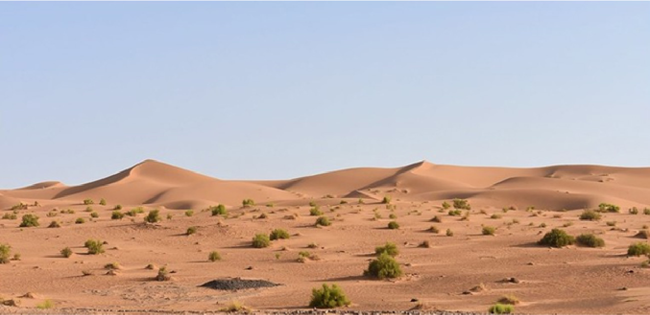
This desertification is what produced the modern Sahara, which receives less than an inch of precipitation per year with variations of some regions experiencing up to four inches per year, while other places go decades with no rain(Figure 9.7). The average daytime high is 99°F, and average nighttime lows are as cool as 68°F, but highs can reach up to 120°F during the warmer months from April to June, and lows can dip below 37°F in the cooler period between December and January. The only plants that can survive in this hostile environment rely on the water that collects in dry riverbeds during the exceptional periods of rain, but they are few.
英語のヒント
この砂漠化が、現在のサハラを生み出した。年間降水量は1インチ未満だが、地域差があり、年間4インチに達する所もあれば、何十年も雨が降らない所もある(図9.7)。昼間の最高気温は平均99°F、夜間の最低気温は平均68°Fまで下がる。ただし、暖かい4〜6月には最高気温が120°Fに達することがあり、涼しい12〜1月には最低気温が37°Fを下回ることもある。この厳しい環境で生き残れる植物は、まれに雨が降ったとき、普段は干上がっている川床に集まる水に頼っている。しかし、そのような植物はごく少ない。
The Sahara Desert.サハラ砂漠。
(credit: modification of work “Sahara” by “Not So Dusty”/Flickr, CC BY 2.0) · CC BY 2.0
Figure 9.7 Aside from its rare oases, the Sahara is one of the most inhospitable places on earth, with sparse rainfall and extreme temperature swings from day to evening. (credit: modification of work “Sahara” by “Not So Dusty”/Flickr, CC BY 2.0)
図9.7 まれなオアシスを除けば、サハラは地球上でも特に人が暮らしにくい場所の一つである。雨がほとんど降らず、日中から夜にかけて気温が大きく変動する。(出典:「Not So Dusty」「Sahara」を改変、Flickr、CC BY 2.0)
Among the Sahara’s thousand-foot-tall sand dunes, hard stony surfaces, and vast mountain ranges with peaks as high as eleven thousand feet are oases, green dots of civilization formed around underground water sources that reach the surface via wells or springs. Although together these oases take up only eight hundred square miles—about 0.02 percent of the desert’s total landmass—they are home to some three-quarters of the people living in the desert. The remainder of the population are nomads, including the Tuareg and Teda. These peoples engage in a range of economic activities, such as farming and herding, but on a severely restricted basis. Pasturage, for example, exists only in marginal areas such as mountain borders and the somewhat moister areas to the west, limitations that govern the herders’ nomadic lifestyle.
英語のヒント
高さ1,000フィートの砂丘、硬い石の地面、高い峰では1万1,000フィートに達する広大な山脈が広がるサハラには、オアシスが点在する。地下水が井戸や泉を通して地表に達する場所の周囲に生まれた、文明の緑の点である。これらのオアシスの面積は、合わせてもわずか800平方マイル、砂漠全体の約0.02%にすぎないが、砂漠に暮らす人々のおよそ4分の3が集まっている。残りの人々は遊牧民で、トゥアレグ人やテダ人などが含まれる。彼らは農業や牧畜をはじめとする多様な経済活動に従事するが、その規模は厳しく制約される。たとえば放牧地は、山地の縁や、西方のいくらか湿り気の多い場所など、限られた周辺地域にしかない。こうした制約が、牧畜民の遊動生活を左右している。
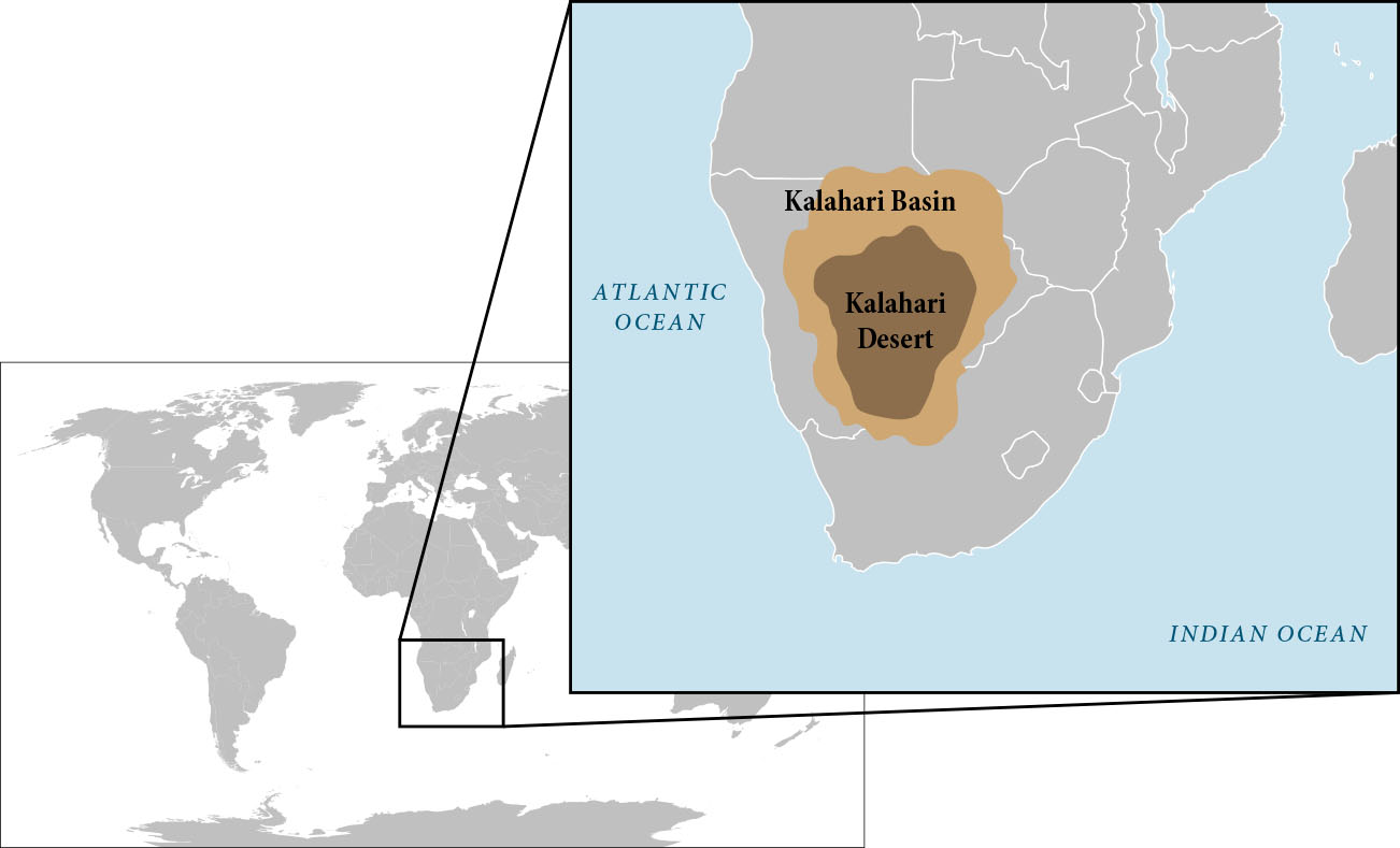
As famous as it is, the Sahara is not Africa’s only desert; there is also a desert region in the African Horn (the area corresponding to Somalia, Ethiopia, and northern Kenya), as well as the Namib and the Kalahari Desert, Africa’s great southwestern desert (Figure 9.8). The Kalahari Desert presents perhaps the most interesting contrast to the extremes of the Sahara.
英語のヒント
これほど有名なサハラも、アフリカ唯一の砂漠ではない。「アフリカの角」、すなわちソマリア、エチオピア、ケニア北部に当たる地域にも砂漠がある。さらにナミブ砂漠や、南西部の大砂漠カラハリも存在する(図9.8)。サハラの極端な環境との対照という点で、おそらく最も興味深いのはカラハリ砂漠だ。
The Kalahari Desert.カラハリ砂漠。
(credit: modification of work “Kalahari Desert and Kalahari Basin map” by “Quadell”/Wikimedia Commons, Public Domain) · Public Domain
Figure 9.8 The Kalahari in southwest Africa is the second largest of Africa’s deserts. (credit: modification of work “Kalahari Desert and Kalahari Basin map” by “Quadell”/Wikimedia Commons, Public Domain)
図9.8 アフリカ南西部のカラハリは、大陸で2番目に大きい砂漠である。(出典:「Quadell」「Kalahari Desert and Kalahari Basin map」を改変、Wikimedia Commons、パブリックドメイン)