第8章古代の南北アメリカThe Americas in Ancient Times
Complex Societies in North America北アメリカの複雑な社会
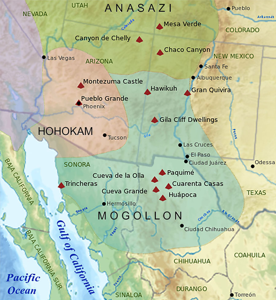
After many centuries of cultivating maize to supplement their hunter-gatherer lifestyle, around 500 BCE, groups in the American Southwest began to establish permanent villages supported by farming. Over the next few centuries, settled villages with permanent homes supplied with large storage pits for maize proliferated across the region. The agricultural peoples of these villages are often subdivided into three major cultural groups: the Mogollon tradition in the south, the Hohokam tradition in the west, and the Anasazi or Ancestral Pueblo tradition in the north (Figure 8.38). They were in contact with each other and shared a number of similarities. Their early settlements consisted of a number of oval and circular pit houses, partly underground and built of wooden poles covered in dried mud. These could be ventilated by rooftop openings accessible by internal ladders. Such homes were especially well suited to the sun-drenched environment and provided a cool escape from the hot outside temperatures. They also efficiently preserved heat during winter, when conditions could get exceedingly cold.
英語のヒント
何世紀もの間、狩猟採集生活を補うためにトウモロコシを育てた後、前500年ごろ、アメリカ南西部の集団は、農耕に支えられる恒久的な村を築き始めた。その後の数世紀に、トウモロコシ用の大きな貯蔵穴を備える、常設の家々からなる村が、地域全体に増えていった。これらの村の農耕民は、一般に三つの主要な文化集団に分けられる。南のモゴヨン、西のホホカム、北のアナサジ、または古代プエブロ文化である(図8.38)。互いに交流し、数多くの共通点を持っていた。初期の集落は、楕円形や円形の竪穴住居から成っていた。地面を一部掘り下げ、木の柱に乾いた泥を塗って造ったもので、内側の梯子で行ける屋根の開口部から換気できた。この家は、強い日差しの環境に特によく適しており、暑い外気から逃れられる涼しい場所となった。また、極端に寒くなることもある冬には、効率よく暖かさを保った。
Traditions of the American Southwest.アメリカ南西部の文化
(credit: modification of work “Regions of ancient regional tribes in the southwestern United States and Northwestern Mexico” by “Ricraider”/Wikimedia Commons, CC BY 3.0) · CC BY 3.0
Figure 8.38 Three large and distinct cultural traditions emerged in the Southwest beginning around 500 CE: the Mogollon, the Hohokam, and the Anasazi. (credit: modification of work “Regions of ancient regional tribes in the southwestern United States and Northwestern Mexico” by “Ricraider”/Wikimedia Commons, CC BY 3.0)
図8.38 500年ごろから、南西部には、モゴヨン、ホホカム、アナサジという、三つの大きく異なる文化的伝統が現れた。(出典:「Ricraider」「Regions of ancient regional tribes in the southwestern United States and Northwestern Mexico」を改変、Wikimedia Commons、CC BY 3.0)
Settlements varied in size from a handful of homes to as many as sixty. The design of the dwellings and the complexity of the settlements varied as well, with both generally increasing over time. By around 700, for example, large ceremonial meeting-house structures called kivas had become common in the central and northern areas. These were likely the local centers of religious ceremonies and civic life. In the centuries after 700, the settlements evolved into larger collections of multiroom structures built of dried adobe clay and stone. By 900, similar permanent settlements dotted the larger southwestern landscape, including in modern New Mexico, Arizona, Colorado, Utah, Texas, and the Mexican state of Chihuahua.
英語のヒント
集落の規模は、数軒の家から、多いものでは60軒まで、さまざまだった。住居の設計や集落の複雑さも異なり、どちらも一般に、時とともに発展した。例えば700年ごろまでには、中央部と北部で、キヴァと呼ばれる大きな儀礼用の集会所が広く見られるようになった。おそらく、地域の宗教儀式や共同体生活の中心だった。700年以降の数世紀に、集落は、乾かした日干しレンガや石でできた、複数の部屋を持つ建物の、より大きな集まりへと発達した。900年までには、現在のニューメキシコ、アリゾナ、コロラド、ユタ、テキサス、メキシコのチワワ州など、南西部の広い範囲に、同じような定住集落が点在していた。
Some of the most impressive settlements that remain include Pueblo Bonito in New Mexico, Cliff Palace in Colorado, and Casas Grandes in Chihuahua. Pueblo Bonito in Chaco Canyon began to expand into the large masonry settlement visible in its ruins today around 800, when its residents abandoned their pit houses for the larger pueblo-style rooms. Pueblo architecture used stone or wooden frames covered in adobe clay. The houses and other buildings made in this way tended to have flat roofs that could be used as terraces.
英語のヒント
今も残る見事な集落には、ニューメキシコのプエブロ・ボニート、コロラドのクリフ・パレス、チワワのカサス・グランデスがある。チャコ・キャニオンのプエブロ・ボニートが、現在の遺跡に見られる大きな石造集落へと拡大し始めたのは、800年ごろだった。住民は竪穴住居を離れ、より大きなプエブロ式の部屋へ移った。プエブロ建築は、石や、木の骨組みに日干しの粘土をかぶせたものを使った。この方法で造られた家やその他の建物は、テラスとして使える平らな屋根を持つことが多かった。
At Pueblo Bonito, the houses were organized in a U-shape around the old pits from the pit houses, which were then used as kivas. This settlement reached its peak around 1000, which may have meant a modest population of about one hundred people, though its six hundred pueblo rooms could have housed as many as one thousand. In addition to being an important agricultural settlement, Pueblo Bonito was a major ceremonial center and likely attracted groups from the surrounding area for significant events. Some residents were clearly of particular importance, as indicated by the 130 burial sites and associated objects discovered there.
英語のヒント
プエブロ・ボニートでは、かつての竪穴住居の穴を囲むように、家々がU字形に配置された。その穴は、その後キヴァとして使われた。集落は1000年ごろに最盛期を迎えた。600のプエブロ式の部屋には、1,000人もの人々を収容できたかもしれないが、実際の人口は約100人という、小規模なものだった可能性がある。プエブロ・ボニートは重要な農業集落であると同時に、大きな儀礼の中心地でもあった。重要な行事には、周囲から集団が集まったと考えられる。そこで発見された130の埋葬と関連する品々が示すように、住民の中には、特別に重要な人物がいたことが明らかである。
In addition to Pueblo Bonito, at least seventy other communities of varying sizes were scattered across the larger Chaco Canyon area. The total population of these settlements may have included as many as 5,500 people. Connections between them are suggested by shared pottery and architectural styles, and by the network of roads that pass through some settlements while radiating outward from the canyon like spokes on a wheel.
英語のヒント
プエブロ・ボニートに加え、チャコ・キャニオンの広い地域には、規模の異なる少なくとも70の共同体が点在していた。これらの集落の総人口は、5,500人に達していた可能性がある。土器や建築の様式が共通すること、また、峡谷から車輪の輻のように外へ放射状に延び、一部の集落を通る道路網があることから、集落どうしのつながりがうかがえる。
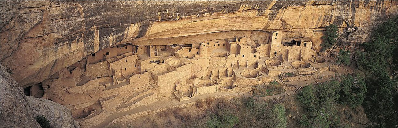
A long period of drought after 1130 led the residents of Chaco Canyon and Pueblo Bonito to abandon their settlements for other areas that promised sustenance. By about 1200, the old settlements were empty. Some eighty miles to the north in Mesa Verde, conditions were wetter and natural resources more plentiful, and groups there built a number of impressive cliffside dwellings. Construction of one of the largest settlements, today called Cliff Palace, began around 1190. Archaeologists believe this settlement was made as a defensive measure when competition for scarce resources was becoming more intense. Similar cliffside settlements were built in other places in the region for the same reason. Cliff Palace had twenty-three kivas and 220 rooms made of sandstone, mortar, and wood. They extend up the side of the cliff, some towering twenty-six feet tall (Figure 8.39). Like Pueblo Bonito, Cliff Palace also likely had a population of about one hundred people. And for just over a century, the settlement prospered, until expanding drought conditions forced the residents to abandon it and the many other Mesa Verde settlements around 1300.
英語のヒント
1130年以降の長い干ばつによって、チャコ・キャニオンやプエブロ・ボニートの住民は、暮らしを支える食料を得られそうな、ほかの地域へ集落を捨てて移った。1200年ごろまでに、古い集落は無人になっていた。約80マイル北のメサ・ヴェルデでは、水分や自然資源がより豊かで、そこで人々はいくつもの見事な崖沿いの住居を築いた。最大級の集落の一つで、現在クリフ・パレスと呼ばれるものの建設は、1190年ごろに始まった。考古学者は、乏しい資源をめぐる競争が激しくなる中、防衛策として造られたと考えている。同じ理由から、この地域のほかの場所にも、似た崖沿いの集落が築かれた。クリフ・パレスには、砂岩、モルタル、木で造られた220の部屋と、23のキヴァがあった。建物は崖に沿って積み重なり、高さ26フィートに達するものもある(図8.39)。プエブロ・ボニートと同じく、クリフ・パレスの人口も約100人だった可能性が高い。集落は1世紀余り繁栄したが、干ばつが広がったため、1300年ごろ、住民はここや、メサ・ヴェルデのほかの多くの集落を離れることを余儀なくされた。
The Cliff Palace.クリフ・パレス
(credit: “Trail of the Ancients - Cliff Palace at Mesa Verde National Park” by U.S. National Archives and Records Administration/Wikimedia Commons, Public Domain) · Public Domain
Figure 8.39 Construction of the impressive cliffside dwellings at the Cliff Palace site in modern southwest Colorado began about 1190. Residents used wooden ladders to reach their elevated homes. (credit: “Trail of the Ancients - Cliff Palace at Mesa Verde National Park” by U.S. National Archives and Records Administration/Wikimedia Commons, Public Domain)
図8.39 現在のコロラド州南西部にあるクリフ・パレスの、見事な崖沿いの住居の建設は、1190年ごろに始まった。住民は木の梯子を使い、高い位置の家へ出入りした。(出典:U.S. National Archives and Records Administration「Trail of the Ancients - Cliff Palace at Mesa Verde National Park」、Wikimedia Commons、パブリックドメイン)
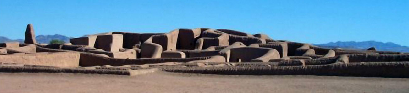
Far to the south of Mesa Verde were the settlements of the Mogollon tradition. One of the more impressive is known today as Casas Grandes or Paquimé (Figure 8.40). Set in a flat arid portion of northern Chihuahua, Mexico, near the modern U.S. border, Casas Grandes emerged as an important agricultural settlement in the fourteenth century. Far more agriculturally productive than its northern Anasazi neighbors, Casas Grandes may have had a population of almost 2,300 people at its height. These people lived in adobe structures clustered close together and surrounded by a large enclosure wall.
英語のヒント
メサ・ヴェルデからはるか南には、モゴヨン文化の集落があった。特に見事なものの一つが、現在カサス・グランデス、またはパキメと呼ばれる遺跡である(図8.40)。現在の米国との国境に近い、メキシコのチワワ州北部の、平らで乾燥した土地に位置し、14世紀に重要な農業集落として現れた。北隣のアナサジより農業生産力がはるかに高く、最盛期には、ほぼ2,300人の人口があった可能性がある。人々は、密集して建つ日干しレンガの建物に住み、その周囲は大きな囲い壁で守られていた。
Casas Grandes.カサス・グランデス
(credit: “Wide view of Paquime” by Luis Serrano/Wikimedia Commons, Public Domain) · Public Domain
Figure 8.40 The ruins of Casas Grandes stand as a testament to the productivity of this once-large city. Its population—more than two thousand at its height in the fourteenth century—was far larger than that at settlements like Pueblo Bonito or Cliff Palace. (credit: “Wide view of Paquime” by Luis Serrano/Wikimedia Commons, Public Domain)
図8.40 カサス・グランデスの遺跡は、かつて大都市だったこの場所の生産力を物語る。14世紀の最盛期には2,000人を超えた人口は、プエブロ・ボニートやクリフ・パレスのような集落より、はるかに多かった。(出典:Luis Serrano「Wide view of Paquime」、Wikimedia Commons、パブリックドメイン)
Because of its adobe design, Casas Grandes bears a superficial resemblance to some Anasazi communities. But the site actually has more in common with the Mesoamerican civilizations far to its south. For example, there are no kivas at Casas Grandes, but there are ruins of a large I-shaped Mesoamerican-style ball court. Among the valuable trading goods produced at Casas Grandes were colorful macaw feathers commonly used in Anasazi rituals. These indicate that trading networks existed between Casas Grandes and the Anasazi to their north. By the start of the fifteenth century, however, Casas Grandes was entering a period of decline; by the end of the century, it had been abandoned.
英語のヒント
日干しレンガを使う設計のため、カサス・グランデスは、外見上はアナサジの一部の共同体と似ている。しかし、実際には、はるか南のメソアメリカ文明と、より多くの共通点を持つ。例えば、キヴァはないが、大きなI字形のメソアメリカ式球戯場の遺構がある。カサス・グランデスで生産された貴重な交易品には、アナサジの儀礼によく使われる、色鮮やかなコンゴウインコの羽根があった。これは、カサス・グランデスと、北のアナサジの間に交易網があったことを示す。しかし、15世紀初めまでに、カサス・グランデスは衰退期へ入り、その世紀末までには放棄されていた。
Around the same time that settled agricultural communities were becoming common in the Southwest, the Eastern Woodlands region was going through its own cultural transformations. On the former site of the Adena and Hopewell traditions, a new mound-building culture called the Mississippian tradition began to emerge around 700. This large and sophisticated culture constructed some of the biggest and most impressive of all the ceremonial mounds in the region.
英語のヒント
南西部で農耕を営む定住共同体が広く見られるようになったのと同じころ、東部森林地帯も、独自の文化的な変化を経験していた。かつてアデナやホープウェルの文化があった地域では、700年ごろ、ミシシッピ文化と呼ばれる新たなマウンド築造文化が現れ始めた。この大きく高度な文化は、地域の儀礼用マウンドの中でも、最大級で、特に見事なものを築いた。
The Mississippian tradition was apparently sparked by the adoption of maize agriculture from much farther south. Maize may have arrived in the Eastern Woodlands as early as 800 and was adopted by groups already accustomed to farming edible plants like sunflowers and bottle gourds. By 1000, its cultivation had become common throughout the region, even among groups that had not used agricultural techniques before. Bean cultivation was also spreading around the Eastern Woodlands, and at about the same time, people in the area began to use the bow and arrow, especially for hunting small animals like birds.
英語のヒント
ミシシッピ文化は、はるか南からトウモロコシ栽培を取り入れたことが、きっかけになったようである。トウモロコシは、早ければ800年には東部森林地帯へ届き、すでにヒマワリやヒョウタンなどの食用植物の栽培に慣れていた集団に、取り入れられた可能性がある。1000年までには、それまで農耕を行っていなかった集団も含め、地域全体で広く栽培されるようになった。豆の栽培も広がっていた。同じころ、人々は弓矢を使い始め、とりわけ鳥などの小動物の狩猟に用いた。
Combined, these changes brought about a major cultural shift in the Eastern Woodlands marked by the appearance of large settled agricultural communities and the spread of common cultural, architectural, and technological practices. A number of settlements arose throughout the Mississippi River valley and as far away as Georgia and Florida. Most were small chiefdoms built around one or just a few earthen mounds. Occasionally, smaller settlements were grouped into larger chiefdoms, and in a few important places, the settlements were exceptionally large, with populations in the thousands. Archaeological discoveries reveal that these settlements communicated and traded with each other, maintaining large trading networks that linked their many urban centers. Artifacts have been found many hundreds of miles from the site of their manufacture, and common architectural and artistic details suggest that cultural ideas too were disseminated far and wide.
英語のヒント
こうした変化が組み合わさり、東部森林地帯では大きな文化的転換が起きた。大きな定住農耕共同体が現れ、共通する文化、建築、技術の実践が広がったのである。ミシシッピ川流域全体から、遠くはジョージアやフロリダまで、集落が生まれた。大部分は、一つか少数の土のマウンドを中心とする、小さな首長制社会だった。小集落が、より大きな首長制社会にまとめられる場合もあった。少数の重要な場所では、人口が数千人に及ぶ、例外的に大きな集落ができた。考古学的な発見から、これらの集落が互いに交流し、交易していたことがわかる。多くの都市中心地を結ぶ、大きな交易網を維持していたのである。遺物は、製作地から何百マイルも離れた場所で発見される。建築や美術の細部の共通性は、文化的な考え方もまた、広い範囲に伝わったことを示唆する。
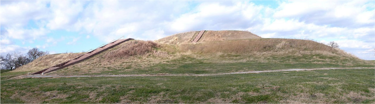
The Mississippian site at Cahokia near modern St. Louis is possibly the most elaborate and important researched thus far. Earlier settlements nearby were smaller and date to about 600. But around 1050, the large urban center of Cahokia began to emerge, reaching its peak about 1250 before experiencing a gradual decline. At its height, Cahokia and its surrounding settlements covered nearly four square miles, had a population as large as sixteen thousand people, and included well over one hundred different mounds. At the center was a network of large mounds organized around a 100-foot-tall temple mound, built in stages with a wooden structure at its summit and a large staircase leading up from the surrounding plaza (Figure 8.41). Wood and thatch houses of various sizes radiated out from the central plaza and into the surrounding maize fields. Around the central complex of mounds and the homes of the elite was a large defensive wall, with watchtowers spaced at intervals around it.
英語のヒント
現在のセントルイス近くにある、ミシシッピ文化の遺跡カホキアは、これまで研究された中でも、最も複雑で重要なものかもしれない。近隣の、600年ごろにさかのぼる初期の集落は、もっと小さかった。しかし、1050年ごろになると、カホキアという大きな都市中心地が現れ始めた。1250年ごろに頂点へ達し、その後、次第に衰退した。最盛期には、カホキアと周囲の集落は、ほぼ4平方マイルを占め、人口は1万6,000人に達し、100基を大きく超える、さまざまなマウンドを含んでいた。中央には、高さ100フィートの神殿の土壇を軸に、大きなマウンド群が配置された。土壇は段階的に築かれ、頂上に木造建築、周囲の広場から上る大きな階段があった(図8.41)。木と茅で造った大小の家が、中央広場から周囲のトウモロコシ畑へと、放射状に広がった。中央のマウンド群と支配層の住居は、大きな防壁に囲まれ、壁には一定の間隔で見張り塔が設けられていた。
Monks Mound at Cahokia.カホキアのモンクス・マウンド
(credit: “Monk’s mound panorama” by Tim Vickers/Wikimedia Commons, Public Domain) · Public Domain
Figure 8.41 The terraced remains of Monks Mound at Cahokia, completed around 1100, stand today as the largest human-made earthen mound in North America. It rises almost one hundred feet above the surrounding landscape. (credit: “Monk’s mound panorama” by Tim Vickers/Wikimedia Commons, Public Domain)
図8.41 1100年ごろに完成したカホキアのモンクス・マウンドは、段状の姿を今に残す、北アメリカ最大の人工の土壇である。周囲の地面から、ほぼ100フィートの高さにそびえる。(出典:Tim Vickers「Monk’s mound panorama」、Wikimedia Commons、パブリックドメイン)
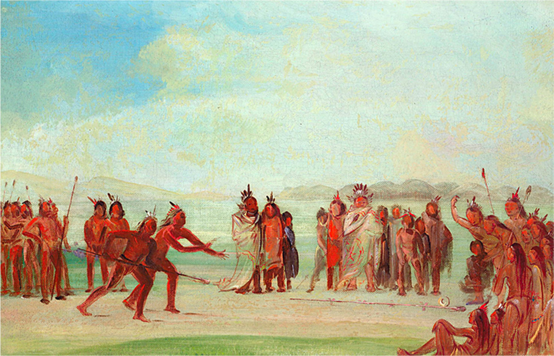
Other mounds at Cahokia served as burial mounds and platforms for ritual performances. Some of the rituals included human sacrifice, not unlike those common in Mesoamerica. One of the excavated mounds at the site contained the remains of several dozen sacrificial victims. At the base of this mound, archaeologists found the remains of two men, one buried face down, one face up. The man facing up had been placed on a bed of more than twenty thousand shells arranged in the shape of a large bird, suggesting that he was a particularly important person. Among the items buried with this “birdman” were hundreds of arrowheads, copper pieces, and a number of stones, elements of a ritual ball game called chunkey that may have had the same significance for the Mississippians as the rubber ball game had for Mesoamerican civilizations (Figure 8.42).
英語のヒント
カホキアのほかのマウンドは、墳丘や、儀礼を行う基壇として使われた。一部の儀礼には、メソアメリカに広く見られたものと似た、人身供犠もあった。発掘されたマウンドの一つには、数十人の犠牲者の遺体が納められていた。その基部で、考古学者は2人の男性の遺体を発見した。1人はうつ伏せ、もう1人は仰向けだった。仰向けの男性は、大きな鳥の形に並べた、2万個以上の貝の上に置かれており、特に重要な人物だったことがうかがえる。この「鳥人」と一緒に葬られた品には、何百もの鏃、銅片、いくつかの石があった。この石は、チャンキーと呼ばれる儀礼的な球技の道具である。メソアメリカ文明のゴム球の競技と同じような意味を、ミシシッピ文化の人々にとって持っていたのかもしれない(図8.42)。
The Game of Chunkey.チャンキーという競技
(credit: “Tchung-kee, a Mandan Game Played with a Ring and Pole” by George Catlin/Smithsonian American Art Museum/Wikimedia Commons, Public Domain) · Public Domain
Figure 8.42 In this painting by the widely traveled nineteenth-century artist George Catlin, Native Americans living in North Dakota are shown playing the game of chunkey. The roots of this game, played with sticks and a rolling disk, go back to the time of Cahokia and perhaps much earlier. (credit: “Tchung-kee, a Mandan Game Played with a Ring and Pole” by George Catlin/Smithsonian American Art Museum/Wikimedia Commons, Public Domain)
図8.42 各地を旅した19世紀の画家ジョージ・カトリンのこの絵では、ノースダコタに暮らす先住民が、チャンキーを行う姿が描かれる。棒と転がる円盤を使うこの競技の起源は、カホキアの時代、あるいはさらに古くにさかのぼる。(出典:George Catlin「Tchung-kee, a Mandan Game Played with a Ring and Pole」、Smithsonian American Art Museum、Wikimedia Commons、パブリックドメイン)
The “birdman’s” identity is not clear, but whether a leader, a shaman, or even an important warrior, he was a member of Cahokia’s elite. Cahokia and other large Mississippian settlements had a distinct nobility with access to luxury goods and a surplus of food produced by a large population of commoners who did agricultural work. Sites like Cahokia likely derived their power from their ability to exact tribute from surrounding groups, and from their control of long-distance trade routes that brought exotic items such as marine shells, rare stones, copper goods, and the feathers of colorful birds from distant lands.
英語のヒント
「鳥人」が誰だったのかは、はっきりしない。しかし、指導者、シャーマン、あるいは重要な戦士のいずれだったとしても、カホキアの支配層の一員だった。カホキアや、ミシシッピ文化のほかの大集落には、明確に区別される貴族層があった。彼らは奢侈品や、農業に従事する多数の平民が生産した、余剰食料を手に入れることができた。カホキアのような拠点の力は、おそらく、周囲の集団から貢納を取り立てる能力と、長距離交易路の支配に由来した。その交易路は、海の貝殻、珍しい石、銅製品、色鮮やかな鳥の羽根など、遠い土地の品を運んできた。
Despite Cahokia’s obvious power, the settlement was relatively short-lived. By 1250, it had entered a period of decline, and ultimately it was abandoned. This did not mark the end of the Mississippian tradition itself, however. Sites like Moundville in Alabama, Etowah in Georgia, and many others bloomed in the wake of Cahokia’s demise. However, by about 1375, these large chiefdoms had begun to collapse as well. As the larger Mississippian tradition declined, so too did the long-distance trade routes. The people who had once lived at the large settlements became more dispersed across the Eastern Woodlands, leading to the emergence of a number of new groups. By the time the first Spanish explorers arrived in 1539, Cahokia was long gone. But from the records the Spanish kept, we know there were still a number of smaller chiefdoms scattered across the Eastern Woodlands. These were clearly different from the earlier Mississippian chiefdoms, but they still displayed many of the cultural traditions that had arisen centuries before.
英語のヒント
カホキアは明らかに強大だったが、集落としての存続期間は比較的短かった。1250年までに衰退へ入り、最終的には放棄された。しかし、それはミシシッピ文化そのものの終わりではなかった。アラバマのマウンドヴィル、ジョージアのエトワなど、多くの拠点が、カホキアの衰亡後に栄えた。それでも1375年ごろまでには、こうした大きな首長制社会も崩れ始めた。ミシシッピ文化全体が衰えるにつれ、長距離交易路も衰えた。かつて大集落に住んでいた人々は、東部森林地帯の各地へ分散し、新たな多くの集団が生まれた。1539年、最初のスペイン人探検者が到来したころには、カホキアはとうに姿を消していた。しかし、スペイン人の残した記録から、東部森林地帯には、なおいくつもの小さな首長制社会が点在していたことがわかる。初期のミシシッピ文化の首長制社会とは明らかに異なっていたが、何世紀も前に生まれた文化的伝統の多くを、なお示していた。