第8章古代の南北アメリカThe Americas in Ancient Times
The Neolithic Revolution in the Americas南北アメリカの新石器革命
As noted earlier, Beringia was submerged under the Bering Strait about eleven thousand years ago, effectively cutting off the Western Hemisphere from the rest of the world. For this reason, technological and cultural developments in Asia, Africa, and Europe were not disseminated to the Americas for many thousands of years. Nor did similar developments in the Americas reach the Eastern Hemisphere. This meant the shift to agriculture in North and South America occurred entirely independently, in three distinct regions that developed agricultural traditions of their own. These were the Andean region, Mesoamerica, and the upper reaches of the Mississippi River valley in the Eastern Woodlands.
英語のヒント
先に述べたように、約1万1,000年前、ベーリンジアはベーリング海峡の海中に沈み、西半球は事実上、世界のほかの地域から切り離された。このため、アジア、アフリカ、ヨーロッパの技術や文化の発達は、その後何千年も、南北アメリカへ伝わらなかった。南北アメリカでの同様の発達も、東半球には伝わらなかった。その結果、北アメリカと南アメリカの農耕への移行は、外部からまったく独立して起きた。三つの別々の地域が、それぞれ独自の農耕の伝統を育てたのである。その三地域とは、アンデス地域、メソアメリカ、東部森林地帯にあるミシシッピ川流域の上流部だった。
The earliest evidence for the shift to agriculture, or the Neolithic Revolution, in the Americas has been found in the Andean region (Table 8.1). There, the domestication of plants and animals developed piecemeal and gradually, and its precise origins are not entirely clear. In some parts of the region, the domestication of camelids such as llamas, guanacos, and alpacas for meat and later wool may have begun as early as 7400 BCE. Similarly, the domestication of the guinea pig for food may have begun as early as 6200 BCE, or as recently as 4400 BCE depending on the evidence used. As for edible plants, some discoveries place the earliest cultivation of squash and bottle gourds at around 8000 BCE. The dates scientists have discovered for domesticated plants like the potato are also remarkably early. Genetic testing of the potato indicates that this rugged tuber may have been domesticated from a wild variant between 8000 and 6000 BCE. Another Andean cultivated plant, quinoa, may have been grown as animal feed about 5000 BCE and later eaten by humans.
英語のヒント
南北アメリカで農耕へ移行したこと、すなわち新石器革命の最も古い証拠は、アンデス地域で見つかっている(表8.1)。そこでは動植物の栽培化・家畜化が、部分ごとに、徐々に進んだ。その正確な起源は、完全には明らかでない。一部の地域では、リャマ、グアナコ、アルパカのようなラクダ科動物を、肉のため、後には毛のために家畜化することが、早ければ前7400年に始まっていた可能性がある。同様に、食用のモルモットの家畜化は、採用する証拠によって、早ければ前6200年、遅ければ前4400年に始まったとされる。食用植物については、カボチャやヒョウタンの最初期の栽培を前8000年ごろとする発見がある。ジャガイモのような栽培植物について科学者が明らかにした年代も、驚くほど古い。ジャガイモの遺伝的な分析によると、この丈夫な塊茎植物は、前8000年から前6000年の間に、野生の変種から栽培化された可能性がある。アンデスの別の栽培植物であるキヌアは、前5000年ごろには家畜の飼料として栽培され、その後、人間も食べるようになったのかもしれない。
8000 BCE 前8000年 |
Domestication of squash and bottle gourds カボチャとヒョウタンの栽培化 |
8000–6000 BCE 前8000〜前6000年 |
Domestication of the potato ジャガイモの栽培化 |
7400 BCE 前7400年 |
Domestication of camelids (llamas, guanacos, alpacas) ラクダ科動物(リャマ、グアナコ、アルパカ)の家畜化 |
6200–4400 BCE 前6200〜前4400年 |
Domestication of the guinea pig モルモットの家畜化 |
5000 BCE 前5000年 |
Domestication of quinoa キヌアの栽培化 |
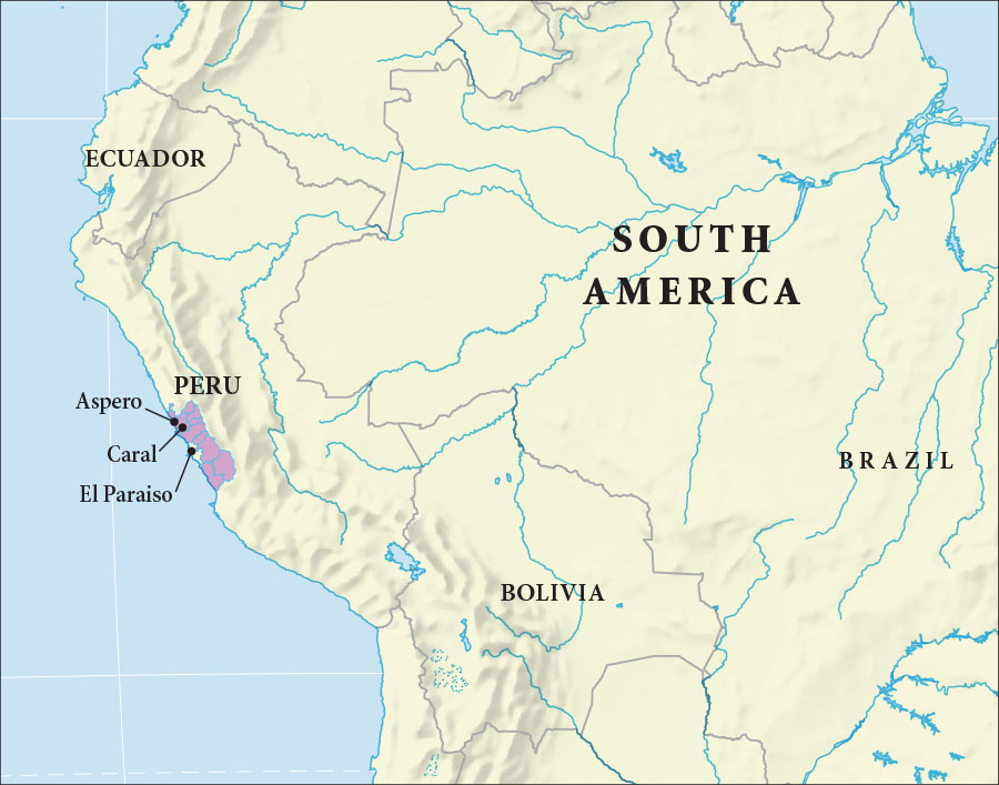
Regardless of when or how the process began, by 3000 BCE, at least partially settled agricultural communities were becoming more common in the Andes region. The similarities among sites in central coastal Peru have led archaeologists to describe them as belonging to one larger culture, sometimes called the Norte Chico or the Caral civilization. A few sites were quite large, such as Aspero, El Paraiso, and Caral (Figure 8.8). Each included multiple mounds and was topped by architectural complexes arranged in a U-shaped pattern. Of the three, Caral is the largest, with a great number of mounds spread across a large area. The largest mound, or the main temple, measures ninety-two feet high and is almost five hundred feet long at its base. Building such a mound would have required a dedicated workforce, suggesting a highly organized society.
英語のヒント
いつ、どのようにその過程が始まったにせよ、前3000年までには、少なくとも部分的には定住する農耕共同体が、アンデス地域でより一般的になっていた。ペルー中部の沿岸の遺跡に共通点があるため、考古学者はそれらを一つの大きな文化に属するものと捉え、「ノルテ・チコ」あるいは「カラル文明」と呼ぶことがある。アスペロ、エル・パライソ、カラルのように、かなり大きな遺跡もあった(図8.8)。それぞれに複数の塚があり、その上にはU字形に配置された建築群があった。この三つのうち最大なのはカラルで、広い範囲に多数の塚が広がっている。最大の塚、すなわち主神殿は、高さ92フィート、基部の長さはほぼ500フィートに達する。このような塚の建設には、専従の労働力が必要だったはずであり、そのことは高度に組織化された社会の存在を示唆している。
Norte Chico Sites.ノルテ・チコの遺跡
(attribution: Copyright Rice University, OpenStax, under CC BY 4.0 license) · CC BY 4.0
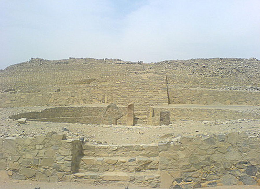
Archaeological evidence indicates that the people who lived at Caral relied primarily on fish and both wild and domesticated crops, such as squash, beans, avocados, and potatoes. As for the social organization of the Norte Chico, we can only speculate, but based on an examination of the burial sites and the likely ritual significance of many of the ruins, there appear to have been social divisions and organized spiritual or religious practice (Figure 8.9). Given the large-scale architecture and the need for laborers, it is also almost certain there was some type of powerful hereditary leadership. And, apart from the structural similarities across the different sites, evidence suggests there were connections between them. For example, the smaller sites along the coast appear to have supplied the larger inland Caral site with necessary marine resources. There may then also have been some type of ruling system over all the various sites, rather than just a similar culture that united them. However, there is no solid evidence to date to support that conclusion.
英語のヒント
考古学的な証拠によると、カラルに暮らした人々は、主に魚と、野生・栽培の両方の作物に頼っていた。作物にはカボチャ、豆、アボカド、ジャガイモなどがあった。ノルテ・チコの社会組織については推測するしかないが、埋葬地の調査や、多くの遺構が持っていたと考えられる儀礼的な意味から見ると、社会的な区分と、組織だった宗教的実践があったようである(図8.9)。大規模な建築と労働者の必要性を考えれば、何らかの強力な世襲の指導体制があったことも、ほぼ確かである。また、各遺跡の構造が似ているというだけでなく、遺跡間につながりがあったことを示す証拠もある。例えば、海岸沿いの小さな集落は、内陸の大きなカラルに、必要な海の資源を供給していたようである。そうであれば、似た文化がそれらを結びつけていただけでなく、各集落全体に及ぶ何らかの支配体制も存在した可能性がある。ただし、これまでのところ、その結論を裏づける確かな証拠はない。
The Caral Culture.カラル文化
(credit: modification of work “Piramide de la Huaca, Caral” by Jose C./Wikimedia Commons, Public Domain) · Public Domain
Figure 8.9 The ruins of the ancient Caral temples in Peru still stand at the site of one of the earliest urban centers in the Americas, with a history going back five thousand years. (credit: modification of work “Piramide de la Huaca, Caral” by Jose C./Wikimedia Commons, Public Domain)
図8.9 ペルーの古代カラルの神殿遺跡は、南北アメリカ最古級の都市中心地の一つに、今も立っている。その歴史は5,000年前にさかのぼる。(出典:Jose C.「Piramide de la Huaca, Caral」を改変、Wikimedia Commons、パブリックドメイン)
Given the great distance and climate differences between the Andean region and Mesoamerica, the agricultural traditions developed in South America were not easily disseminated north into Mesoamerica in Neolithic times. However, it does appear that at least one important Mesoamerican domesticated crop did reach the Andes. This crop was maize, colloquially called corn in the United States. Maize was domesticated from a type of wild edible grass known as teosinte between 5000 and 3000 BCE. While debate continues about how exactly that process occurred, it is generally accepted that human intervention transformed the thick wild grass into the large, sturdy, cob-producing plants we know today. Once domesticated, maize became an important staple carbohydrate in Mesoamerica and led to the rise of large populations. The earliest domesticated maize emerged in either the Tehuacán Valley or the highlands of Oaxaca, from which it was disseminated around Mesoamerica and eventually far beyond. Evidence for Mesoamerican maize in the Andean region dates to about 1600 BCE. There it was commonly used to make a fermented alcoholic drink and popcorn, but it never became an important part of the diet in the way it did in Mesoamerica.
英語のヒント
アンデス地域とメソアメリカの間には大きな距離と気候の違いがあったため、新石器時代、南アメリカで発展した農耕の伝統は、北のメソアメリカへ容易には伝わらなかった。しかし、メソアメリカの重要な栽培作物の少なくとも一つは、確かにアンデスへ到達したようである。それがトウモロコシで、英語ではmaizeといい、アメリカ合衆国の日常語ではcornと呼ばれる。トウモロコシは、前5000年から前3000年の間に、テオシントと呼ばれる食用の野生のイネ科植物から栽培化された。その過程が正確にどのように進んだかについては議論が続いているが、人間の働きかけが、太い野生の草を、現在知られる大きく丈夫で、実の詰まった穂をつける植物へ変えたことは、一般に認められている。栽培化されると、トウモロコシはメソアメリカの主要な炭水化物源となり、大きな人口集団の成立を促した。最初期の栽培トウモロコシは、テワカン渓谷かオアハカの高地のいずれかに現れ、そこからメソアメリカ各地へ、やがてはるか遠方まで広まった。アンデス地域でのメソアメリカ産トウモロコシの証拠は、前1600年ごろにさかのぼる。そこでは、発酵した酒やポップコーンを作るためによく使われたが、メソアメリカの場合のように、食生活の重要な一部にはならなかった。
By around 2500 BCE, a shift toward cooler and wetter conditions in Mesoamerica, combined with the availability of domesticated maize, gave birth to a number of agricultural villages in the region. The residents of these villages typically continued hunting and gathering, but they soon recognized the great advantage of growing maize. Over time, the labor demands of doing so and the caloric value of maize led to a steady decline of gathering activities, resulting in exclusively sedentary agricultural communities. Populations grew, necessitating more farmland to raise even more maize. In this way, maize cultivation expanded across the core regions of Mesoamerica, including southern Mexico and parts of Guatemala. By 2000 BCE, sedentary agricultural settlements had become common across these areas. As occurred in regions around the world during the shift from hunting and gathering to sedentary agriculture, new social hierarchies developed as work became more specialized. These hierarchies were related to not only wealth accumulation but also the rise of leadership power.
英語のヒント
前2500年ごろまでに、メソアメリカでは気候がより涼しく湿潤になる方向へ変化した。それに、栽培化されたトウモロコシを利用できることが加わり、いくつもの農村が生まれた。住民は一般に狩猟採集も続けていたが、ほどなくトウモロコシ栽培の大きな利点に気づいた。やがて、栽培に必要な労働と、トウモロコシから得られる熱量により、採集活動は着実に減っていった。その結果、もっぱら定住農耕を営む共同体が成立した。人口が増えると、さらに多くのトウモロコシを育てるため、農地を増やす必要が生じた。こうしてトウモロコシ栽培は、メキシコ南部やグアテマラの一部を含む、メソアメリカの中心地域へ広がった。前2000年までには、これらの地域で定住農耕集落が一般的になっていた。世界各地で狩猟採集から定住農耕へ移る際に起きたのと同じように、仕事の専門化が進むにつれて、新たな社会階層が生まれた。この階層は、富の蓄積だけでなく、指導者の権力の拡大とも関係していた。
At some point in the late third millennium BCE, maize was eventually disseminated to what is now the southwestern United States. There, groups began using a form of the plant that had been adapted to the drier environment. At this time, it was merely a supplement to other gathered plants, so peoples in this area remained mostly migratory for some time. Over many centuries, they experimented with varieties of maize. They found ways to grow it in high-elevation areas, and they discovered which areas produced the best results, such as floodplains where irrigation occurred naturally.
英語のヒント
前3千年紀の後半のある時点で、トウモロコシはついに、現在のアメリカ合衆国南西部にあたる地域へ伝わった。人々はそこで、より乾いた環境に適応した型のトウモロコシを使い始めた。当時は、ほかの採集植物を補うにすぎなかったため、この地域の人々はしばらくの間、主に移動する生活を続けた。その後、何世紀もの間、さまざまな品種を試した。標高の高い地域で育てる方法を見つけ、水が自然に供給される氾濫原など、どの場所なら最もよい収穫が得られるかも突き止めた。
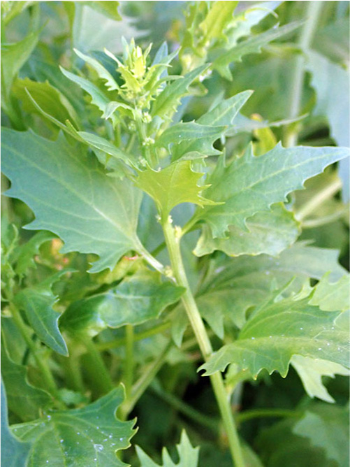
In the Eastern Woodlands, people had been experimenting for thousands of years with naturally occurring edible plants like goosefoot, sunflower, bottle gourds, and squash (Figure 8.10). The use of bottle gourds as containers was an ancient practice in the Eastern Woodlands, and the cultivation of bottle gourds may have been encouraged as long ago as 5000 BCE. Similarly, the domestication of sunflowers, useful for their oily and nutritious seeds, appears to have begun by about 2300 BCE. However, by about 2000 BCE, groups in this region began making concerted efforts to increase their food supply by altering the physical environment, clearing small plots of land to more carefully cultivate these wild plants. Through migration, some transported seeds for certain plants to other areas. Successful techniques for encouraging the growth of these plants were passed from generation to generation. In this way, agricultural cultivation emerged in the Eastern Woodlands independently.
英語のヒント
東部森林地帯では、人々はアカザ類、ヒマワリ、ヒョウタン、カボチャなど、自然に生える食用植物の利用を、数千年にわたり試みていた(図8.10)。ヒョウタンを容器として使うことは、この地域の古くからの慣行であり、早ければ前5000年には、その栽培が促されていた可能性がある。油分と栄養に富む種子を持つヒマワリの栽培化も、前2300年ごろまでには始まっていたようである。前2000年ごろまでには、この地域の集団は、周囲の環境を変えることで食料供給を増やそうと、力を合わせて取り組むようになった。小さな土地を切り開き、これらの野生植物を、より注意深く育てたのである。移住の際に、ある植物の種子を別の地域へ運んだ人々もいた。植物の生育を促すうまくいった技法は、世代から世代へ伝えられた。このようにして、東部森林地帯では独自に農耕が生まれた。
Goosefoot.アカザ類の植物
(credit: “Strawberry Goosefoot (Blitum virgatum)” by Peter de Lange/Wikimedia Commons, CC0 1.0) · CC0 1.0
Figure 8.10 Goosefoot grew wild in North America and was one of the many edible plants gathered by people in the Eastern Woodlands. When consumed, these plants were an important source of vitamins A and C, iron, magnesium, and other minerals. (credit: “Strawberry Goosefoot (Blitum virgatum)” by Peter de Lange/Wikimedia Commons, CC0 1.0)
図8.10 アカザ類は北アメリカに自生し、東部森林地帯の人々が採集する多くの食用植物の一つだった。食べることで、ビタミンA・C、鉄、マグネシウム、その他のミネラルの重要な供給源となった。(出典:Peter de Lange「Strawberry Goosefoot (Blitum virgatum)」、Wikimedia Commons、CC0 1.0)
By the time Eastern Woodlands peoples began cultivating their own native plants around 2000 BCE, they had also begun living in more clearly defined territories. Yet there was communication and trade between different areas. Certain types of stone, copper materials, and shells from the coastlines could pass from one small group to another and in the process move many hundreds of miles. Groups from around a localized region may also have participated in certain ceremonies together. Over time, the increasing availability of food and exposure to wealth in the form of traded materials led to social transformations like a reduction in the egalitarianism common among hunter-gatherers. Burial sites and the increasing number of earthen mounds built from the period demonstrate this.
英語のヒント
前2000年ごろ、東部森林地帯の人々が土地固有の植物を栽培し始めたころまでには、彼らは以前より明確に区切られた領域で暮らし始めてもいた。それでも地域間の交流や交易は存在した。ある種の石、銅の素材、海岸で採れる貝殻は、一つの小集団から別の集団へと渡り、その過程で何百マイルもの距離を移動することができた。同じ地域の周辺の集団が、ある種の儀式に一緒に参加した可能性もある。時がたつにつれ、利用できる食料が増え、交易品という形の富に触れるようになると、社会も変化した。例えば、狩猟採集民に一般的だった平等性が弱まった。このことは、埋葬地や、この時代以降に増えていく土塚からわかる。
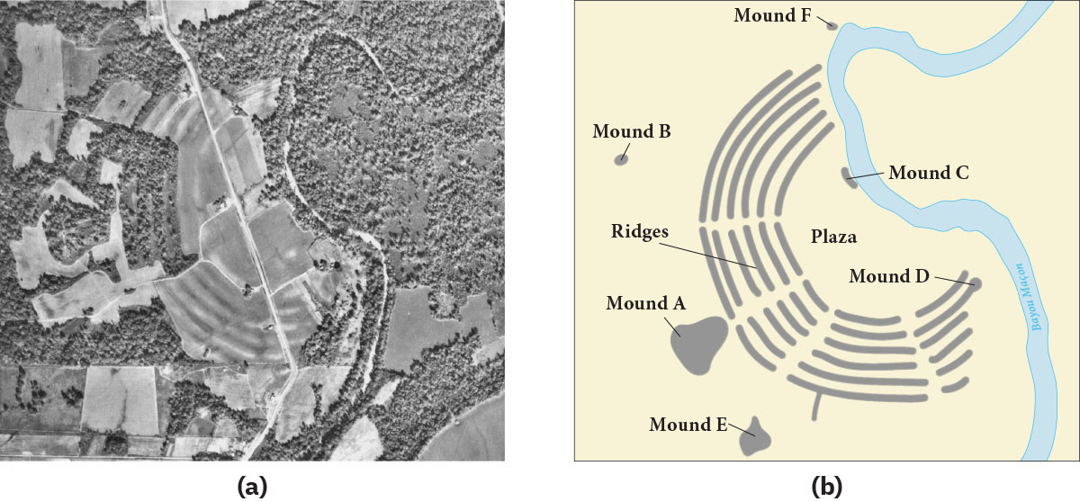
Groups in the Eastern Woodlands remained small, likely no more than one hundred or so members in most places. There were a few exceptions, such as at the large Poverty Point site in northern Louisiana (Figure 8.11). There, beginning around 1000 BCE, several U-shaped concentric mounds were constructed to form an impressive and unusual ceremonial site. The exact purpose of the site and the social organization of the people who built it are not known, but it likely had some ritual significance, and those who lived in and around it employed both hunter-gatherer and agricultural strategies. It was an active site for about three hundred years before being abandoned for reasons unknown.
英語のヒント
東部森林地帯の集団は小規模なままで、多くの場所では、おそらく100人程度を超えなかった。ただし、ルイジアナ北部の大規模なポヴァティ・ポイント遺跡のように、例外もいくつかあった(図8.11)。ここでは、前1000年ごろから、U字形の同心状の土塚がいくつも造られ、壮大で特異な儀礼の場が形づくられた。正確な用途や、建設した人々の社会組織は不明だが、何らかの儀礼的な意味を持っていたと考えられる。その内部や周辺に暮らした人々は、狩猟採集と農耕の両方を用いていた。約300年にわたり利用された後、理由は不明だが放棄された。
Poverty Point.ポヴァティ・ポイント
(credit a: modification of work “Povery Point Site, Louisiana, Aerial Photograph” by USDA Agricultural Stabilization and Conservation Service/Wikimedia Commons, Public Domain; attribution b: Copyright Rice University, OpenStax, under CC BY 4.0 license) · Public Domain + CC BY 4.0
Figure 8.11 (a) The aerial photograph shows what the Poverty Point site in Louisiana looks like today. (b) The schematic shows what it may have looked like at its height. (credit a: modification of work “Povery Point Site, Louisiana, Aerial Photograph” by USDA Agricultural Stabilization and Conservation Service/Wikimedia Commons, Public Domain; attribution b: Copyright Rice University, OpenStax, under CC BY 4.0 license)
図8.11 (a)航空写真は、ルイジアナのポヴァティ・ポイント遺跡の現在の姿を示す。(b)模式図は、その最盛期の姿を推定したもの。(出典a:USDA Agricultural Stabilization and Conservation Service「Povery Point Site, Louisiana, Aerial Photograph」を改変、Wikimedia Commons、パブリックドメイン。出典b:ライス大学・OpenStax、CC BY 4.0)