第4章イスラーム世界The Islamic World
Technology in the Islamic Worldイスラーム世界の技術
Despite the absence of centralized political authority, communication across long distances was possible in the Islamic world because Arabic, the language of the Quran, also served for most scholarly and administrative purposes as well as religious ones. Scholars were widely scattered but rarely were they isolated, and most traders carried letters across long distances as part of their cargo. Scientists were thus able to compare their observations, students learned from advisers and mentors in far-off lands, and members of the ulama sought counsel from colleagues they might never meet.
英語のヒント
中央に集中した政治権力がなくても、イスラーム世界では長距離の意思疎通が可能だった。クルアーンの言語であるアラビア語が、宗教上の用途だけでなく、学術や行政の大半の用途にも使われたからである。学者たちは広く分散していたが、孤立することはめったになかった。また商人の多くは、荷物の一部として遠くまで手紙を運んだ。そのため科学者は観測を比較でき、学生は遠く離れた土地の助言者や師から学び、ウラマーは一度も会うことがないかもしれない同僚に助言を求めた。
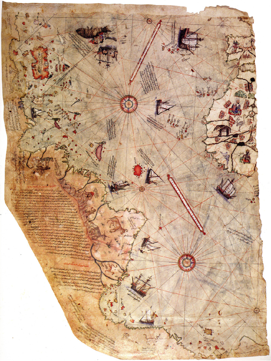
Because of the dominance of trade and travel in the Islamic world, scientific and technological innovations that supported these endeavors were especially prized. Mapmaking, for example, was particularly valued. Maps were created by geographers who collected information about the known world through either their own observations or knowledge disseminated by others. For example, in 1513, the Ottoman admiral and cartographer Piri Reis completed a map of the known world (Figure 4.9). To do so, he relied on observations made by Christopher Columbus, Portuguese explorers in India, and several Arab sources. Unfortunately, only about one-third of his map has survived.
英語のヒント
イスラーム世界では交易と移動が重要な地位を占めていたため、それらを支える科学・技術上の革新はとりわけ重視された。例えば、地図作成は特に高く評価された。地理学者は、自分自身の観察、あるいは他者が広めた知識を通じて既知の世界の情報を集め、地図を作った。例えば1513年、オスマン帝国の提督で地図製作者のピーリー・レイースは、既知の世界の地図を完成させた(図4.9)。その際、クリストファー・コロンブスやインドに赴いたポルトガル人探検家による観察、さらに複数のアラブの資料を利用した。残念ながら、彼の地図はおよそ3分の1しか残っていない。
Piri Reis’s Map of the World.ピーリー・レイースの世界地図。
(credit: “Map of the world by Ottoman admiral Piri Reis, drawn in 1513” by Library of Topkapi Palace Museum/Wikipedia, Public Domain) · Public Domain
Figure 4.9 The only remaining portion of the world map created in 1513 by the Ottoman cartographer Piri Reis shows the Atlantic Ocean bordered by Europe, Africa, and Brazil. (credit: “Map of the world by Ottoman admiral Piri Reis, drawn in 1513” by Library of Topkapi Palace Museum/Wikipedia, Public Domain)
図4.9 オスマン帝国の地図製作者ピーリー・レイースが1513年に作った世界地図の唯一の現存部分は、ヨーロッパ、アフリカ、ブラジルに囲まれた大西洋を示している。(クレジット:トプカプ宮殿博物館図書館/Wikipedia「オスマン帝国の提督ピーリー・レイースが1513年に描いた世界地図」、パブリックドメイン)
One of the travelers who produced a wealth of geographic information for Islamic mapmakers was Ibn Battuta, a fourteenth-century Moroccan reputed to have traveled more than seventy-three thousand miles during his lifetime. He initially journeyed to Mecca to perform the hajj, the Islamic pilgrimage to Mecca, but then decided to continue exploring north and east of Arabia instead of going home. He eventually made his way to China, returning via East Africa and crossing the Sahara to Mali as an envoy of the king of Morocco. Toward the end of his life, Ibn Battuta dictated his memoirs of his travels, which not only were important for mapmakers of his time but also remain a valuable primary source for historians today. Other travelers also produced hajj narratives that pilgrims often used as guides to the lands they passed through.
英語のヒント
イスラームの地図製作者に豊富な地理情報を提供した旅行者の一人が、14世紀のモロッコ人イブン・バットゥータである。彼は生涯に7万3000マイル以上を旅したといわれる。最初は、メッカへのイスラームの巡礼であるハッジを果たすためにメッカへ向かった。しかし、その後は帰郷せず、アラビアの北と東の探訪を続けることにした。ついに中国まで到達し、東アフリカを経由して帰還し、さらにモロッコ王の使節としてサハラを越えてマリへ赴いた。生涯の終わり近くに、イブン・バットゥータは旅の回想録を口述した。それは当時の地図製作者にとって重要だっただけでなく、今日の歴史家にとっても貴重な一次史料であり続けている。他の旅行者もハッジの旅行記を著し、巡礼者は通過する土地の案内としてそれらをしばしば利用した。
Beyond developing devices useful for trade and travel, Islamic innovators also devised systems for using location and compass headings to calculate the qibla, the direction toward Mecca that Muslims must face while praying. Early methods relied on crude directions (“Mecca is east”), but by the ninth century, mathematical calculations were being used. By the fourteenth century, mathematics had progressed to the degree that Shams al-Din al-Khalili, the official timekeeper of Damascus, applied advanced trigonometry to calculate the qibla for a range of locations with such precision that today’s satellite technology is barely able to improve on it. These and other efforts to fix a person’s location on the globe led to advancements in astronomical measurements, as did the need to calculate prayer times each day based on the sun’s position in the sky.
英語のヒント
イスラームの技術開発者は、交易や旅に役立つ器具の開発に加えて、位置と羅針盤の方位を用いてキブラを計算する仕組みも考案した。キブラとは、ムスリムが祈るときに向かなければならない、メッカの方向である。初期の方法は「メッカは東にある」といった大まかな指示に頼っていたが、9世紀までには数学的計算が用いられていた。14世紀までに数学は大きく進歩し、ダマスクスの公式の時刻管理者シャムス・アッディーン・アル=ハリーリーは、高度な三角法を使ってさまざまな地点のキブラを計算した。その精度は、今日の衛星技術でもほとんど改善できないほどだった。地球上の人の位置を定めるこうした取り組みやその他の試みは、天文測定の進歩につながった。空の太陽の位置に基づいて毎日の礼拝時刻を計算する必要も、同様にその進歩を促した。
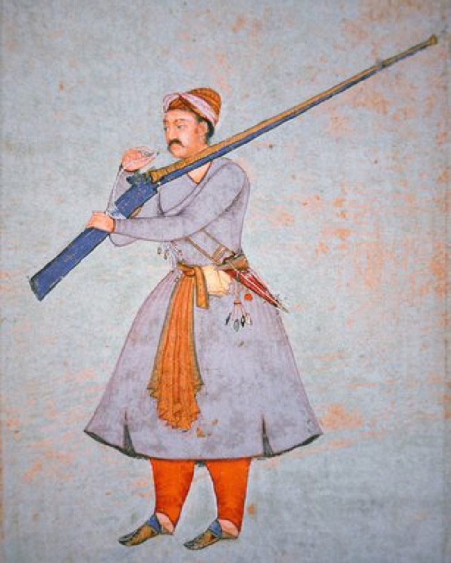
Military technology, especially the use of gunpowder, also greatly advanced in this period. Originally developed in China, gunpowder was transmitted to the Islamic world in the thirteenth and fourteenth centuries, possibly first introduced by the Mongols. By the fifteenth century, the Janissary corps of the Ottoman Empire were using firearms like the arquebus, an early long gun, in battle. And it was the Ottomans who famously used artillery in the siege of Constantinople in 1453. The Ottoman Empire was not the only Islamic state to use and improve upon gunpowder arms. Both the Safavids in Iran and the Mughals in India were famous for their ability to arm their soldiers with firearms like the powerful matchlock rifle (Figure 4.10).
英語のヒント
この時期には、軍事技術、特に火薬の使用も大きく進歩した。もともと中国で開発された火薬は、13〜14世紀にイスラーム世界へ伝わった。最初に伝えたのはモンゴル人だった可能性がある。15世紀までに、オスマン帝国のイェニチェリ軍団は、初期の長銃であるアーケバスなどの火器を戦闘で使用していた。そして、1453年のコンスタンティノープル包囲で大砲を使ったことで有名なのは、オスマン軍であった。火薬兵器を使用・改良したイスラーム国家は、オスマン帝国だけではない。イランのサファヴィー朝もインドのムガル帝国も、強力な火縄銃などの火器を兵士に装備する能力で知られていた(図4.10)。
The Matchlock Rifle.火縄銃。
(credit: “Officer of the Mughal Army, c.1585 (colour litho)” by The Bridgeman Art Library/Wikimedia Commons, Public Domain) · Public Domain
Figure 4.10 The matchlock, shown here in the arms of a Mughal officer in the sixteenth century, was a powerful and portable firearm used by Ottoman, Safavid, and Mughal armies. (credit: “Officer of the Mughal Army, c.1585 (colour litho)” by The Bridgeman Art Library/Wikimedia Commons, Public Domain)
図4.10 この16世紀のムガル帝国の将校が手に持つ火縄銃は、オスマン、サファヴィー、ムガルの各軍が用いた強力な携帯火器であった。(クレジット:ブリッジマン・アート・ライブラリー/Wikimedia Commons「ムガル軍の将校、1585年ごろ〔彩色石版画〕」、パブリックドメイン)
In 1974, historians Marshall G. S. Hodgson and William H. McNeill theorized that the adoption of gunpowder technology was what led to the rise of the Ottoman, Safavid, and Mughal realms, coining the term “gunpowder empires” as a description of them. Today that theory is largely disputed, but the name has remained. What these empires had in common was their conception of the entire state as a military force, in which all political, economic, and cultural resources were coordinated by the central government to strengthen the army and maintain internal and external security. Their view of the state and their ability to consolidate resources in order to pay for technological advances also enabled these three empires to research, develop, and deploy new military technologies, including firearms and cannon, much more quickly than their enemies did. For more than two centuries, they were among the strongest and most stable economies in the world, and their patronage of art and culture produced works of visual art, architecture, and literature that are still considered among the best ever produced. Collectively, the so-called gunpowder empires earned the awe, envy, respect, and fear of their contemporaries in Europe, Africa, and Asia.
英語のヒント
1974年、歴史家マーシャル・G・S・ホジソンとウィリアム・H・マクニールは、火薬技術の採用こそがオスマン、サファヴィー、ムガルの諸国家の台頭をもたらしたと論じ、これらを表す「火薬帝国」という言葉を作った。今日、この理論には多くの異論があるが、名称は残っている。これらの帝国に共通していたのは、国家全体を軍事力として捉える考え方であった。そこでは軍隊を強化し、国内外の安全を維持するため、中央政府がすべての政治・経済・文化的資源を統合して運用した。こうした国家観と、技術的進歩の費用を賄うために資源を集約する能力により、三つの帝国は、銃や大砲を含む新しい軍事技術を敵よりはるかに速く研究・開発・配備することもできた。2世紀以上にわたり、これらの経済は世界で最も強力かつ安定したものの一群に数えられた。また、芸術と文化を保護したことで、今なお史上最高水準とされる美術、建築、文学の作品が生まれた。いわゆる火薬帝国は全体として、ヨーロッパ、アフリカ、アジアの同時代人に、畏怖、羨望、尊敬、恐怖を抱かせた。