第15章サハラ以南のアフリカの国家と社会States and Societies in Sub-Saharan Africa
The Zimbabwean Plateauジンバブエ高原
In the Later Iron Age (c. 900–1600), the Bantu who migrated to southern Africa developed several polities around the Zimbabwean plateau. These included the kingdoms of Mapungubwe and Great Zimbabwe. Although scholars debate which aspects of these societies are derived from the Bantu, the region’s linguistic heritage and archaeological record (in the form of ironwork, enclosure walls, and burial customs) show clear links to the eastern Bantu subgroup.
英語のヒント
後期鉄器時代、約900〜1600年に、アフリカ南部へ移動したバントゥー系の人々は、ジンバブエ高原の周辺に、複数の政治社会を発達させた。マプングブエ王国やグレート・ジンバブエも、その中に含まれた。これらの社会のどの側面が、バントゥー系の人々に由来するかについては、研究者の議論がある。それでも、地域に残る言語の系統や、鉄製品、囲い壁、埋葬習慣といった考古資料は、東部バントゥー系集団との明確なつながりを示す。
The Kingdom of Mapungubweマプングブエ王国
The precise relationship between them remains controversial, but Mapungubwe, which flourished between the eleventh and thirteenth centuries, is often considered the initial stage in the development of Great Zimbabwe. It has been called southern Africa’s first state (Figure 15.13). The origins of Mapungubwe date to around the tenth century with a cattle-keeping culture known as Leopard’s Kopje. In a region of relatively high rainfall near present-day Bulawayo in Zimbabwe, the people of Leopard’s Kopje developed a complex mixed economy of livestock-keeping and herding and agriculture. Like other kingdoms in southern Africa, theirs produced ample food and a surplus they traded for other goods. A unique feature of their farming was a method of terracing the hillsides on the southern slopes of the large sandstone plateau to prevent soil erosion. One such site was Mapela Hill, where during the twelfth century extensive hillside terracing featured dry stone-walling (without mortar) for housing, defense, and cultivation.
英語のヒント
両者の正確な関係には議論があるが、11〜13世紀に栄えたマプングブエは、グレート・ジンバブエの発展の初期段階と、しばしば考えられている。アフリカ南部で最初の国家とも呼ばれてきた(図15.13)。マプングブエの起源は、レオパーズ・コプジェと呼ばれる、牛を飼う文化があった10世紀頃にさかのぼる。現在のジンバブエのブラワヨ近く、比較的雨の多い地域で、レオパーズ・コプジェの人々は、家畜の飼育・放牧と農耕を組み合わせた、複雑な経済を発達させた。ほかの南部アフリカの王国と同じく、十分な食料を生産し、余剰を、ほかの商品と交換した。農業の独特な点は、大きな砂岩の台地の南斜面で、土壌流出を防ぐために、段々畑を造る方法だった。そのような遺跡の一つがマペラ・ヒルである。12世紀に造られた広大な斜面の段々地では、住居、防御、耕作のため、モルタルを使わない石積みの壁が用いられた。
Mapungubwe.マプングブエ
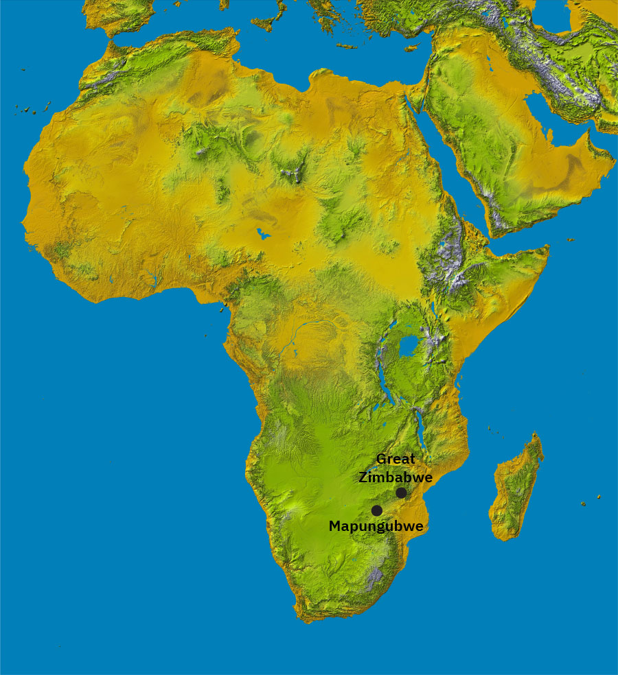
(credit: modification of work “Topographic map of Africa” by NASA/JPL/NIMA/Wikimedia Commons, Public Domain) · Public Domain
Figure 15.13 This map shows the location of Mapungubwe and Great Zimbabwe in the interior of southern Africa. (credit: modification of work “Topographic map of Africa” by NASA/JPL/NIMA/Wikimedia Commons, Public Domain)
図15.13 アフリカ南部の内陸にある、マプングブエとグレート・ジンバブエの位置。(出典:NASA/JPL/NIMA/Wikimedia Commons「Topographic map of Africa」を加工、パブリックドメイン)
Archaeological investigation of the region has revealed the presence of large cattle herds from around the ninth century. Because cattle were the traditional source of wealth and political power in southern Africa, the finding is suggestive of the influence the people of Leopard’s Kopje could exercise. In the tenth century, the economy underwent several important changes, including significant growth in the number of cattle, the development of cotton cultivation and weaving (as indicated by the discovery of spindles), and the introduction of gold mining. The western plateau was rich in gold-bearing rock and was worked intensively by Later Iron Age miners. Narrow shafts were sunk deep into the ground, following the course of seams some ninety feet down. The rock was cracked by alternating use of fire and water and broken out with iron wedges.
英語のヒント
この地域の考古学的調査では、9世紀頃から、大きな牛の群れがあったことが分かっている。牛は、伝統的に南部アフリカの富と政治的力の源だったため、この発見は、レオパーズ・コプジェの人々が行使できた影響力を示唆する。10世紀には、牛の頭数の大幅な増加、紡錘の発見から分かる綿花栽培・織物の発達、金採掘の開始など、経済にいくつかの重要な変化があった。西部高原には金を含む岩石が豊富で、後期鉄器時代の鉱山労働者が、盛んに採掘した。狭い坑道が、鉱脈を追って、地下約90フィート、約27メートルまで掘り下げられた。火と水を交互に使って岩を割り、鉄のくさびで、砕いて取り出した。
Although little is known about the organization and control of this mining work, it is probable that it was largely forced labor. The mining of gold led to a flourishing production of goods for local consumption by elites as well as trade farther afield. A unique type of gold ornamentation found at Mapungubwe (and elsewhere only at Great Zimbabwe) is beaten gold sheets. Decorated with geometric patterns, the sheets seem to have been used to cover wooden pieces, although these have long since rotted away. Other gold objects found at the site include beads, bangle bracelets, and animal figurines.
英語のヒント
採掘作業の組織や統制については、ほとんど分かっていない。それでも、その大部分は、強制労働だった可能性が高い。金の採掘によって、地元の上層者が使う品や、さらに遠くとの交易向けの品の生産が、盛んになった。マプングブエで見つかり、ほかではグレート・ジンバブエでしか見つかっていない、独特な金の装飾品に、打ち延ばした金の薄板がある。幾何学模様で飾られた薄板は、木製品を覆うために使われたようだが、木の部分は、はるか以前に腐って失われた。ほかに、この遺跡では、金のビーズ、腕輪、動物の小像などが見つかっている。
Despite its setting in the southern African interior, Mapungubwe engaged in long-distance trade. Large finds of ivory splinters and animal hides indicate these were being stockpiled for trade (elephants were plentiful in the region). The most probable route for trade was up the Limpopo River to the coastal areas toward Sofala, one of the southernmost regions of the Swahili coast. Other finds, including glass beads from India and fragments of brightly colored India cloth and Chinese celadon (green-glazed) pottery, support this connection with the Swahili coast and its seaborne trade with Arabia, China, and East Asia. While it is possible that Mapungubwe was a terminus for this type of international trade, it was certainly a hub for interregional trade in southern Africa.
英語のヒント
アフリカ南部の内陸という立地にもかかわらず、マプングブエは遠距離交易を行っていた。大量に見つかった象牙の断片や動物の皮は、交易のために蓄えられていたことを示す。この地域には、ゾウが多かった。交易路として最も可能性が高いのは、リンポポ川をさかのぼり、スワヒリ海岸の最南部に近い、ソファラ方面の沿岸へ向かう道だった。インドのガラス製ビーズ、鮮やかな色のインドの布の断片、中国の青磁、すなわち緑色の釉薬をかけた焼き物なども見つかっている。これらは、スワヒリ海岸との結び付き、そして、そこからアラビア、中国、東アジアへ広がる海上交易との結び付きを裏付ける。マプングブエが、そのような国際交易の終点だった可能性はある。少なくとも、南部アフリカの地域間交易の中心であったことは確かである。
Because the Mapungubwean people left no written record, scholars rely on the physical remains of the site to glean hints of its social structure. Mapungubwe is thought to be the first class-based social system in southern Africa, with sharp distinctions between wealthy rulers and their subjects. Commoners lived in mud and thatch dwellings in low-lying areas, district leaders occupied small hilltops on the outskirts of the capital, and the chief or king resided with his court in a stone enclosure at the capital atop Mapungubwe Hill, an imposing structure some 98 feet high and 328 feet in length. The royal wives lived in separate dwellings removed from the king, and the entire royal complex was surrounded by a wooden palisade (Figure 15.14).
英語のヒント
マプングブエの人々は文字記録を残さなかったため、研究者は、遺跡の物的な遺構・遺物から、社会構造の手掛かりを集める。マプングブエは、南部アフリカで最初の、階級に基づく社会制度を持ち、富裕な支配者と、その支配を受ける人々との間に、明確な区別があったと考えられている。庶民は、低い土地の、泥や草ぶきの住居に住んだ。地区の指導者は、都の周辺の小さな丘に住み、首長・王は、宮廷の人々とともに、都のマプングブエ・ヒルの頂上にある、石で囲まれた場所に住んだ。丘は、高さ約98フィート、約30メートル、長さ328フィート、約100メートルという堂々とした姿だった。王の妻たちは、王から離れた、別々の住居に住み、王の居住区全体は、木の柵に囲まれていた(図15.14)。
Mapungubwe Hill.マプングブエ・ヒル
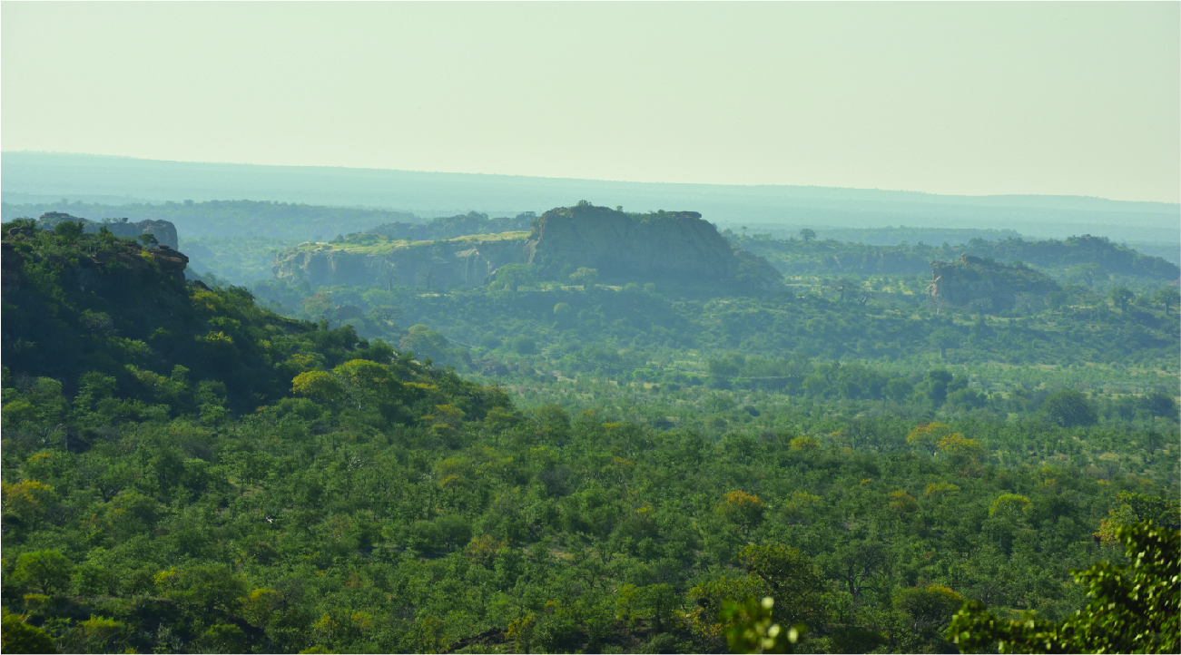
(credit: modification of work “Mapungubwe, Limpopo, South Africa” by South African Tourism/Flickr, CC BY 2.0) · CC BY 2.0
Figure 15.14 Mapungubwe Hill became the center of the Mapungubwe kingdom in the eleventh century, after the population outgrew the earlier center at Leopard’s Kopje. (credit: modification of work “Mapungubwe, Limpopo, South Africa” by South African Tourism/Flickr, CC BY 2.0)
図15.14 以前の中心地レオパーズ・コプジェに人口が収まりきらなくなった後、11世紀、マプングブエ・ヒルは、マプングブエ王国の中心になった。(出典:South African Tourism/Flickr「Mapungubwe, Limpopo, South Africa」を加工、CC BY 2.0)
Mapungubwe fell into terminal decline around the end of the thirteenth century. The precise cause is a matter of speculation, though evidence suggests that the region was subject to a dramatic period of climate change at this time that led to a series of intense droughts. As weather patterns changed and rainfall became less predictable, it caused the land to dry and lose fertility. Pasturage used for livestock dwindled, and the surrounding agricultural farmland, which had once supported a large population, shrank. The failure of crops meant that the once-abundant farms could no longer support the same number of inhabitants, leading to overpopulation and resource scarcity. Around the turn of the fourteenth century, the center of medieval southern African civilization shifted northward where a new polity emerged: Great Zimbabwe. In Bantu, Zimbabwe (dzimba dzamabwe) means “stone buildings,” a telltale marker of the debt the Zimbabweans owed to their southern Mapungubwean neighbors, who had a tradition of building in stone.
英語のヒント
13世紀末頃、マプングブエは、回復しない衰退に入った。正確な原因は推測の域を出ないが、証拠からは、この頃、地域で気候が激変し、激しい干ばつが相次いだことが示唆される。天候の型が変わり、雨の予測が難しくなると、土地は乾き、肥沃さを失った。家畜の放牧地は減り、かつて大きな人口を養った周辺の農地も、縮小した。不作により、以前は豊かだった農場は、同じ人数を支えられなくなった。そのため、人口が土地の扶養力を上回り、資源が不足した。14世紀への変わり目頃、中世南部アフリカ文明の中心は北へ移り、そこに、新しい政治社会、グレート・ジンバブエが現れた。バントゥーの言語で、ジンバブエ(dzimba dzamabwe)は「石の建物」を意味する。それは、石で建築する伝統を持つ、南の隣人マプングブエの人々から、ジンバブエの人々が受けた影響を物語る、明らかなしるしである。