第15章サハラ以南のアフリカの国家と社会States and Societies in Sub-Saharan Africa
15.1 Culture and Society in Medieval Africa15.1 中世アフリカの文化と社会
Learning Objectives学習の目標
By the end of this section, you will be able to:
この節を学び終えると、次のことができるようになる。
Analyze the relationship between the physical geography of Africa and the migration of peoples like the Bantu
アフリカの自然地理と、バントゥー系の人々などの移動との関係を分析する。
Discuss how Christianity and Islam arrived and spread throughout western Africa
キリスト教とイスラームが、西アフリカへどのように伝わり、広がったかを論じる。
As the second-largest continent on the planet, Africa’s vast landmass possesses a great variety of different terrains and climatic regions. In some cases, these regions have inhibited the movement of people, technologies, languages, cultures, and religions. For example, the Sahara stretches from the Atlantic coast of northwest Africa to the Red Sea in Egypt and forms a nearly impassable barrier between the Mediterranean world and sub-Saharan Africa. Only with considerable effort have some groups been able to penetrate this arid zone. For this reason, the people of North Africa have historically had stronger cultural, political, and religious connections to the Mediterranean world than the peoples south of the desert. Other regions like the Sahel (the environmental threshold that is the southern portion of the Sahara) and the tropical woodland savanna are spread across large portions of the continent and have in some ways encouraged the migration of groups. The migrating Bantus, for example, spread their languages and ironworking technology throughout this region.
英語のヒント
アフリカは、世界で2番目に大きい大陸であり、その広大な陸地には、多種多様な地形と気候の地域がある。地域によっては、自然環境が、人々、技術、言語、文化、宗教の移動を妨げた。たとえばサハラ砂漠は、アフリカ北西部の大西洋岸から、エジプトの紅海沿岸まで延び、地中海世界とサハラ以南のアフリカの間に、ほとんど越えられない障壁を作る。一部の集団は、多大な努力によって初めて、この乾燥地帯を通り抜けることができた。そのため、北アフリカの人々は、歴史的に、砂漠の南の人々よりも、地中海世界との文化・政治・宗教上のつながりが強かった。サハラの南縁の環境移行帯であるサヘルや、熱帯の樹木を伴うサバンナは、大陸の広い範囲に分布し、人々の移動を促した面もある。たとえば移動したバントゥー系の人々は、この地域に、自らの言語と製鉄技術を広めた。
African Geography, Migrations, and Settlementアフリカの地理・移動・定住
North of the Sahara is a thin strip of forest and scrubland hugging the southern shores of the Mediterranean Sea. Like other parts of the Mediterranean world, it has a relatively mild climate with sufficient rainfall, wet winters, and dry summers. For this reason, the arable land there is suitable for growing grains like wheat and barley, originally domesticated in the Fertile Crescent and disseminated around the sea over thousands of years. Likewise, this northern African region has had a long history of cultural contact with other Mediterranean cultures like the Greeks, Phoenicians, and Romans. As a result, the cultural practices, religions, and languages of the larger Mediterranean world have had, and continue to have, a huge impact on this region.
英語のヒント
サハラの北には、地中海南岸に沿って、森林と低木地の細長い帯がある。地中海のほかの地域と同じく、比較的穏やかな気候で、降雨も十分にあり、冬は湿潤、夏は乾燥している。そのため、耕作できる土地は、小麦や大麦などの穀物栽培に適する。これらは、もともと肥沃な三日月地帯で栽培化され、何千年もかけて地中海の周囲へ広まった作物である。同様に、北アフリカには、ギリシア人、フェニキア人、ローマ人など、ほかの地中海文化と接触してきた長い歴史がある。したがって、より広い地中海世界の文化的慣行、宗教、言語は、この地域に大きな影響を与えてきたし、今も与え続けている。
South of the Sahara is the Sahel, a semiarid belt of land that separates the desert in the north from the savanna in the south. The Sahel is a transitional zone that stretches some 3,300 miles across the continent. The farther south, the longer is the rainy season (four months on average), the more temperate is the climate, and the greater is the abundance of pasturage and forage plants for livestock (especially cattle and sheep), including grasses, thorny shrubs, and baobab trees. The word Sahel is derived from the Arabic sahil, meaning “shore.” This is a reference to the view held by many that the Sahara was a vast sea of sand that could be navigated only with great difficulty.
英語のヒント
サハラの南にはサヘルがある。北の砂漠と南のサバンナを隔てる、半乾燥の帯状の土地である。この環境移行帯は、大陸を横切って約3,300マイル、約5,300キロメートルにわたって延びる。南へ行くほど、雨季は長くなり、平均で4か月ほどとなる。気候はより穏やかになり、草、トゲのある低木、バオバブなど、家畜、特に牛や羊の餌となる草地や植物も豊富になる。サヘルという言葉は、「岸」を意味するアラビア語のサーヒルに由来する。サハラは広大な砂の海であり、横断するには大変な困難を伴う、という、多くの人々の見方を表した名である。
The Sahara’s extremely dry conditions are hostile to both plants and animals, so only small-scale human settlements are possible. These are clustered around the desert’s oases, which amount to a fraction of a percentage of its total landmass. During the Middle Ages, these oases were crucial hubs connecting trade routes across the desert, nowhere more so than in West Africa, where medieval kingdoms competed for control over markets and the movement of goods across the region.
英語のヒント
サハラのきわめて乾燥した環境は、植物にも動物にも厳しく、人間が暮らせる集落は、小規模なものに限られる。集落は、砂漠全体の面積の1パーセントにも遠く及ばない、オアシスの周囲に集まる。中世には、こうしたオアシスが、砂漠を横断する交易路を結ぶ、重要な中継地だった。特に西アフリカでは、その重要性が際立った。中世の王国は、市場と、地域を横切る物資の移動の支配をめぐって、競い合った。
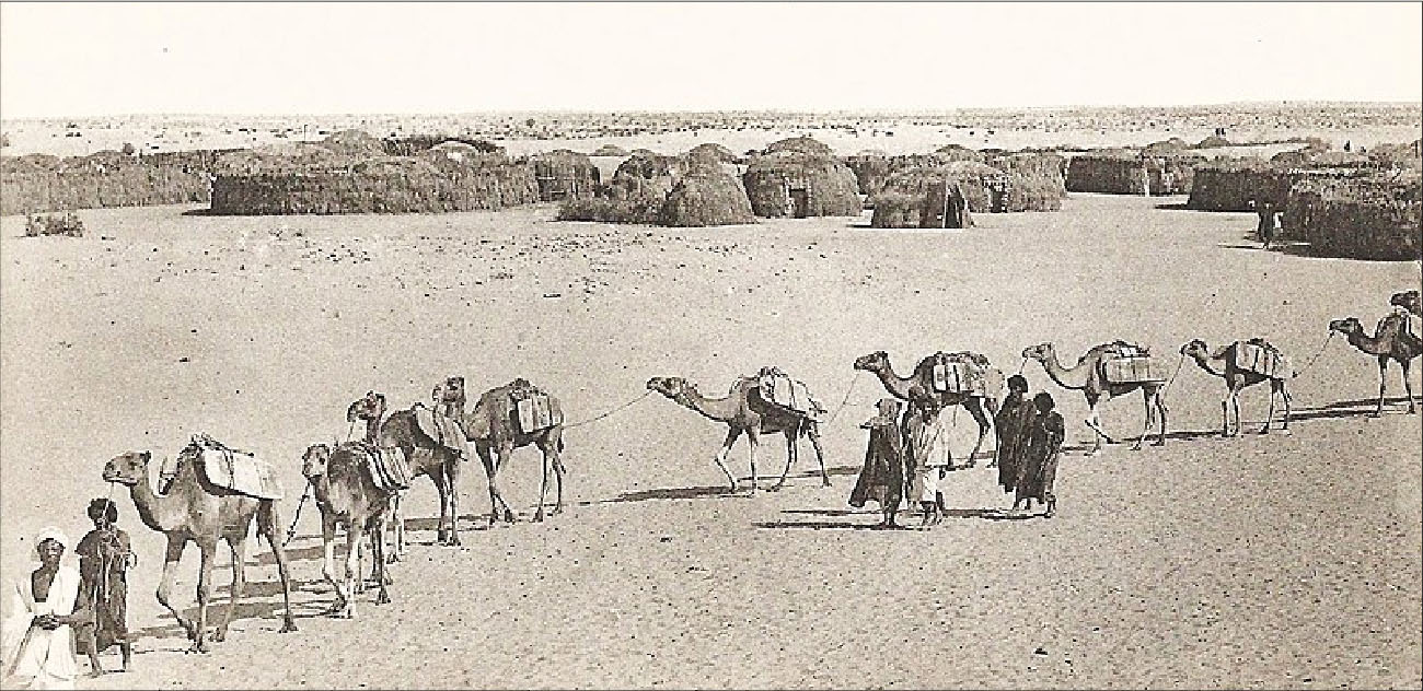
During the medieval period, the Sahara provided powerful West African kingdoms with a vital commodity: salt. Almost completely unobtainable in the inland regions south of the Sahara, salt was mined from sites such as Taghaza and transported in enormous slabs on the backs of camels in caravans that crossed the desert to West African villages and beyond (Figure 15.4). Salt became the second most prized good traded across the Sahara—the first being gold. Indeed, salt was such a valuable commodity that the king of Ghana stored it in the royal treasury alongside gold nuggets.
英語のヒント
中世のサハラは、西アフリカの強力な王国に、欠かせない商品である塩を供給した。塩は、サハラの南の内陸では、ほとんど手に入らなかった。タガザなどで採掘され、大きな板状の塊としてラクダの背に載せられた。隊商は砂漠を横断し、西アフリカの村々や、その先まで塩を運んだ(図15.4)。塩は、サハラ交易で、金に次いで珍重される商品になった。実際、それほど貴重だったため、ガーナ王は、王室の宝物庫に、金塊と並べて保管した。
A Precious Commodity: Salt.貴重な商品、塩
(credit: modification of work “Tombouctou-Arrivée d’une caravane de sel (AOF)” by Collection particulière/Wikimedia Commons, Pubilc Domain) · Public Domain
Figure 15.4 This early twentieth-century photograph shows a caravan of camels laden with sixty-pound slabs of salt crossing the Sahara near Timbuktu. In medieval Africa, salt was second only to gold in value and was transported in much the same way. (credit: modification of work “Tombouctou-Arrivée d’une caravane de sel (AOF)” by Collection particulière/Wikimedia Commons, Pubilc Domain)
図15.4 トンブクトゥ近くでサハラを横断する、20世紀初めのラクダ隊商。60ポンド、約27キログラムの塩の板を積んでいる。中世アフリカでは、塩は金に次いで価値の高い商品で、ほぼ同じ方法で運ばれた。(出典:Collection particulière/Wikimedia Commons「Tombouctou-Arrivée d’une caravane de sel (AOF)」を加工、パブリックドメイン)
The southern frontier of the Sahel is marked by the transition to grasslands and tropical woodlands of the savanna. While the Sahara is dry and arid, the savanna is more temperate and wetter, carpeted with grasses and studded by scattered trees. At its extreme end near the West African rainforests stretching from modern-day Sierra Leone to Ghana, the savanna can see as much as forty-eight inches of rain per year (the rainy season lasts from May to October), which is similar to the average annual rainfall of New York City in the United States. Alongside a greater abundance of vegetation, the savanna is also home to a wider range of wildlife, including cattle, antelope, and giraffes. Endowed with a hospitable environment, climate, and geography, the plains of the savanna have historically been the region with the greatest concentration of human settlement in Africa.
英語のヒント
サヘルの南の縁では、草地と熱帯の樹木があるサバンナへと、景観が変わる。乾いたサハラに比べ、サバンナはより穏やかで湿潤であり、草に覆われ、樹木が点々と立つ。現在のシエラレオネからガーナまで続く、西アフリカの熱帯雨林に近い端では、年間降水量が48インチ、約1,220ミリメートルに達することもある。雨季は5〜10月で、その年降水量は、アメリカのニューヨーク市の平均に似ている。サバンナは、植物が豊かなだけでなく、牛、アンテロープ、キリンなど、より幅広い動物のすみかでもある。暮らしに適した自然環境、気候、地理に恵まれ、サバンナの平原は歴史的に、アフリカで人間の居住が最も集中する地域だった。
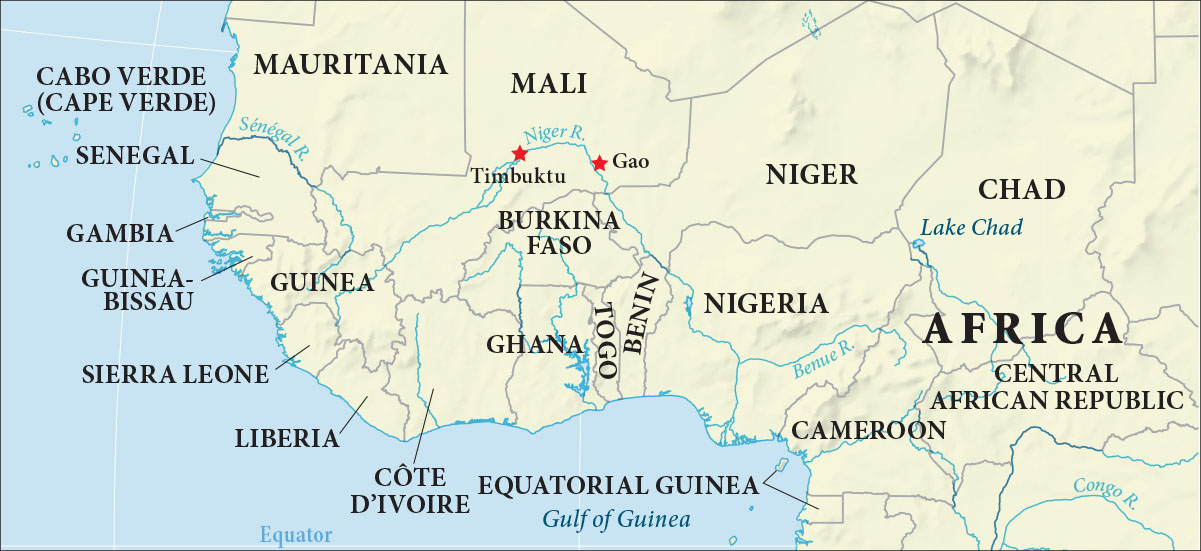
Winding through the savanna and Sahel regions of West Africa is the Niger River. Along its fertile banks, people have grown staple crops like sorghum, African rice, and millet for hundreds of years. Approximately 2,500 miles in length, the Niger is West Africa’s longest river. It was critical to the development of medieval West African kingdoms, both for its ability to sustain intensive agriculture and as a crucial transport conduit for goods and commodities (Figure 15.5). It was in the areas drained by the Niger River where West Africa’s great empires emerged, profiting from the flows of salt from the north and gold from the south. In this way, these empires grew fabulously wealthy.
英語のヒント
西アフリカのサバンナとサヘルを、ニジェール川が曲がりくねって流れる。肥沃な川岸では、何百年もの間、モロコシ、アフリカイネ、雑穀などの主食作物が栽培されてきた。長さは約2,500マイル、約4,000キロメートルで、西アフリカで最も長い川である。ニジェール川は、集約的な農業を支える力と、物資・商品の重要な輸送路という、二つの面で、中世西アフリカの王国の発展に不可欠だった(図15.5)。西アフリカの大帝国が生まれたのは、この川の流域である。北からの塩と、南からの金の流れから利益を得て、途方もなく豊かになった。
The Niger River.ニジェール川
(attribution: Copyright Rice University, OpenStax, under CC BY 4.0 license) · CC BY 4.0
Figure 15.5 From its source in the Guinea Highlands, the Niger, the third-longest river in Africa (after the Nile and the Congo), travels through a great part of the interior of West Africa before emptying into the Atlantic Ocean in southern Nigeria. As the major source of water for both the western Sahara and Sahel, the Niger was crucial to the establishment and development of trading centers at Gao and Timbuktu. (attribution: Copyright Rice University, OpenStax, under CC BY 4.0 license)
図15.5 ニジェール川は、ナイル川、コンゴ川に次ぐ、アフリカで3番目に長い川である。ギニア高地を源とし、西アフリカ内陸の広い範囲を流れ、ナイジェリア南部で大西洋へ注ぐ。サハラ西部とサヘルの主要な水源として、ガオやトンブクトゥの交易拠点の成立と発展に、決定的な役割を果たした。(権利表記:Copyright Rice University, OpenStax、CC BY 4.0)
To the south of the savanna lies the tropical rainforest, Africa’s third major environment alongside the desert and the savanna. Relative to the Sahara, the African rainforest covers a far smaller geographic footprint: some two million square miles, or roughly 10 percent of the continent’s total landmass. Nevertheless, the rainforest is rich in biodiversity, including pygmy hippopotamuses, giant forest hogs, canopy monkeys, and chimpanzees, as well as thousands of species of plants. In West Africa, dense stretches of rainforest can be found in Sierra Leone, Liberia, and Côte d’Ivoire. In this area, the Bantu initially encountered the Nok people, from whom they acquired the metallurgical knowledge that enabled them to move into and later emerge from the equatorial rainforest between 500 and 1000 CE. The gradual dispersal of the Bantu throughout much of southern Africa followed.
英語のヒント
サバンナの南には、熱帯雨林がある。砂漠、サバンナと並ぶ、アフリカの第三の主要な自然環境である。サハラと比べると、アフリカの熱帯雨林が占める面積は、ずっと小さい。約200万平方マイル、約520万平方キロメートルで、大陸の総面積のおよそ10パーセントとされる。それでも雨林の生物多様性は豊かで、コビトカバ、モリイノシシ、林冠に暮らすサル、チンパンジーのほか、何千種類もの植物が生きる。西アフリカでは、シエラレオネ、リベリア、コートジボワールに、密な雨林が広がる。この地域で、バントゥー系の人々は、初めてノクの人々に出会い、冶金の知識を得た。その知識によって、500〜1000年の間に、赤道付近の雨林へ入り、後には、そこを抜けて進むことができた。その後、バントゥー系の人々は、アフリカ南部の広い範囲に、徐々に分散していった。
Bantu speakers had been migrating from this area possibly since as early as 3000 BCE. But with the adoption of ironworking technology from the Nok, these ironworking farmers were able to travel throughout much of the eastern, western, and southeastern regions of the subcontinent. Their Iron Age economy was dominated by farming, mostly of sorghum and millet, with some livestock including cattle, pigs, and chickens, although animal husbandry tended to be secondary to farming. Because the regions into which they moved were only thinly populated by roving bands of hunter-gatherers, the Bantu were able to choose the most suitable land for farming. Early Iron Age Bantu settlements tended to be small, typically consisting of a dozen or so round houses encircling a livestock pen of cattle or goats. Larger settlements (sometimes in the range of several hectares) could be found in regions such as Natal, favored by large Bantu kinship groups because of the combination of rich biodiversity and sparse population. Settlements were placed close to iron ore and wood for the smelting of carbon steel. The early Iron Age Bantu economy necessarily focused on self-sufficiency with little potential for trade, although some small-scale trade did take place, particularly of sought-after commodities like copper and salt in regions of the Congo and Tanzania.
英語のヒント
バントゥー諸語を話す人々は、この地域から、早ければ紀元前3000年ごろには、移動を始めていた可能性がある。ノクの人々から製鉄技術を取り入れると、鉄を扱う農耕民は、サハラ以南の東部、西部、南東部の広い範囲を、移動できるようになった。鉄器時代の経済は、主にモロコシや雑穀の農耕が中心だった。牛、豚、鶏などの家畜も飼ったが、畜産は農業に次ぐ位置にとどまりがちだった。移動先には、移動を続ける狩猟採集民の集団が、まばらに住んでいた。そのためバントゥー系の人々は、農耕に最も適した土地を選ぶことができた。初期鉄器時代の集落は小さいことが多く、一般に、牛やヤギの囲いを、12軒ほどの丸い家が取り囲んだ。ナタールなどでは、ときには数ヘクタールに及ぶ、大きな集落も見られた。豊かな生物多様性と人口の少なさが合わさったこうした地域は、大きなバントゥー系親族集団に好まれた。集落は、炭素鋼の製錬に必要な鉄鉱石と木材の近くに置かれた。初期鉄器時代のバントゥー系の経済は、必然的に、自給自足を中心とし、交易の余地は小さかった。それでも、小規模な交易は実際に行われた。特にコンゴやタンザニアなどでは、銅や塩のように、需要の高い商品が取引された。
Until about the eighth century CE, the Bantu developed and exploited the resources of the more favorable areas and adapted the local environments. Throughout, they remained a stateless society organized along kinship lines. Women tended crops, prepared food, and minded the smaller children, while men tended livestock, hunted for meat and for animal skins for clothing, and engaged in trade with other villages. Women leaders were the exception; archaeological evidence of male dominance is considerable. Authority was decentralized in any case, with no rigidly hierarchical power structure to exercise central authority.
英語のヒント
紀元8世紀ごろまで、バントゥー系の人々は、条件のよい地域の資源を開発・利用し、現地の環境を作り変えていった。その間、親族関係を軸とする、国家を持たない社会であり続けた。女性は作物を育て、食事を用意し、幼い子どもを世話した。男性は家畜の世話をし、肉や衣服用の皮を得るために狩りをし、ほかの村と交易した。女性の指導者は例外的であり、男性優位を示す考古学的証拠は多い。いずれにしても、権威は分散しており、中央の権力を行使する、厳格な階層構造はなかった。
From the tenth century, relatively powerful Bantu kingdoms began to appear in the savanna to the south of the Central African rainforest, and in the plateau between the Zambezi and Limpopo Rivers in the interior of southern Africa. Their large settlements displaced the region’s earlier inhabitants. This revolution in the ancient African political landscape was the combined result of the introduction of Neolithic cultivation and animal husbandry on the one hand, and the adoption of Iron Age technologies, tools, and weapons on the other. The succession of medieval Bantu kingdoms that emerged dominated these regions economically, politically, and culturally.
英語のヒント
10世紀から、中央アフリカの雨林の南のサバンナと、アフリカ南部内陸のザンベジ川・リンポポ川の間の高原で、比較的強力なバントゥー系の王国が現れ始めた。大きな集落は、それ以前の住民を押しのけた。アフリカの政治のあり方を大きく変えたのは、新石器時代の栽培と家畜飼育の導入、そして鉄器時代の技術・道具・武器の採用が、組み合わさった結果だった。次々と現れた中世のバントゥー系王国は、経済、政治、文化の面で、これらの地域を支配した。
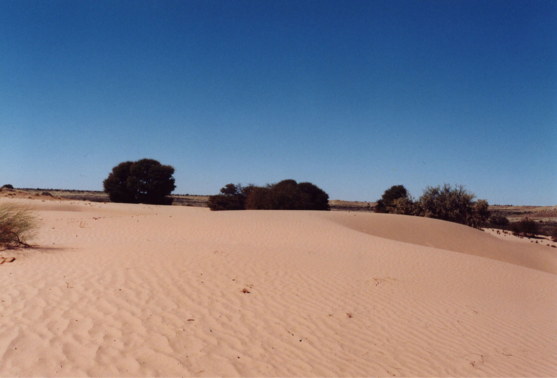
Migrating originally from West Africa, the Bantu would have recognized much of the geography and climate of southern Africa: there is desert, such as the Kalahari and Namib in southwest Africa, and vast savanna. Entire regions of the modern countries of Angola, Democratic Republic of the Congo, Zimbabwe, Zambia, Tanzania, and Mozambique are blanketed by grassland, as is a large area that extends from southern Mozambique into northeastern South Africa. Both the vegetation and wildlife of the southern African savanna resemble that of West Africa in many ways. The southern African climate also has much in common with that of West Africa, encompassing everything from semiarid to temperate zones, with each experiencing varying amounts of rain. Broadly speaking, the eastern area of the region (including Mozambique and eastern South Africa) is wetter than the western area. The west is sapped of moisture, in part by the Atlantic Ocean’s cold Benguela Current. The resulting dryness of western South Africa was a key factor in the development of the Kalahari and Namib Deserts (Figure 15.6).
英語のヒント
もともと西アフリカから移動したバントゥー系の人々には、アフリカ南部の地理や気候の多くが、見覚えのあるものに映っただろう。南西部のカラハリ砂漠やナミブ砂漠のような砂漠があり、広大なサバンナもある。現在のアンゴラ、コンゴ民主共和国、ジンバブウェ、ザンビア、タンザニア、モザンビークでは、地域全体が草原に覆われている所がある。モザンビーク南部から南アフリカ北東部へ広がる、大きな地域も同様である。南部のサバンナの植物と動物は、多くの点で、西アフリカのものに似ている。気候も共通するところが多く、半乾燥から温帯までのさまざまな地帯があり、それぞれの降水量は異なる。大まかにいえば、モザンビークや南アフリカ東部を含む、この地域の東側は、西側より湿潤である。西側の水分が乏しいのは、一部には、大西洋の冷たいベンゲラ海流による。この結果生じる南アフリカ西部の乾燥は、カラハリ砂漠とナミブ砂漠の形成に、重要な役割を果たした(図15.6)。
The Kalahari Desert.カラハリ砂漠
(credit: modification of work “Kalahari” by Quinn Norton/Flickr, CC BY 2.0) · CC BY 2.0
Throughout the Middle Ages, the river systems of southern Africa were exploited by the large civilizations developing there. For example, the Limpopo River basin spreads across the southern reaches of today’s Mozambique and Zimbabwe, the northern extreme of South Africa, and the eastern edge of Botswana. The basin’s temperate climate and well-watered landscape encouraged the migration of San hunter-gatherers from southwestern Africa and the settlement of Bantu peoples. The Bantu, who arrived from the north, brought with them the knowledge of ironworking, farming, and livestock herding they had acquired over generations of migrations throughout sub-Saharan Africa. From the tenth century onward, they used this knowledge to cultivate farms across extensive field systems along the basin and to accumulate large herds of cattle.
英語のヒント
中世を通じ、アフリカ南部で成長する大きな文明は、その地域の河川網を利用した。たとえばリンポポ川の流域は、現在のモザンビークとジンバブウェの南部、南アフリカの最北部、ボツワナの東端に広がる。温暖な気候と豊かな水は、南西アフリカからのサン人の狩猟採集民の移動と、バントゥー系の人々の定住を促した。北から来たバントゥー系の人々は、サハラ以南を何世代もかけて移動する間に得た、製鉄、農耕、家畜飼育の知識を持ち込んだ。10世紀以降、その知識で、流域に広がる耕地を耕し、牛の大きな群れを蓄えた。
As the settlements around the Limpopo River grew, so too did the need to manage the basin’s resources and govern the affairs of the people there. As a result, centralized systems of governance emerged among the Bantu peoples in the region, particularly in the Iron Age culture of Leopard’s Kopje in Zimbabwe. This cattle-keeping culture, whose name derived from the site where it was identified (kopje means “small hill”), dominated the area for nearly two centuries, but by the thirteenth century, it had given way to an even larger and more complex state, Great Zimbabwe.
英語のヒント
リンポポ川の周囲の集落が大きくなるにつれ、流域の資源を管理し、住民の事柄を統治する必要も増した。その結果、地域のバントゥー系社会に、中央へ権限を集めた統治の仕組みが現れた。特に、ジンバブウェの鉄器時代のレパーズ・コピエ文化で、それが見られた。この牧牛文化は、最初に確認された遺跡にちなんで名付けられた。コピエとは「小さな丘」の意味である。約2世紀にわたり地域を支配したが、13世紀までには、より大きく複雑な国家、グレート・ジンバブウェに取って代わられた。